Download
1 / 4
40 likes | 178 Vues
Estimating the Volume of Fine-Grained Sediments Behind Four Low-Head Dams, Kalamazoo River, Michigan. In cooperation with the Michigan Department of Environmental Quality, Environmental Response Division (MDEQ-ERD), the U.S. Geological Survey is estimating

E N D
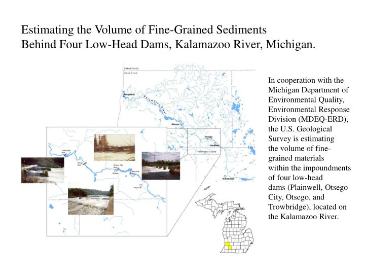
Estimating the Volume of Fine-Grained Sediments Behind Four Low-Head Dams, Kalamazoo River, Michigan. In cooperation with the Michigan Department of Environmental Quality, Environmental Response Division (MDEQ-ERD), the U.S. Geological Survey is estimating the volume of fine-grained materials within the impoundments of four low-head dams (Plainwell, Otsego City, Otsego, and Trowbridge), located on the Kalamazoo River.
Problem The restoration of natural flow regimes to rivers can have significant environmental and aesthetic benefits. In many cases, restoring the natural flow regime requires the removal of non-functioning low-head dams. A series of dams exists on the Kalamazoo River between Plainwell and Allegan, Michigan. All are under consideration for removal in the future. Removal of these dams will return the Kalamazoo River to its pre-dam flow, increase recreation uses and safety of the river, and improve aquatic habitat in this section of the river. The removal of any dam comes with some risks. The two most common problems encountered are the movement of contaminated sediment downstream and the migration of invasive species from the Great Lakes upstream to the headwater areas. Since additional dams downstream of the project will remain in place, migration of invasive species should not be an issue; however, movement of contaminated sediments is a major concern. The USEPA has designated the Kalamazoo River from the city of Kalamazoo to where it discharges into Lake Michigan as a Federal Superfund site. The bed sediments are known to contain PCBs from paper-mill carbonless copy paper production (up to 150 ppm PCB--Blasland, Bouck, & Lee, 1994). Therefore, it is essential that the volume, grain-size distribution, degree of contamination, and potential for down-stream movement of sediments from behind these dams be known before any dam removal can take place. This ongoing multi-phase study will provide valuable information for dam removals on the Kalamazoo River and other dam removal projects in the Great Lakes watershed. This multi-year effort has provided estimates of volume of fine-grain sediment behind three dams; is currently collecting sediment coring data below the Plainwell Dam; plans to continue monitoring streamflow and sediment transport before, during, and after dam removals; and proposes an additional volume estimate at the Otsego City Dam. A sediment-transport model on the upstream Plainwell Dam could be designed and calibrated and would be useful in predicting downstream sediment movement before dam removal takes place. Objectives Estimate the volume, grain-size distribution, and potential for down-stream movement of sediments from behind the Plainwell, Otsego City, Otsego, and Trowbridge Dams. Continue to operate two daily-discharge gaging stations; one above and one below this multi-dam reach. Continue to collect background suspended sediment data (before removals) using automatic samplers at the downstream Trowbridge gage. Design and calibrate a sediment-transport model at the upstream Plainwell Dam that will predict sediment movement from the City of Plainwell to the Otsego City Dam and possibly project similar effects at other dam sites downstream. Document the effects of removal of these dams on the Kalamazoo River environment, including suspended-sediment, bed load, and stream flow. Figure 2. (A) Using auger to determine water depth and sediment thickness. (B) Collecting a core sample. A B
Figure 2. Transect locations. In addition to collecting data along transects, Figure 4. Depth of Water grid. Generated using contours with a 1 ft. contour interval. miscellaneous points were used to collect information at random locations between Grid cell size is 2 ft. the transects (shown in yellow). Figure 6. Thickness of fine-grained material grid. Generated by subtracting grid in Figure 5. Depth bottom of fine-grained material grid. Generated using contours with figure 4 from that in figure 5. Grid cell size is 2 ft. a 1 ft. contour interval. Grid cell size is 2 ft. While the figures depicted illustrate the grids for the Plainwell dam, the above procedure was identically applied to each dam in the study.
Benefits Although engineering studies and construction efforts have addressed the stabilization of some of these dams on the Kalamazoo River (CDM, 1999, 2000, 2001), the consequences of the removal of the dams are basically unknown. The study of these sites provide an opportunity to monitor the actual mobilization, transport, and ultimate fate of contaminated sediment and has substantial potential to advance the understanding of these hydrologic processes and transfer knowledge to other sites. Refinement and improved accuracy of mathematical approaches to contaminated-sediment transport and other impacts at the Plainwell Dam removal site may mean that future downstream dam removals may only require pre-removal “snapshots” of sediment availability and geomorphic assessments, rather than long-term monitoring, at substantial decrease in cost. Data from the proposed study will aid in making decisions regarding removal of the downstream structures more cost effective and scientifically based. Products Technical results of the project will be published in a USGS Water-Resources Investigations Report (WRIR) on the stratigraphy, sedimentology, and volume of fine-grained sediments behind each dam. References: Blasland, Bouck & Lee, Inc., 1994, Allied Paper, Inc./Portage Creek/Kalamazoo River Superfund Site Remedial Investigation/Feasibility Study: draft technical memorandum 10--Sediment Characterization/Geostatistical Pilot Study. Blasland, Bouck & Lee, Inc., 2000, Sediment behind the Plainwell, Otsego, and Trowbridge Dams: Project #--645.24.116 #2, 14 p. Camp Dresser & McKee, 1999, Evaluation Report of Plainwell Dam--Kalamazoo, Michigan: January 1999, 5 p. Camp Dresser & McKee, 1999, Evaluation Report of Trowbridge Dam--Kalamazoo, Michigan: January 1999, 5 p. Camp Dresser & McKee, 1999, Baseline Ecological Risk Assessment--Allied Paper, Inc./Portage Creek/Kalamazoo River Superfund Site: June 1999, various pagination. Camp Dresser & McKee, 2000, Otsego Dam--Evaluation and phase II investigation report: April 2000, 8 p.