Download
1 / 30
310 likes | 466 Vues
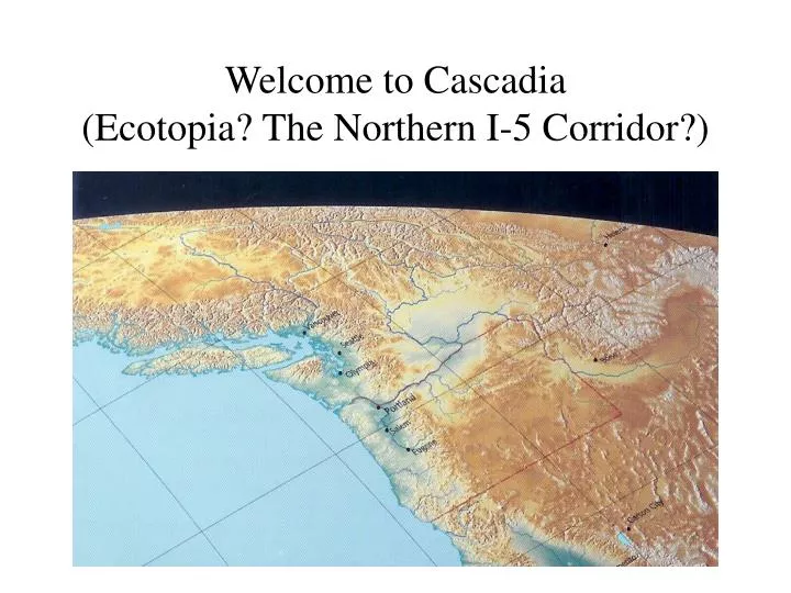
Welcome to Cascadia (Ecotopia? The Northern I-5 Corridor?). APCG - Unit I: Laying the foundation. What’s distinctive about the study of human geography?. More about the perspective used to study phenomena on Earth than about discrete facts and figures.

E N D
What’s distinctive about the study of human geography? • More about the perspective used to study phenomena on Earth than about discrete facts and figures. • The goal of APHG is to understand how and why interconnections are maintained on Earth. • Not simply interested in where things are located and why they’re there…but also interested in the causes, effects, and relationships of patterns and processes.
Greenlandic people and music(Connections/relationships - Inuit and Danish cultures?)
Geography as a field of inquiry Key geographic concepts and models Notable geographers The geographical perspective Space, place, scale Key geographical skills Sources of geographical data and information: census data, field observation, archival information, etc. APHG Unit I - Geography: Its Nature and Perspectives
Student outcomes after learning the content and skills in Unit I • Be able to write one paragraph that describes the geographic perspective and defines what geography is (the essence of geography). • Be comfortable explaining and defending the importance of geography (using key concepts and specific examples of geographic analysis and applications).
Buried in Social Studies after WW II Revolution began in mid-1980s National Geographic Society support Geographic Alliances in every state, and DC, Canada, Puerto Rico National Standards, nat’l assessments, state benchmarks, first-ever AP course approved (that’s us!) But first…how did geography make a comeback in the US?
Four good reasons to be geographically informed… • The Existential Reason: We humans intrinsically want to understand the nature of our home on planet earth. How did the cultures, peoples, and built environment on Earth come to look the way they do?
Why be geographically informed? 2) The Ethical Reason: Earth will no doubt continue to whirl through space for many more millennia. But can it remain in a condition where humans can thrive or even live? Geography provides knowledge about the critical interdependency of all living things.
Four reasons to be geographically informed… • The Intellectual Reason: Geography captures our imagination! It stimulates curiosity about people and places in the world. Geography focuses attention on critically important topics and thus contributes to creating wiser decision-makers…
Another pragmatic reason to be geographically informed… 4) The Practical Reason: Geography has ultimate value in the ‘real world.’ Imagine a doctor who treats diseases who doesn’t understand the environment where it first began and how it spread? Or marketers who don’t know where rice will sell better than french fries - or Portuguese sausages will sell better than bacon?
Spatial Perspective Environmental Perspective Cultural Perspective Synthesizing these three ways of thinking into a holistic approach And integrating some exciting case studies along the way… What is the ‘Geographic Perspective’
The White Mountains (Nevada-California border) Location? Early settlers’ mental maps of California? Human impacts? Economic/cultural relevance?
Spatial analysis is key… A few key concepts: • Location (absolute, relative) • Distance and direction • Accessibility (utility of location, relationships) • Spatial interaction (time-space convergence, interconnections, relationships) • Scale
The concept of scale Definition: Scale is the ratio of distance on map to distance on the ground. Types of map scales: 1) verbal scale (e.g. “one inch on the map = one mile on Earth”) 2) graphic or bar scale 3) representative fraction scale (1:63,360 – numerous advantages!)
Student challenges?? Are you comfortable with this? Map scale has a significant impact on how much detail can be shown on a map. - So the smaller the scale, the larger the area shown on the map. - Large scale maps can show rivers, houses, and all kinds of other details
The regional approach… • Defining regions: The meta-geography of space and place (at local to global scales) • Core concepts: Formal region - political identity Functional region - connected by common themes or activities Vernacular region - defined by local identities
Political regions (states, counties, metropolitan areas) Environmental or physical regions (landforms, climate zones, eco-regions) Economic regions (Silicon Valley, Silicon Hills, Silicon Forest) Cultural regions (based on religions, dialects, ethnicity or race of residents) Regionalizing places close to home
How to regionalize the U.S.?? A few examples…
More on spatial thinking(or ‘we all see the world differently’) • Mental maps • Perception • Sense of place Examples of mental maps? Measuring your mental maps of the U.S.?
APHG ‘free response’ questions to reflect on after studying Unit I… • What is the spatial perspective and how is it used by human geographers? • Why and how do geographers use regions to teach and learn about places on Earth? • List, define, and give an example of three types of map scale.
How to ‘do’ geography (e.g. using Kuby et al this afternoon)? • Data sources • Methods of analysis • Applying the geographic perspective to real world questions and problems • Our Portland project?