Download
1 / 8
80 likes | 92 Vues
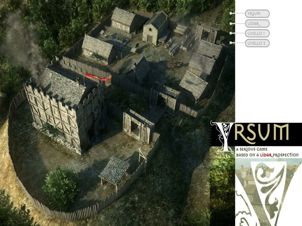
Yrsum is a prototype of a Serious Game that integrates remote sensing data and tools for the virtual reconstruction of a medieval village. Dive into the historical significance of Yrsum, located close to the Northeastern border of Basilicata with Apulia in Italy. Experience the strategic location, human history from the Iron Age to Byzantine times, and key events like its initial documentation in the 12th century and subsequent sacking in 1370. Level 1 involves a site survey using remote sensing data to detect archaeological features such as buried walls of the castle and microrelief related to medieval buildings. Level 2 introduces a puzzle element for the virtual reconstruction of the village, including scenarios on its foundation and urban expansion. Explore detailed maps, building phases, and geomorphological patterns within the game. Immerse yourself in Yrsum's rich history through this interactive experience.

E N D
YRSUM is a prototype of Serious Game in which the remote sensing data and analysis tools are an integral part of the virtual reconstruction of the game environment and the game itself
Medieval village of Yrsum • Irsi o Yrsum o Castrum Ursum close to the Northeastern border of Basilicata with Apulia (Italy) • strategic location: the confluence of the Bradano and Basentello rivers • long human frequentation: iron age, roman period, byzantine age • inhabitants: (550 in 1277 and 5090 in 1320) • 12th century: first documentary attestation • 1123 : Yrsum depends on Episcopate of the near town of Montepeloso • 1133: Destruction of Montepeloso. Yrsum depends on the Abbey of Chaise-Dieu (France) • 1288: first description of a part of the village from a documentary source (a church, a square, some houses, grain storage) • 1370: The village is sacked, the monastery is destroyed. Abandonment of the village.
Medieval village of Yrsum – A Serious Game LEVEL 1 - Site survey by using remote sensing data Archaeological features detected by optical (aerial/satellite) remote sensing 1) Ditch and cropmarks related to buried walls of the castle (A) 2) Microrelief related to some buried buildings of the medieval village (B) Purposes within the game: 1) Detailed map of archaeological features 2) Reconstruction of forma urbis 3) Identification of building phases of the medieval village 4) Geomorphological pattern
Medieval village of Yrsum – A Serious Game LEVEL 1 - Site survey by using remote sensing data Square (platea)? B Castle/Motte A Urban sector extra moenia Niche of detachment C Paleo landlside Landslide slope Landslide foot • From aerial image to airborne laser scanning data • LIDAR Prospection • Classify vegetation • Classify ground • Creating Digital Elevation Model (DEM) • Purposes within the game: • Detailed characterization of the urban shape and terrain morphology
Medieval village of Yrsum – A Serious Game LEVEL 2 - Puzzle