Tactical Overview of the Manzanian-Naranji Conflict: Operations Around Lago Azul
This report details the military movements and intelligence assessments during the ongoing Manzanian and Naranji conflict, focusing on key strategic locations such as Lago Azul, Puerto Limon, and the Escaleras del Sol. Over four days, both forces have engaged in various operations, including vehicular deployment and territory advances, with significant battles reported in Amistad Pass. The report also highlights SAM activity and objectives of vehicular and construction monitoring across multiple sectors. The dynamics of troop movements and air defense strategies are crucial for understanding the evolving battlefield.

Tactical Overview of the Manzanian-Naranji Conflict: Operations Around Lago Azul
E N D
Presentation Transcript
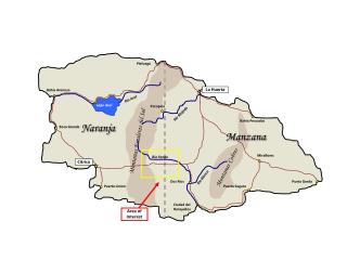
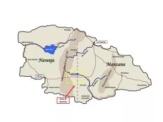
Piefuego La Huerta Bahia Arenoso Rio Azul Lago Azul Pocopico Rio Mojado Bahia Pescados Naranja Boca Grande Manzana Montanas Escaleras del Sol Miraflores Rio Fango Montanas Cobres Citrica Rio Blanco Dos Rios Punta Gorda Puerto Limon Puerto Seguro Ciudad del Ronquidos Area of Interest
Area of Interest – Amistad Pass • Increase swamp size • Swampy area in this section justifies lack of activity or surveillance of this portion of map Rio Fango SAM Site Sudoroso Swamp Gran Roble MAP KEY Road River Swamp Dos Rios SAM Site Forest Foothills Grassland
Day 1 • – Manzanian forces make their initial push into Naranja in an attempt to take control of the country. Northern forces take the towns of Pocopico and Piefuego and advance as far as the Eastern shore of Naranja’s Lago Azul. Southern forces advance quickly, pushing to within 30 miles of the capital city of Citrica. Manzana has moved one Harrier brigade and one Falcon brigade forward to the test sites at Rio Fango and Dos Rios in an effort to maintain air defense of the Amistad battle area. • Intel Report:SAM activity in the extreme Southeastern region • Objectives: • Characterize vehicular traffic in East • Look for construction activity in the West Central region • Look for deployment activity in the North Eastern and East Central regions • Sector Activity: D, I, J, O • Targets/Sector: • D: 2 poss SP arty - dispersed pkg • I: 1 probarmdveh, 1 trk • J: 1 probtrk, 1 prob semi-tlr near road • O: 6 tanks on road in convoy Notes: 2 vehicles also present in E D I J O
Day 2 • – Manzanian forces are stopped East of Puerto Limon and pushed back slightly by Naranji ground forces. Northern forces are similarly pushed back. • Intel Report:SAM activity in the Southern region • Objectives: • Check for vehicles in the interior region • Monitor construction activity in the West Central region and identify any vehicular traffic in the area • Monitor for deployment of vehicles in the North Eastern and East Central regions • Sector Activity: D, E, F, G, I, J, K, L, M • Targets/Sector: • D: 1 poss tank, 1 prob APC • E: 2 poss tanks • F: 1 poss tank, 1 posstrk, 1 UI obj • G: 1 poss tank + 2 posstrks near road • I: 1 possarmdveh, 1 trk (changed positions) • J: 1 probtrk, 1 prob semi-tlr near road (different positions) • K: 2 poss SPAAG and 1 possarmdveh near road • L: 1 prob tank, 1 possapc, 1 poss SPAAG • M: 6 poss tanks in convoy on road D E F G Notes: 2 vehicles in E, moved from Day 1 I J K L M
Day 3 Redraw FLOT to be consistent with storyline (Manzana forces advance to western edge of lake) • Through skillful maneuvering and use of resources, Manzanian forces in the North conduct a brutal counterattack that pushes Naranji forces back to the Western shores of Lago Azul. Nearly one-quarter of Northern Naranja is lost. Meanwhile, combined Naranji regular forces and reserves from Citrica and Puerto Limon in the South manage to push back Manzana’s Southern forces to the foothills of the Escaleras del Sol. Naranji Air Forces (NAF) conduct bombing attacks against Manzanian air defenses that destroy the Harrier SAM sites at Rio Fango, Dos Rios, and Escaleras del Sol and the Condor Site at Punta Gorda Air Defense Headquarters. • Intel Report:SAM activity in the Southern region • Objectives: • Monitor construction/vehicle activity in the West Central region • Monitor vehicle activity in the interior region • Monitor deployment activity in the North Eastern and East Central regions • Sector Activity: D, F, G, I, K, L, M • Targets/Sector: • D: 4 poss SP arty (if rotated, = in firing positions) • F: 1 poss tank, 1 prob trk, 1 UI obj • G: 1 poss tank, 2 poss trk (different positions) • I: 3 prob armd veh, 1 trk (different positions) • K: 1 poss SPAAG near road (different position) • L: 1 prob tank, 1 poss apc, 1 UI obj (different positions) • M: 6 poss tanks in dispersed pkg along treeline G D F I K L M
Day 4 • – Through concentrated effort, Naranji forces push back Manzanian forces in both the North and South. Fighting is heavy in the Amistad pass, which changes hands many times throughout the day • Intel Report: SAM activity in the Southern region • Objectives: • Monitor construction/vehicle activity in the West Central region • Monitor vehicle activity in the interior region • Monitor deployment activity in the North Eastern and East Central regions • Sector Activity: F, G, I, K, L, M • Targets/Sector: • F: 1 UI obj + significant tree clearing 3 objects in scene • G: 1 poss tank, 2 posstrk (different positions). Also, road extensions being built off both sides of the road, one near the clearing • I: 5 poss armored veh, 3 probtrk • K: 3 poss APC near road. Trees near road cleared • L: 1 armored veh, 2 APC. Road being constructed from main road toward clearing & road construction on opposite side of main road • M: 6 poss tanks in dispersed pkg along treeline (same as Day 3) F G I K L M
Day 5 • – Manzanian forces in the North are pushed back half way to Piefuego. In the South, Naranja takes the Amistad Pass and holds Manzanian forces back to the Eastern side of the Escaleras del Sol mountains. • Intel Report: SAM activity in the Eastern region • Objectives: • Analyze construction/vehicle activity in the West Central region • Monitor vehicle activity in the interior and South Western regions • Monitor deployment activity in the North Eastern and East Central regions • Sector Activity: F, G, I, K, L, Q • Targets/Sector: • F: 1 semi-tlr, road constr crosses main road & heads toward woods 3 objs in scene, 2 moved from Day 4 • G: 1 poss tank, 1 poss trk (different positions than previous). Road extension to clearing is now extended further. 3 objs in scene • I: 5 poss armored veh, 3 prob trk (Same as day 4) • K: 2 pos SPAAG, 1 poss APC near road. Road being constr across existing road, heading toward clearing • L: 1 poss tank, 2 APC. New road extended toward clearing. Trees cleared) • Q: 1 prob tank, 1 poss tank, 3 poss trk near treeline. Trees cleared F G I L Q K
Day 6 • – Most of the Manzanian forces have been pushed back across the mountains, except for the heavily defended town of Piefuego in the North. The NAF attempts to destroy the remainder of Manzana’s air defenses, conducting bombing raids against their five remaining SAM sites. Initial reports indicate that attacks against Ronquidos SAM Site West and Rio Mojado SAM Site were unsuccessful, but the Harrier site at La Huerta North and the Condor site at Punta Pescados were successfully destroyed. The Harrier site at Punta Gorda is unlocated at this time. In the center of the Amistad Battle Area, a possible forward command post has been built couth of the General Roberto de Jefe Highway. This possible field command post consists of a road and parking area upon which are parked two command armored personnel carriers (Sector L). • Intel Report: SAM activity in the Southeastern region • Objectives: • Analyze construction/vehicle activity in the West Central region • Monitor construction/vehicle activity in the interior and South Western regions • Monitor interior, North Eastern and Eastern regions for vehicular activity • Sector Activity: F, G, J, K, L, M, Q • Targets/Sector: • F: 1 possarmdveh, 1 posstrk, 1 poss semi-tlr. Cross road lengthened toward (East?) in both directions • G: Status: UNC. 3 probarmdvehs near tree line - SAM site now built at end of road extension. • J: 1 probarmdveh, 1 poss APC, 1 poss SP arty, 1 posstrk on road • K: 1 poss SPAAG, 1 poss APC near road. New road extended. • L: 1 APC, 1 UI obj. New pkg area constr in clearing (no vehs on it at the moment) • M: 2 poss SPAAG, 3 prob APC, 3 probtrk • Q: 2 poss tank, 1 posstrk near treeline G J F K & L: 3rd vehicle in treeline Q K L M
Day 7 • – The town of Piefuego is now back in the hands of Naranja as Naranji forces push remaining Manzanian forces back into the mountains in the North. In the South, Manzanian forces have pushed back into Amistad Pass. A new Harrier SAM site has been built in the Amistad Battle Area, South of the Fango River and just North of the forward command post reported yesterday. The Harrier equipment is assessed to have come from the Punta Gorda Sam Site, which had been previously unlocated. Another SAM site, of possible Harrier configuration, is observed under construction at the Western end of the Amistad Battle Area, in the foothills of the Escaleras del Sol mountains near the highway. A possible SAM support area is also being built just North of this facility. • Intel Report: SAM activity in the Southeastern region • Objectives: • Analyze construction activity in the West Central region • Monitor construction/vehicular activity in the South Western and Interior regions • Monitor and Eastern and North Eastern regions for vehicular activity • Sector Activity: F, G, K, L, M, Q • Targets/Sector: • F: pkg area constr at (West?) end of new road. On new pkg area are 3 vehs: 1 poss tank, 1 probtrk, 1 prob semi-tlr • G: Status: OPR. Vehs parked at each launch posn of new SAM site and on radar mound. (Site operational?) • K: Status: NOP. SAM site now built at end of road extension. 1 prob radar, 3 launchers near launch posns. • L: 2 poss SPAAG and 2 prob APC parked on new pkg area. • M: 2 poss SPAAG, 3 prob APC, 2 probtrk in dispersed pkg along treeline (plus tree clearing?) • Q: Large clearing has been made, and road has been built leading into clearing. 1 prob SP arty, 1 prob tank, 1 probarmdveh, and 3 probtrk are pkd in clearing F G K M: 8 vehicles in scene Q L M
Day 8 • Manzanian forces have retaken the town of Piefuego in the North. In the South, Naranji forces have pushed back to retake most of Amistad Pass but fighting is still heavy in this region. Manzanian air defense forces have completed construction of the Harrier SAM site at the Western end of the Amistad Battle Area, and have brought in Harrier equipment from somewhere to make this site operational. This equipment could have come from one of the two La Huerta SAM sites which perhaps was not fully destroyed as was previously assessed, or perhaps it came from elements of both sites. Manzanian air defense now consists of four short-range Harrier SAM sites: two in the Amistad Battle Area (sectors G & K), one at Ciudad del Ronquidos, and one at Rio Mojado SAM Site. • Intel Report: SAM activity in the Eastern region • Objectives: • Analyze construction/vehicular activity in the West Central, Interior and South Western regions • Sector Activity: F,K, M, Q, U • Targets/Sector: • F: 1 prob tank, 1 possarmdveh, 2 possapcs, 1 probtrk, 1 prob semi-tlr • K: Status: OPR. 4 prob launchers in launch posns, 1 prob radar on radar mound • M: 4 poss SPAAG, 2 APC, 1 trkpkd in defensive positions (circle) (plus tree clearing?) • Q: Clearing and road have been extended. 1 poss SPAAG and 2 trks parked in clearing. • U: Some of the forest was cleared. 1 prob tank, 1 prob APC, 1 probtrkobs in clearing. K M F G & L: Same vehicle as Day 7 (no change) Q U
Day 9 • – Fighting is heavy in the Piefuego region as Naranji forces attempt to retake the town. Manzanian forces have managed to hold onto it for today. In the rest of the region, the battle lines seem to be drawn along the Eastern edge of the Escaleras del Sol mountains. SAM sites at G & K • Intel Report: SAM activity in the Northeastern region • Objectives: • Analyze construction/vehicular activity in the West Central, Interior and South Western regions • Sector Activity: F,G, L, M, N, Q, U • Targets/Sector: • F: 1 prob tank, 1 possarmdveh, 2 possapcs, 1 probtrk, 1 prob semi-tlr (same as Day 8) • G: Status: OPR. Vehs parked at each launch posn of new SAM site and on radar mound. (Site operational?) (Same as Day 7) • L: 2 poss SPAAG and 2 prob APC parked on new pkg area (same as Day 7) • M: 3 poss SPAAG, 1 prob APC parked along new road extension • N: 2 prob SP arty, 1 poss SPAAG, 1 poss APC parked near treeline • Q: Road and clearing have been extended further. No OB observed. • U: Half of the forest cleared. 1 poss tank, 2 poss APCs and 3 probtrk observed in dispersed pkg near trees. F G L M Q N K: Same vehicle as Day 8 (no change) M: Tree clearing south of main road N: Large area cleared south of road K
H: Sector flooded I: Sector flooded. Road under water K: 5 vehicles, same as Day 9 Day 10 • – Naranji forces retake the town of Piefuego, driving Manzanian forces back into the mountains. Other than this, the Forward Line of Troops (FLOT) is the same as it was yesterday. • Intel Report: Due to heavy rains in the area there is possible flooding in the Interior region. • Objectives: • Monitor construction activity in the extreme South Western region • Monitor activity in the West Central region • Monitor construction/vehicular activity in the interior region • Monitor vehicular activity in the South Eastern region • Look for flooding in the interior region • Sector Activity: F,G, K, L, M, N, S, T, U, X, Y • Targets/Sector: • F: 2 prob tank parked along new road, facing (East?). Also 2 poss APC and 2 prob semi-tlr on pkg area • G: Status: NOP. Equip packed up and in convoy on road extension. OB consists of: 3 "launchers", 1 "radar". • L: 1 poss SPAAG and 1 prob APC pkd in pkg area. • M: 1 poss SPAAG and 3 trkspkd along new road extension. [Large dark area on image - is that supposed to be a destroyed area?] Road flooded • N: "Flooding" visible on frame. (OB same as Day 9). Vehicles moved to treeline away from flood waters • S: 2 vehs in clearing, middle of forest • T: 1 poss SPAAG and 1 possarmdvehobs in clearing in forest. • U: More forest cleared. Road now built coming into area from (SE?). 1 poss tank, 2 poss APCs and 3 probtrkobspkd at end of road. • X: 2 prob APCs along treeline. • Y: 1 poss SPAAG and 1 poss APC in forest F G K N L M T U S X Y
F, G, K, L: Vehicles present, same as Day 10 N: Need to replace scene since road was built between Day 10 & 11 even though area was flooded on Day 10 Day 11 • – Naranji forces push into the Amistad Battle Area. In the North, Naranji troops cross through the Cazador Gap and retake the town of Pocopico. Manzanian air defense forces have now built a third Harrier site in the Amistad Battle Area (Sector U, plus existing sites at G & K), this one South of the Manzanian-occupied village of Gran Roble. The site is already operational, with Harrier equipment on all of the launch pads and a Harrier radar on the radar mound. It is assessed that this equipment was built from salvaged and spare parts from previous Harrier sites. Manzanian air defense now consists of five Harrier sites, three of which are defending the Amistad Battle Area. • Intel Report: Intelligence indicates there is SAM activity in the Northwestern region • Objectives: • Check status of flooding in interior region • Monitor construction/vehicular activity in Interior, South Western and South Eastern regions • Sector Activity: M, N, Q, S, U, Y • Targets/Sector: • M: Damage (if that's what it's supposed to be) is repaired. Flood waters receded. 2 poss SPAAG, 2 posstrk parked on road extension. Road extended • N: [Apparently the flooding has built a road for the enemy, because right under the flooded areas, there is now a long road extension.] 1 prob and 1 poss SP arty, 1 APC and 1 armdveh are parked on it. • Q: Convoy of 2 prob tanks, 2 probtrks on road. • S: Clearing greatly enlarged. 2 prob tanks, 1 probtrk and 1 UI veh along treeline in clearing. • U: Status: OPR. SAM site has now been built at end of road. All four launch positions and radar mound are occ with equip. [OB: 4 lchr, 1 radar, 1 trnspr) • Y: Some trees cleared; 4 vehspkd along treeline in small clearing. M N Q U S Y
Day 12 • – All Manzanian forces have now been pushed back over the Escaleras del Sol mountains. Naranji forces have now established a buffer zone around the town of Pocopico in the Eastern foothills of the mountains. • Intel Report: No intelligence data for this mission • Objectives: • Monitor activity in West Central region • Look for construction/vehicular activity in interior and South Eastern regions • Analyze vehicular activity in the South Western region • Analyze activity in extreme Southwestern region • Monitor all roads for vehicular activity • Sector Activity: H, I, N, Q, S, U, Y • Targets/Sector: • H: 3 probtrk, 1 posstrk (supposed to be a tank?) • I: 2 probarmdveh and 2 trk on road • N: Road extension is now much longer, leading off the edge of the frame. No OB observed. • Q: 1 poss APC, 1 prob truck on road. APC appears stopped as it is pkd perpendicular to the road. • S: Clearing enlarged again, road now enters clearing from (SE?). 2 poss APC, 2 probtrkspkd in clearing. • U: Status: OPR. 2 lchr in lchposn, 1 radar on mound. • Y: Major clearing; road built thru clearing. 2 poss APCs and 2 posstrkpkd at end of road. F, G, K, L: Same vehicle as Day 12 (no change) U: 3 vehicles departed, remaining vehicles re-oriented I Y H N Q S U
Day 13 • – Naranji troops from the Northern and Southern fronts meet Southeast of the town of Pocopico and make a coordinated push toward the East. Since this area is lightly defended, large areas of ground are gained. The Naranji Air Forces (NAF) conduct bombing raids in an attempt to destroy all of the five Manzana Harrier sites. The NAF is once again unsuccessful in taking out the site at Ciudad del Ronquidos, but reconnaissance confirms that the new site South of Gran Roble has been destroyed. Heavy ground fire prevents reconnaissance of the other three sites, delaying further confirmation of the success of the airstrike. • Intel Report: Intelligence indicates there is SAM activity in the Southwestern region. • Objectives: • Monitor Southeastern region for construction/vehicular activity • Monitor roads for vehicular activity • Sector Activity: F,G, H, I, K, L, N, S, U, Y • Targets/Sector: • F: 2 prob tank parked along new road, facing (East?). Also 2 poss APC and 2 prob semi-tlr on pkg area (same as Day 10) previous days • G: Status: NOP. Equip packed up and in convoy on road extension. OB consists of: 3 "launchers", 1 "radar“ (same as Day 10) previous days • H: 3 prob armd veh, 3 trks • I: 2 prob armd veh, 2 prob apcs, 3 trks on road • K: Status: OPR. 4 prob launchers in launch posns, 1 prob radar on radar mound (same as Day 8) • L: 1 poss SPAAG and 1 prob APC pkd in pkg area (same as Day 10) previous days • N: 3 prob tanks and 2 poss SP arty are observed parked near the crossroad of the old and new roads. • S: More clearing; road now runs entirely thru area (curves to SE). 2 prob tanks and 2 prob trks obs in convoy along road. • U: Status: NOP. Site has been damaged, but all lch posns and radar mound remain intact. OB: 1 radar and 1 lchr, neither in posn. • Y: Road now runs completely thru forest. 2 prob armd veh and 2 prob trk seen in convoy along road. Q: Same vehicle as Day 12 (no change) U: No damage to site. This comment should be for Day 14 SAR on next chart
I G F H K L N S U Y
Day 14 • – Manzanian troops stop the advance of Naranji forces and push back the center, but give way slightly in the South. Naranji troops advance to within 40 miles of the town of Dos Rios. Naranji forces set up permanent defensive positions in the Amistad Battle Area for the first time in the conflict. Second day post-strike reconnaissance confirms that all Manzanian Harrier sites except for the site at Ciudad del Ronquidos have been destroyed. However, intelligence sources now indicate that the Condor site at Punta Pescados has been hastily repaired in the past week and is now operational. • Intel Report: Allied forces conducted a bombing mission in your area of operations. Intelligence indicates there is SAM activity in the Southern region. • Objectives: • Characterize BDA in West Central and extreme South Western regions • Monitor roads for vehicular activity • Monitor Northern region for deployment activity • Sector Activity: B, C, D, F,G, H, I, J, K, L, N, S, Y • Targets/Sector: • B: 4 armored vehs parked in trapezoidal defensive pattern • C: 5 trucks, 1 poss armd veh in dispersed parking pattern • D: 1 poss SP Arty and 4 prob trk - dispersed pkg • F: Area bombed along new road near new pkg area. 1 prob trk and 2 prob UI obj remain. Bomb damage also observed at (East?) end of road. • G: Status: NOP. SAM Site bombed. Radar mound, 3 launch posns intact. No radar present. 3 launchers in dispersed pkg, 1 dest launcher in dest launch posn. • H: 3 prob armd veh, 3 trks (same as Day 13, but all vehicles re-oriented) • I: 2 prob armd veh, 2 prob apcs, 3 trks on road (different positions) • J: 1 prob armd veh, 1 poss APC, 1 poss SP arty, 2 poss trk on road • K: Status: NOP. SAM Site bombed. Only 1 launch posn intact. 1 radar, 2 launchers, and 1 semi-tlr in dispersed pkg, 1 dest launcher near dest launch posn. • L: Blast areas evident near pkg area, but pkg area untouched. Additional crater on nearby road. 1 poss armd veh and 1 prob APC pkd near pkg area. • N: 3 prob tanks and 2 poss SP arty are observed parked near the crossroad of the old and new roads (same as Day 13) • S: More clearing; road now runs entirely thru area. 2 prob tanks and 2 prob trks obs in convoy along road (same as Day 13) • Y: Road now runs completely thru forest. 2 prob armd veh and 2 prob trk seen in convoy along road (same as day 13) Q: Same vehicle as Day 13 (no change) U: Comment from Day 13 should appear here SAR on next chart
F G B C D H I J K L N S Y
Day 15 D: 12 vehicles total F: 6 vehicles total G: bomb damage repaired, 5 vehicles N: 3 vehicles, same as Day 14 Q: Vehicles present, same as Day 14 U: Vehicles present, condition same as Day 14 (bomb damage) • – Naranji forces push back all Manzanian troops to positions well East of the original Naranja-Manzana border. Naranji armies are now within 40 miles of the capital city of La Huerta in the North and the towns of Dos Rios and Ciudad del Ronquidos in the South. Late in the evening, Manzanian diplomats call for negotiations and at the end of the day, both sides agree to a temporary cease-fire. • Intel Report: Intelligence indicates there is SAM activity in the Southwestern region. • Objectives: • Analyze activity in West Central region • Monitor vehicular activity on roads • Monitor Northern region for deployment activity • Sector Activity: C, D, F,G, K, L, N, S, Y • Targets/Sector: • C: 1 poss tank, 1 poss SP arty, 1 prob trk - dispersed pkg. • D: 3 prob tanks, 1 prob armd veh, 1 poss SP arty, 4 prob trks. • F: Bomb damage partially repaired - 2 poss apcs, 1 prob trk and 1 poss semi-tlr parked in pkg area and 1 prob armd veh and 1 UI obj parked on grass in area of previous bomb damage. • G: Status: OPR. • K: Status: OPR. SAM site rebuilt. 4 lchrs present in lch posns and radar present on radar mound. • L: Site has been repaired. 1 poss armd veh and 1 prob APC pkd near pkg area. • N: 3 prob tanks and 1 poss SP arty are observed parked near the crossroad of the old and new roads. • S: 3 prob tanks and 4 prob APCs obs in convoy along road. • Y: 4 poss SPAAG and 5 trks obs in convoy along road. C D F G K L S N Y