Download
1 / 41
480 likes | 840 Vues
A Journey through the Long Island Sound Watershed. Project Themes. Watershed Long Island Sound Human Impact Positive and negative effects on water quality. Project Themes. Water Quality Its effect on the environment Fieldwork Coastal studies. What is a Watershed?.

E N D
Project Themes Watershed • Long Island Sound Human Impact • Positive and negative effects on water quality
Project Themes Water Quality • Its effect on the environment Fieldwork • Coastal studies
What is a Watershed? The entire area of land that water (from streams, rivers, lakes, ponds, and precipitation) travels over to get to one larger body of water.
Boundaries of a Watershed • The physical features (topography) of the land, such as hills, rivers, and mountains, create the boundaries of a watershed • The orange arrows drain into one watershed • The yellow arrows drain into a separate watershed
Boundaries of a Watershed Water flows down from higher to lower elevations. The highest elevation in our watershed is 4,380 ft. What is the lowest point in our watershed?
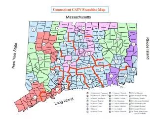
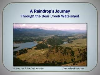
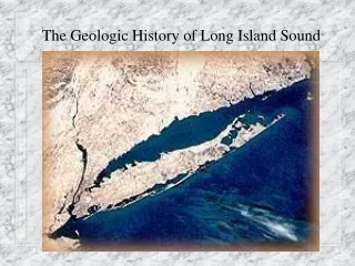
This is a map of the Long Island Sound Watershed. How many states? 6 states How many countries? 2 countries “More than 8,000,000 million people live in the Long Island Sound watershed.” Save the Sound 1 1 2 2 3 5 6 4
Does the Long Island Sound Watershed Contain Smaller Watersheds? Connecticut Thames Housatonic Central Coastal Western Coastal
What is an Estuary? Long Island Sound is an Estuary An estuary is the area where fresh and salt water mix to make brackishwater.
What is the salt water input into Long Island Sound? The Atlantic Ocean Why does LIS contain brackish water? What are the fresh water inputs into Long Island Sound? • Rivers, streams, ponds, lakes, precipitation, and groundwater
You are now going to journey through the watershed to see how each part functions and affects Long Island Sound.
1 – Highlands In higher elevations there is more precipitation, which introduces frozen fresh water.
What do you think number 2 represents? Highlands 2
2 – River When snow melts, the water flows downstream forming rivers or adding to existing ones.
The Connecticut River is the largest river in our watershed. • It starts in Canada and drains into Long Island Sound, traveling a total of 410 miles.
What do you think number 3 represents? Highlands 3 River
3- Tributaries Many rivers have smaller branches, called tributaries that meet the main river.
What do you think number 4 represents? Highlands Tributary River 4 4
4 – Populated Areas The river continues through cities and farms where it can pick up pollutants.
What do you think number 5 represents? Highlands Tributary River City Farm 5
5 – Body of Water The tributaries and rivers eventually connect to a larger body of water, such as a pond, lake, ocean, or estuary like Long Island Sound.
Can humans affect the quality of the water as it travels through the watershed? Highlands Tributary River City Farm Body of Water
As Water Moves Over Land Negative Influences Point source Pollution • Dumping chemicals directly into a storm drain Non-Point Source Pollution • Runoff from streets, parking lots, agricultural areas, and factories
As Water Moves Over Land Positive Influences To surrounding areas • Fresh water for nearby communities To water source • Minerals from the surrounding land enhance water quality
Now that we’ve looked at our local watershed… Let’s go global!
World Water Supply • 97% is salt water (blue) • 2.5% is frozen fresh water (red) • 0.5% is usable fresh water (yellow) If only 0.5% is usable fresh water….
How Healthy is Your Water? • Scientists all over the world test the following factors to measure water quality • Salinity • pH • Temperature • Depth • Turbidity • Dissolved oxygen (D.O.)
And you will get to test these too! • When SoundWaters visits your school • In the Spring on the Long Island Sound
Why Do We Collect Data? • Measure health and changes of water over time • Make comparisons between locations
Name 1 fresh water and 1 salt water source for Long Island Sound What is an estuary?
Identify the numbered parts of the watershed 1 3 2 4 4 5 Remember, water flows downhill.
Name a positive and a negative influence as water moves through the watershed
Remember, only 0.5% of the world’s water is usable fresh water!
Measuring water quality is a way to ensure the health of the water we use every day. The next step is water quality testing in your classroom!
CONGRATULATIONS!!!! You have completed the first step in your water quality study!
Additional Resources • NOAA, the National Oceanic and Atmospheric Administration, is a federal agency that focuses on the condition of the oceans and the atmosphere • NERRS, the National Estuarine Research Reserve System, is a network of 27 Estuary Reserves around the country that focuses on water quality monitoring, education, and coastal stewardship • Estuaries.gov is a website created, with the help of NOAA, to advance estuarine and coastal literacy Visit these sites to learn more about coastal research, other estuaries, and their projects
Photo Sources • http://soundbook.soundkeeper.org/chapter.asp?ContentID=210&SectionID=6 • http://www.mostreamteam.org/Documents/Fact%20Sheets/16535.pdf • http://www.twp.west-bloomfield.mi.us/departments/images/watershed_000.jpg • http://www.napawatersheds.org/Content/10127/What_is_a_Watershed.html • http://www.indiamike.com/photopost/data/504/P7090181_Stream_meeting_the_river_from_the_bus_window_onthe_way_to_Jammu.JPG • http://www.ongov.net/lake/gif/ol361a.png • http://www.greenwichblog.com/2009/07/long-island-sound-cruise • http://geology.com/satellite/connecticut-satellite-image.shtml • http://ian.umces.edu/imagelibrary/displayimage-random-0-475.html • http://www.unbf.ca/arts/IDS/Dev/images/600px-Globe.png • http://www.ct.gov/dep • http://www.blackmbahartford.com/hartford-skyline.jpg • http://rudebutgood.blogspot.com/2012/01/states-in-united-states-of-america.html • http://www.americandrivingvacations.com/trips/bestofnewengland/bestofnewengland07.html • http://www.theolinstudio.com/blog/mill-river-park-groundbreaking/ • http://www.nature.org/ourinitiatives/regions/northamerica/areas/easternusmarine/overview/index.htm • http://upload.wikimedia.org/wikipedia/commons/2/2f/USACE_West_Branch_Reservoir_and_Dam.jpg • http://earthimage.wordpress.com/2011/09/09/best-farm-soil-flows-to-sea/ "Save the Sound." CT Fund for the Environment. Save the Sound, Web. 12 Dec. 2012.http://www.ctenvironment.org/save-the-sound/