The Pantanal
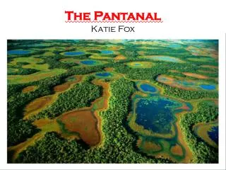
The Pantanal. By: Stephanie Gary, Autumn Carey, Jenni Scotti, Katy Marlor, and Morgann Dalby. WHERE IS IT?. Shares its borders with Brazil, Bolivia, and Paraguay. Half the size of France, 4 times the size of the Everglades. Pantanal derived from Portuguese Word ‘pantano’, meaning swamp.

The Pantanal
E N D
Presentation Transcript
The Pantanal By: Stephanie Gary, Autumn Carey, Jenni Scotti, Katy Marlor, and Morgann Dalby
Shares its borders with Brazil, Bolivia, and Paraguay Half the size of France, 4 times the size of the Everglades Pantanal derived from Portuguese Word ‘pantano’, meaning swamp
Physical features Geological Evolution History of Formation Pantanal
Geography And Climate
Flood Plain Wetland Paraguay River Basin Semi-Arid Zone Types of Habitat
Climate & Seasons Rainy Season: Region dominated by West winds; Sun is at its highest point; Cold Air masses moving northward across South America; October-March Water levels rising Dry Season: Sun at its lowest point above the earth; Rising dry air dominates the region; Drying pools left behind as flood waters retreat, then dry up completely; Dissolved O2 levels in the water; April-October
Plant Diversity in the Pantanal Soil content during flood seasons and dry seasons account for the diversity of plants found in the Pantanal Rainy season: Calcium, Magnesium, Potassium Dry season: Nitrogen, Phosphates
Plants of the Dry Season • Algae and bacteria are most common during the dry season • Most common species found are diatoms, phytoflagellates, and desmids
Plants of the Wet Season Salvinia auriculata is one of the most important plants found in the Pantanal It is originally from the more nutrient rich waters in the American tropics but is flourishing in the Pantanal
Cabomba furcata has massive underwater beds and pink flowers. After the flower is pollinated, it dips below the surface of the water to allow the fruit to develop
One of the more common trees of the Pantanal is Tabebuia ipe. • These trees can grow up to 120 feet tall and have trunk diameters of up to 3 feet.
Victoria regia is a species of water lily. • Each pad can grow up to 2 meters in diameter. • Usually found in stagnant waters and in rivers Victoria regia is a species of water lily. Each pad can grow up to 2 meters in diameter. Usually found in stagnant waters and in rivers
Carniverous plants also exists within the Pantanal • 2 species are: • Dionaea muscipula (Venus fly trap) • Utricularia
VENUS FLY TRAP Venus Fly Trap This plant has 2 brightly colored pads joined in the middle Each pad has 3 tiny hairs that trigger the pads closing • This plant has 2 brightly colored pads joined in the middle • Each pad has 3 tiny hairs that trigger the pads closing
Utricularia • There are many species of utricularia that exists. • Examples: U. gibba and U. foliosa • Traps its prey in a sac attached to the leaves.
PLANT ADAPTATIONS • Aerenchyma • Buttress/prop roots • pneumatophores
Amazonian Manatee • occurs exclusively in fresh water. It prefers blackwater lakes, oxbows, and lagoons with deep connections to large rivers and abundant aquatic vegetation • ranges throughout the Amazon River Basin of northern South America. Its range sometimes has been said to include the Orinoco River Basin • populations of the central Amazon Basin make an annual movement in July - August, when water levels begin to fall • Some return to the main river channels when the rivers shrink in the dry season
do most of their feeding during the wet season, when they eat new vegetation in seasonally flooded backwaters • during the dry season (September - March), they congregate in the main river channels or in deep parts of larger lakes and may fast for weeks or months for lack of available food plants • manatee's large fat reserves and low metabolic rate, only about 1/3 of the usual rate for most mammals, allow it to survive at this time
Subsistence and commercial hunters have long hunted the Amazonian manatee • Its populations continue to decline, mainly due to hunting • Other threats include accidental drowning in commercial fishing nets and degradation of food supplies by soil erosion resulting from deforestation Threats
Pink Dolphin or Boto • occurs throughout much of the Amazon and Orinoco watersheds, being found almost everywhere it can physically reach without venturing into marine waters • central Amazon basin, large changes in water levels affect the local distribution of botos • significant increases in water level during the flood season leads to the inundation of large areas of forest • Botos move out of the main river into channels and small lakes and then into the forest itself, swimming among the trees
There are 10 major dams at present in the Amazon basin, of which 8 have isolated boto populations upstream • These dams have caused fragmentation of the pink dolphins • Since the boto feeds on dozens of species of fish, they are isolated from fishing locations in part by the dams • Dams suppress natural fluctuations in flow, temperature, and detritus loading, which provide optimal conditions for a large number of aquatic organisms • The boto is vulnerable to human-induced habitat changes and suffers some incidental mortality in fisheries • Threats include being accidentally caught in fisheries, hydroelectric development, deforestation, and pollution from agriculture, industry and mining
The yellow is degraded forest and agriculture. In the bottom figure, the mauve is the flooded forests.
The correlation between soil water and logging and the potential for fires in the forest.
1987 1981 1989 Carbon source Carbon Sink
The annual CO2 release of each ecosystem. In 1983 and 1986 the rainforest releases CO2 into the biosphere. In 1988 and 1992, the rainforest becomes more what it is naturally, a CO2 sink.
Number of dead and alive Vochysia divergens on different study plots Phenotypical aspects of Vochysia divergens and different water levels and precipitation over a year Survival of Vochysia divergens after 5 month flooding
What needs to be done? Deforestation • Agriculture • Using smaller areas • Let the forest repair itself • Logging • Low impact harvest techniques • Reduced impact logging • Long-term planning
Gold mining • Less is more • Mercury • Find other methods for mining gold • Invasive species • Habitat • Don’t create habitats invasive species can choke out the native one • Example- abandoned graze lands • If all goes well things can improve • Environment • Climate • People • world
Educate!! • The whole world needs to work together • Understanding of how important the forest is • Understanding of what we need to do • FUTURE Learning about the consequences and how The whole world is affected by this ecosystem