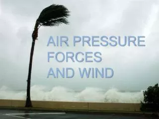
Chapter 5: Atmospheric Pressure and Wind
480 likes | 1.1k Vues
Chapter 5: Atmospheric Pressure and Wind. The Impact of Pressure and Wind on the Landscape. Atmospheric pressure indirectly affects the landscape Changes manifest primarily by changes in wind and temperature Wind has a visible component to its activity

Chapter 5: Atmospheric Pressure and Wind
E N D
Presentation Transcript
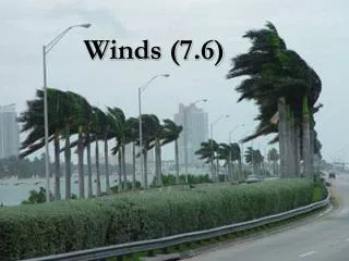
The Impact of Pressure and Wind on the Landscape • Atmospheric pressure indirectly affects the landscape • Changes manifest primarily by changes in wind and temperature • Wind has a visible component to its activity • Severe storm winds can drastically affect the landscape Figure 5-2
The Nature of Atmospheric Pressure • Gas molecules continuously in motion • Force exerted by gas molecules is called atmospheric pressure • Force exerted on every surface the gas touches • Pressure is approximately 14 lbs per square inch Figure 5-1
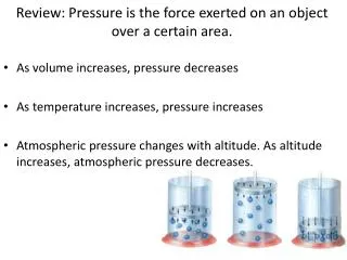
The Nature of Atmospheric Pressure • Factors influencing atmospheric pressure • Density • At higher density, particles are closer & collide more frequently, increasing pressure • Temperature • Warmer particles move faster & collide more frequently, increasing pressure Figure 5-3 Figure 4-15
The Nature of Atmospheric Pressure Figure 5-4 • Measurement of Pressure • Barometer – device to measure atmospheric pressure • Average Sea Level Pressure • 1013.25 MILLIBARS • 29.92 INCHES OF HG (MERCURY) • 14.7 LBS / SQ. INCH • 760 MM OF HG • No matter which unit of measurement is used, pressure ALWAYS decreases with altitude • Mapping pressure with isobars • Isobar: line joining points of equal pressure • Pressure gradient: horizontal rate of pressure change • Directly affects wind speed
The Nature of Wind Figure 5-5 • Wind: horizontal air movement • In theory, why does air move? • Energy imbalances on globe • Why does air actually move? • Differences in horizontal atmospheric pressure • Origination of wind • Uneven heating of Earth’s surface creates temperature & pressure gradients • Direction of wind results from pressure gradient • Winds blow from high pressure to low pressure • Winds are named for the direction they blow from!!!
The Nature of Wind • Forces which govern the wind • Pressure gradient force • Characterized by wind moving from high to low pressure, always • Winds blow at right angles to isobars • Coriolis force • Turns wind to the right in the N Hemisphere, left in S Hemisphere • Only affects wind direction, not speed, but faster winds turn more • Friction • Wind is slowed by Earth’s surface due to friction, does not affect upper levels Figure 5-7
The Nature of Wind • Force balances • Geostrophic balance • Balance between pressure gradient force and Coriolis • Winds blow parallel to isobars • Frictional balance • Winds blow slightly towards low pressure and slightly away from high pressure • Winds slowed by friction weaken Coriolis, so pressure gradient force is stronger and turns the winds Figure 5-6
The Nature of Wind • Anticyclones and cyclones Figure 5-8
The Nature of Wind • Cyclone: low-pressure cell • Air converges & ascends • Surface convergence & low pressure indicate rising motion • Rising motion results in clouds and storms • Anticyclone: high-pressure cell • Air descends & diverges • Surface divergence & high pressure indicate sinking motion • Sinking motion results in sunny skies Figure 5-9
The Nature of Wind • Wind speed • Determined by pressure gradients • Tight pressure gradients (isobars close together) indicate faster wind speeds • Wind speeds are gentle on average Figure 5-10 Figure 5-11
Vertical Variations in Pressure & Wind • Atmospheric pressure decreases rapidly with height • Atmospheric surface pressure centers lean with height • Winds aloft are much faster than at the surface • Jet streams
The General Circulation of the Atmosphere • Atmosphere is in constant motion • Major semi-permanent conditions of wind and pressure—general circulation • Principal mechanism for longitudinal and latitudinal heat transfer • Second only to insolation as a determination for global climate
The General Circulation of the Atmosphere • Simple example: Non-rotating Earth • Strong solar heating at equator • Low pressure forms over equator • Ascending air over equator • Little heating at poles • High pressure forms over poles • Descending air over poles • Winds blow equatorwardat surface, poleward aloft Figure 5-12
The General Circulation of the Atmosphere • If Earth didn’t rotate • Because Earth rotates
The General Circulation of the Atmosphere • Observed general circulation • Earth’s rotation increases complexity of circulation • Hadley cells • Complete vertical circulation cells where warm air rises, cools, moves poleward, & subsides • Around 30° N/S Figure 5-14 Figure 5-13
The General Circulation of the Atmosphere • 7 Surface Components • Intertropical convergence zone (ITCZ) (0°) • Trade winds (easterlies) (0° - 30° N/S) • Subtropical highs (30° N/S) • Westerlies (30° - 60° N/S) • Subpolar low (polar front) (60° N/S) • Polar easterlies (60° - 90° N/S) • Polar highs (90° N/S)
The General Circulation of the Atmosphere • Components of the general circulation • Subtropical highs (STH’s) • Persistent zones of high pressure near 30° N/S • Result from descending air in Hadley cells • Regions of world’s major deserts • No wind • AKA horse latitudes • Source of 2 of the 3 major wind systems: trade winds & westerlies Figure 5-16
The General Circulation of the Atmosphere • Winds are named for the direction they blow from! • Trade winds (easterlies) • Diverge from equator-ward side of STH’s • About 30°N to 30°S • SE in S Hemisphere, • NE in N Hemisphere • Blow east to west • Most reliable/consistent of wind systems • AKA Winds of commerce Figure 5-17
The General Circulation of the Atmosphere • Trade winds (cont.) • Heavily laden with moisture • Do not produce rain unless forced to rise • If they rise, they produce tremendous precipitation and storm conditions Figure 5-20
The General Circulation of the Atmosphere • Intertropical Convergence Zone (ITCZ) • Zone of rising air from surface heating & convection • Zone of low pressure & convergence toward which trade winds blow • Near equator • Constant rising motion & storminess in this region • Position seasonally shifts (more over land than water) • AKA Doldrums Figure 5-21
The General Circulation of the Atmosphere • Westerlies • Form on poleward sides of STH’s • Wind system of the midlatitudes • Blow west to east • 2 cores of high winds – jet streams • Subtropical Jet • Polar Jet • Rossby waves Figure 5-22 Figure 5-24
The General Circulation of the Atmosphere Figure 5-27 • Polar highs • Develop over poles due to extensive cold conditions • Anticyclonic winds • Strong subsidence • Arctic desert • Polar easterlies • Regions north of 60°N & south of 60°S • Winds blow east to west • Cold & dry
The General Circulation of the Atmosphere • Polar front • Low pressure around 60° N/S • Air mass conflict between warm westerlies & cold polar easterlies • Rising motion = clouds & precipitation • Very strong winds over oceans • Polar jet stream position typically coincident with the polar front • AKA subpolar low Figure 5-25
The General Circulation of the Atmosphere • 7 components of the general circulation Figure 5-26
The General Circulation of the Atmosphere • Vertical wind patterns of the general circulation • Most dramatic differences in surface and aloft winds is in tropics • Antitrade winds • Blow from SW in N Hemisphere, & from NW in S Hemisphere Figure 5-28
Modifications of the General Circulation • Seasonal modifications • 7 general circulation components shift seasonally • Components shift northward during Northern Hemisphere summer • Components shift southward during Southern Hemisphere summer Figure 5-29
Modifications of the General Circulation • Monsoons • Seasonal wind shift • Most significant disturbance of general circulation • Offshore: wind movement from land to water • Onshore: wind movement from water to land • Seasonal Winds • Wet summer • Dry winter • Develop due to: • Shift in position of ITCZ • Unequal heating of land & water Figure 5-31 Figure 5-30
Modifications of the General Circulation • Major monsoon systems Figure 5-32
Localized Wind Systems Figure 5-34 • Convectional circulation from differential heating of land & water • Sea breezes • Water heats more slowly than land during the day • Lower pressure over land, higher pressure over sea • Wind blows from sea to land • Land breezes • At night, land cools faster • Higher pressure over land, lower pressure over sea • Wind blows from land to sea
Localized Wind Systems • Convectional circulation from differential heating of higher vs. lower elevations • Valley breeze • Mountain top during the day heats faster than valley, creating lower pressure at mountain top • Upslope winds out of valley • Mountain breeze • Mountain top cools faster at night, creating higher spressureat mountain top • Winds blow from mountain to valley, downslope Figure 5-35
Localized Wind Systems • Katabatic winds • Cold winds that originate from cold upland areas • Descend quickly down mountain, can be destructive • Chinook winds • Warm downslopewinds • H pressure on windward side, L pressure on leeward side • Warms adiabatically as it moves down leeward slope of Rocky Mountains Figure 5-36
Localized Wind Systems • Santa Ana winds • Hot, dry, high speed winds • Occur in S. California from Oct to Mar • Spread wildfires in dry seasons
El Niño-Southern Oscillation • Warming of waters in the eastern equatorial Pacific • Associated with numerous changes in weather patterns worldwide • Typically occurs every 3 to 7 years for about 18 months • El Niño • Reference to the Christ Child • 1st signs usually appeararound Christmas Figure 5-37
El Niño-Southern Oscillation • Circulation patterns • Normal • El Nino • Upwelling: winds blowing offshore on W side of continents pushes water westward & brings up cold, nutrient-rich water from below Figure 5-38
Upwelling • Phytoplankton shows where upwelling occurs
El Niño-Southern Oscillation Figure 5-40 • Patterns associated with El Niño • Teleconnections • Weather effects • La Niña—opposite of El Niño • Weather effects • Circulation is similar to “normal” • Causes of El Niño • Which changes first, the atmosphere or the ocean?
El Niño-Southern Oscillation • Sea Levels & Sea Surface Temperatures during normal, El Niño & La Niña years (http://www.pmel.noaa.gov/tao/) Figure 5-39 Figure 5-C Figure 5-D Figure 5-E
Forecasting El Niño Array of 70 buoys – Galapagos Islands to New Guinea Forecasts? El Niño-Southern Oscillation Figure 5-B
Summary • Atmospheric pressure and wind affect the geographic landscape in several ways • Atmospheric pressure is the force exerted by air molecules on all objects the air is in contact with • Pressure is influenced by temperature, density, and dynamic • Isobars show areas of high pressure and low pressure • Vertical and horizontal atmospheric motions are called wind • Wind is affected by many forces • Geostrophic balance represents a balance between the Coriolis force and the pressure gradient force • Friction slows the wind and turns it towards lower pressure • Wind patterns around high and low pressure systems are anticyclonic and cyclonic, respectively • Areas of divergence at the surface are associated with sinking motion, convergence at the surface with rising motion • Close isobar spacing indicates faster winds
Summary • Winds increase rapidly with height, pressure decreases rapidly with height • The global atmospheric circulation is called the general circulation • There are seven components to the general circulation • Each component has associated weather conditions • Seasonal modifications to the general circulation exist, including monsoons • Localized wind systems affect wind direction locally on diurnal time scales • El Niño is a warming of eastern equatorial Pacific water and subsequent switching of the high and low air pressure patterns • El Niño is associated with varied weather patterns in different locations globally