Download
1 / 17
170 likes | 190 Vues
Learn about the National Geodetic Survey’s role in maintaining the NSRS, common referencing datums, and planned updates. Discover real-time network coverage and crucial guidelines.

E N D
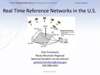
Real Time Reference Networks in the U.S. Pam Fromhertz Rocky Mountain Regional National Geodetic Survey Advisor pamela.fromhertz@noaa.gov 240-988-6363 geodesy.noaa.gov
NGS Advisors Other NGS offices geodesy.noaa.gov
National Geodetic Survey’s role • Guidelines for Real-time GNSS Networks version 2.2, 2013 NGSGuidelinesForRealTimeGNSSNetworks geodesy.noaa.gov
National Geodetic Survey’s role • Guidelines for Single Base Real Time GNSS Positioning, ver 3.1, 2014 UserGuidelinesForSingleBaseRealTimeGNSSPositioning geodesy.noaa.gov
National Geodetic Survey’s role • Guidelines for Real-time GNSS Networks • Guidelines for Single base Real time GNSS Positioning • Network validation service to align RTNs with NGS’ National Spatial Reference System. geodesy.noaa.gov
National Geodetic Survey Mission To define, maintain and provide access to the National Spatial Reference System (NSRS) to meet our Nation’s economic, social, and environmental needs. ……………………………………………......................... The NSRSis a consistent coordinate system that defines latitude, longitude, height, scale, gravity, orientation, and shoreline throughout the United States. geodesy.noaa.gov
Role of National Spatial Reference System (NSRS) • Geodetic control provides a common reference system for establishing coordinates for all geographic data. • All NSDI framework data and users' applications data require geodetic control to accurately register spatial data. • The National Spatial Reference System is the fundamental geodetic control for the United States. • A geodetic datum is an abstract coordinate system with a reference surface (such as sea level) that serves to provide known locations to begin surveys and create maps. NSRS
Common Referencing Datum in U.S. • Official horizontal datum for U.S. NAD83(2011) • Official vertical orthometric datum for U.S. NAVD88 (GEOID12B) • Others used WGS84, IGS08, ITRF08 • Historical NAD27, HARN, WGS84(1986), NGVD29 geodesy.noaa.gov
New NSRS Reference Frames/Datums Planned for 2022 • Replace NAD83 with a geocentric reference frame • GNSS based • Replace NAVD88 with a gravity based geoid • Changes in feet (in Rocky Mountains)
Puget Sound, WA Example of using the wrong Vertical References Approximately 80 meter offsets geodesy.noaa.gov
NCATNGS Coordinate Conversion and Transformation Tool geodesy.noaa.gov
Continuously Operating Reference Stations (CORS) CORS are now basis of NSRS geodesy.noaa.gov
Continuously Operating Reference Stations (CORS) CORS are now basis of NSRS geodesy.noaa.gov
U.S. Real Time Network Coverage geodesy.noaa.gov
Real Time Reference Networks in the U.S.Highlights • 17 RTNs run by state DOT: • AZ’s RTN run by AZ State Catorgraphers’ Office • Mesa County, Colorado has RTN connecting with UT • WA WSRN is a cooperative network of more than 80 partners • The North American Reference Network Operators (NARNO) is a group that address issues • Plate Boundary Observatory provides correctors geodesy.noaa.gov
Operational CORS (~1700)with 70km-buffer geodesy.noaa.gov
NOAA’s National Geodetic Survey Thank you Pam Fromhertz Pamela.Fromhertz@noaa.gov 240-988-6363 geodesy.noaa.gov Pam nor NGS endorses any manufacturer