Download
1 / 14
140 likes | 272 Vues
This engaging resource examines the critical role geography played in World War II, emphasizing that understanding the conflict requires an awareness of geographical factors such as location, territory, and strategic chokepoints. Mark Lueckenhoff offers insights and commentary on various key geographical elements that influenced military decisions and outcomes during the war. Through maps and references to significant battles and locations like D-Day, Guadalcanal, and El Alamein, this lesson highlights the importance of geography in comprehending historical events.

E N D
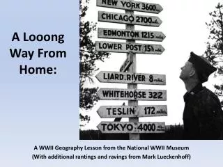
A Looong Way From Home: A WWII Geography Lesson from the National WWII Museum (With additional rantings and ravings from Mark Lueckenhoff)
Why you can’t understand WWII without GEOGRAPHY: Location, Location, Location
Why you can’t understand WWII without GEOGRAPHY: Location, Location, Location Territorial War Aims Source http://www.learner.org/biographyofamerica/prog22/maps/ Source: BBC.com Source: deepsource.worldpress.com
Why you can’t understand WWII without GEOGRAPHY: Location, Location, Location Territorial War Aims Resources Source http://www.123rf.com/photo_9421132_rubber-tree.html Source http://www.warhistoryonline.com/war-articles/veterans-of-world-war-ii-ploiesti-raid-holding-70th-reunion.html / Source http://joe-lynn.com/photoblog/wheat-field-close-up/
Why you can’t understand WWII without GEOGRAPHY: Location, Location, Location Territorial War Aims Resources Choke Points Source http://history.howstuffworks.com/american-history/panama-canal.htm Remagen Bridge Across the Rhine Source http://www.herrlichkeit-erpel.de/EnglischeVersion/Bruecke02_eng.htm El Aemain Source http://commons.wikimedia.org/wiki/File:2_Battle_of_El_Alamein_016.png D-Day Amphibious Tank Source http://www.robertsarmory.com/Utah-beach-1944.htm El Guettar Tunisia - Source: http://www.asisbiz.com/Battles/Battle-of-El-Guettar-Tunisia/pages/1-German-tank-after-the-battle-of-El-Guettar-Tunisia-01.html
Why you can’t understand WWII without GEOGRAPHY: Location, Location, Location Territorial War Aims Resources Choke Points Geographic Conditions Marines on patron at Guadalcanal Source http://www.matterhorntravel.com/2007/WWII_Pacific/ww2_pacific.htm Fording a river in New Guinea Source http://www.32nd-division.org/history/ww2/32ww2-7.html North African Desert Source http://blog.usni.org/2009/09/02/the-solomons-campaign-the-battle-of-guadalcanal-part-i Source http://www.adn.com/2008/12/28/636258/wwii-wreck-part-of-new-national.html
Why you can’t understand WWII without GEOGRAPHY: Air evacuation from the Philippines Source http://www.wired.com/science/discoveries/multimedia/2009/03/gallery_WWII_photos?slide=10&slideView=10 Location, Location, Location Territorial War Aims Resources Choke Points Geographic Conditions Distance Blood plasma on Tarawa Source http://www.wired.com/science/discoveries/multimedia/2009/03/gallery_WWII_photos?slide=7&slideView=7 B-29’s Over Mt. Fuji Source http://www.wired.com/thisdayintech/2011/03/0309incendiary-bombs-kill-100000-tokyo/ Convoy reaching Murmansk Source http://novaonline.nvcc.edu/eli/evans/HIS241/Notes/Geography/Murmansk.html
Where am I? http://www.armchairgeneral.com/forums/showthread.php?p=1950399
http://www.ddaymuseum.org/ Sign up for free newsletter https://secure3.convio.net/nw2m/site/SSurvey?JServSessionIdr004=dzbofzji47.app333b&ACTION_REQUIRED=URI_ACTION_USER_REQUESTS&SURVEY_ID=1162 Loong Way from Home Lesson Plan http://www.nationalww2museum.org/learn/education/for-teachers/lesson-plans/long-way-from-home.html Google Distance Calculator Page http://www.daftlogic.com/projects-google-maps-distance-calculator.htm
Kaiserlautern 4,813 mi. Panama Canal 2, 219 mi.
Leyte 8,238 mi.