Comprehensive Mapping System for Geospatial Symbols Categorized by Human and Natural Themes
90 likes | 192 Vues
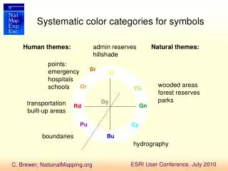
This advanced mapping system organizes symbols into systematic color categories for efficient interpretation. It includes classifications such as emergency points, schools, forest reserves, transportation networks, and administrative boundaries. Users can easily locate specific features like hospitals, wooded areas, and Native American reservations. The system employs various levels of symbols to convey information effectively, from individual points to large group layers. With detailed layers for cultural, natural, and infrastructure elements, this tool is invaluable for precise mapping and analysis.

Comprehensive Mapping System for Geospatial Symbols Categorized by Human and Natural Themes
E N D
Presentation Transcript
Systematic color categories for symbols Human themes: admin reserves hillshade Natural themes: points: emergency hospitals schools Br Yl wooded areas forest reserves parks Or YG Gy transportation built-up areas Gn Rd Pu Cy boundaries Bu hydrography
Administrative State County MCD Incorporated Place Forest Reserve Other Reserve Native American Reservation 24K… 300K…
Cultural Populated Place Schools Hospitals Churches Structure Points Locales Parks 24K… 300K…
Transportation Freeway Highway Collector Roads Local Roads Ramp 4WD, Service Railroad 24K… 800K… 300K…
MCD bdry Freeway Ramp Collector Use Symbol Levels to set merges or over-passing Incorp place bdry Local Highway
Other GNIS Springs Summits Other GNIS Physical Points Airport 24K… 300K… To>