Download
1 / 10
120 likes | 281 Vues
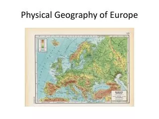
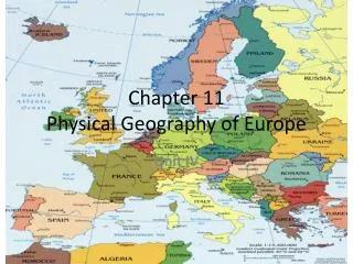
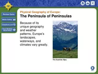
Physical Geography of Europe. Background. Stretches from the Atlantic Ocean to the Ural Mountains & from the Arctic Ocean to the Mediterranean Sea Europe can be divided into 4 landform regions: Northwest Highlands (1) Northern European Plain (2) Central Uplands (3)

E N D
Background • Stretches from the Atlantic Ocean to the Ural Mountains & from the Arctic Ocean to the Mediterranean Sea • Europe can be divided into 4 landform regions: • Northwest Highlands (1) • Northern European Plain (2) • Central Uplands (3) • Alpine Mountain System (4)
Northwest Highlands • Ancient eroded region of rugged hills & low mountains • Includes areas such as hills of Ireland & England, Scottish Highlands, mountains of Scandinavia, Northwestern France, parts of the Iberian Peninsula • During last ice age, glaciers covered the landscapes of Scandinavia & much of the British Isles • Glaciers also carved out fjords along Norway’s coast • Fjord: narrow, deep inlets of the sea set between high rocky cliffs • When the glaciers melted, the retreating glaciers left behind thin soils & thousands of lakes
Northern European Plain • Broad, coastal plain that stretches from France’s Atlantic coast all the way to the Urals • Most of the plain is 500 ft below sea level • Many rivers flow across the plain before it reaches the ocean • Region’s many rivers, short distances, & smooth terrain have long made human contact easy • Culture groups traveled, traded, & migrated through region • Today, region is Europe’s most imp farming & industrial area • Also densely populated
Central Uplands • Area of hills & small plateaus w/ forested slopes & fertile valleys • Includes the Massif Central in France & the Jura Mountains on the French/Swiss border • Region stretches northeastward across southern Germany to the Bohemian Highlands • Old eroded region • Low mountains & hills are often rounded • Productive coal regions
Alpine Mountain System • Europe’s youngest region • Includes the Alps • Stretch from France’s Mediterranean coast to the Balkan Peninsula • Some peaks reach heights of 14,000 ft • B/c of high elevation, Alps have large snowfields & glaciers • Alps have not been a serious barrier to human interaction • Other ranges in Alpine Mountain System include Carpathian Mountains in Eastern Europe, Apennines in Italy & the Pyrenees in Spain/France
Climate-Europe • Europe has 3 major climate types: • Marine west coast (1) • Humid continental (2) • Mediterranean (3) • Marine West Coast (1) • Found throughout most of northern & western Europe • Southern Iceland & the British Isles • Stretches across northern continental Europe from northern Spain into Poland & Slovakia • Rainfall averages btwn20 & 80 inches a year • Temperatures mostly mild & cloudy, drizzly/foggy
Climate-Europe continued • Humid continental (2) • Interior Norway/Sweden south to the Black Sea • Has 4 distinct seasons • Cold, snowy winters/mild-cool-humid summers • Mediterranean (3) • High mountains separate 1st two climates from Mediterranean • Most of southern Europe • 10-30 inches of rainfall a year • Rainfall usually comes in mild winters • Long, dry sunny summers
Water-Europe • Europe is nearly surrounded by water • Major bodies of water: Mediterranean Sea, North Sea, Atlantic Ocean, Arctic Ocean, Baltic Sea, etc. • Europe’s long, irregular coastline has hundreds of good natural harbors • Harbors are usually located near the mouths of navigable rivers, making Europe suitable for trade • Navigable: one that is deep enough & wide enough for shipping • Rhine & Danube Rivers are the most imp in Europe • Many cities/industrial areas located here