Comprehensive Analysis of Land Use and Property Valuation in Urban Areas
This study explores the intricate relationship between various land parcels, property values, and urban infrastructure. By employing advanced techniques such as spatial intersection and aggregation, we analyze different property attributes, including ownership details, valuation parameters, and area calculations. The findings highlight significant patterns related to urban planning, especially concerning areas exceeding 800 m², and provide insights into land utilization against topographic factors, including minimum and maximum elevation levels. This research aims to inform better land management practices and facilitate strategic urban development.

Comprehensive Analysis of Land Use and Property Valuation in Urban Areas
E N D
Presentation Transcript
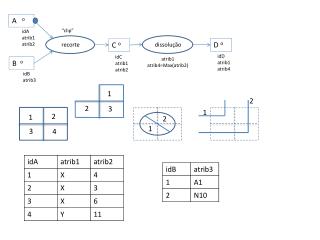
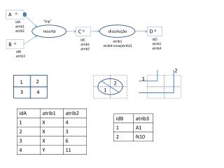
A o “clip” idA atrib1 atrib2 dissolução recorte Do C o idD atrib1 atrib4 idC atrib1 atrib2 atrib1 atrib4=max(atrib2) Bo idB atrib3 2 1 2 1 2 1 3 4
selecção dissolução Do A o Eo idA atrib1 atrib2 idD atrib1 atrib4 idC atrib1 atrib2 intersecta atrib1 atrib4=soma(atrib2) selecção B-- C -- idB atrib3 idC atrib3 atrib3=“N10” 2 1 2 1 2 1 3 4
Parcelas o ID NIF valorPatr “multipart” dissolução cruz. tabelas Parcelas 3 o Parcelas 2 o ID NIF vTotal ID NIF nomeProp valorPatr Parcelas.NIF= Proprietarios.NIF NIF vTotal=soma(valorPatr) Proprietarios o NIF nomeProp Parcelas o ID NIF valorPatr “multipart” selecção dissolução ParcelasEstrada o ID NIF valorPatr selecção intersecta Estradas -- RedeViaria -- Parcela o ID tipo ID tipo ID tipo=“estrada” Cálculo de area Parcela 2 o ID area
Povoamentos o ID selecção PovoamentosAcima600 o ID selecção Não intersecta Inferior600 o CartaHipsometrica o ID cotaMin cotaMax ID cotaMin cotaMax cotaMax≤ 600 Povoamentos o ID “multipart” dissolução recorte PovAcima800 o ID selecção Superior800 o CartaHipsometrica o PovAcima800 2 o ID cotaMin cotaMax ID cotaMin cotaMax ID cotaMin ≥800 Cálculo de area PovAcima800 3 o ID area
“multipart” dissolução Povoamentos o Povoamentos 2 o ID Data ID dataPlantacao Data=max(dataPlantacao) Povoamentos o “multipart” ID dataPlantacao intersecção dissolução PovoamentosCotas 2 o PovoamentosCotas o ID COTA ID dataPlantacao cotaMin cotaMax COTA=max(cotaMAX) CartaHipsometrica o ID cotaMin cotaMax
FOV/2 IFOV y x