Update on UU WRF Numerical Modeling
80 likes | 236 Vues
Update on UU WRF Numerical Modeling. Goals: characterize (1) Boundary-layer structure and flows (2) I nteractions between cold air pool and large-scale weather systems Work completed : 1-7 February 2013 WRF simulation with and without snow, initial visualizations Future work :

Update on UU WRF Numerical Modeling
E N D
Presentation Transcript
Update on UU WRF Numerical Modeling • Goals: characterize (1) Boundary-layer structure and flows (2) Interactions between cold air pool and large-scale weather systems • Work completed: 1-7 February 2013 WRF simulation with and without snow, initial visualizations • Future work: --Erik Neemann M.S. thesis. Extend to Feb 10th and re-run using same domain and set-up as DEQ. Further visualization, validation against observations, include tracers. --Gain insight into cross-basin elevated flows and interactions between land use (snow cover) and near-surface flows
Animation WRF simulations 1-2 Feb Westerly ‘Partial Mix-Out’ of PCAP
Sensitivity to Snowcover Snow No Snow
00Z 1 Feb 2013 NAM snow depth initialization Domain 3 Topography 22 to 28 cm (large overestimation in west side of basin) /uufs/chpc.utah.edu/common/home/u0818471/pcaps_wrf/WPS
00Z 1 Feb 2013 Domain 3 Modified Snow Cover Domain 1 Modified Snow Cover 12 cm 12 cm /uufs/chpc.utah.edu/common/home/horel_data/eneemann/Uintah_Basin_Runs/Feb_2013_snow
2 February 2013 1836 UTC Landsat 7 ETM+ (60 m resolution) patchy snow Warmer skin surface Visible Skin temperature
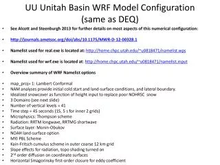
Preliminary UU Unitah Basin WRF Model Configuration (will be modified to be same as DEQ at WRF meeting) • See Alcott and Steenburgh 2013 for further details on most aspects of this numerical configuration: • http://journals.ametsoc.org/doi/abs/10.1175/MWR-D-12-00328.1 • Namelist used for real.exe is located at: http://home.chpc.utah.edu/~u0198116/ubos/namelist_wps • Namelist used for wrf.exe is located at: http://home.chpc.utah.edu/~u0198116/ubos/namelist.input • Overview summary of WRF Namelist options • map_proj= 1: Lambert Conformal • NAM analyses provide initial cold start and land-surface conditions, and lateral boundary. • Idealized snowcover as function of height input to replace poor NOHRSC snow • Domain (see next slide) • Number of vertical levels = 109 • Time step = 45 seconds (15, 5 s for inner 2 grids) • Microphysics: Thompson scheme • Radiation: RRTM longwave, RRTMG shortwave • Surface layer: Monin-Obukov • NOAH land-surface option • YSU PBL Scheme • Kain-Fritsch cumulus scheme in outer coarse 12 km grid • Slope effects for radiation, topo shading turned on • 2nd order diffusion on coordinate surfaces • Horizontal Smagorinsky first-order closure for eddy coefficient
Preliminary Domains 2 - Middle (4.05km) 1 - Outer (12.15km) 3 - Inner (1.35km)