Download
1 / 1
10 likes | 158 Vues
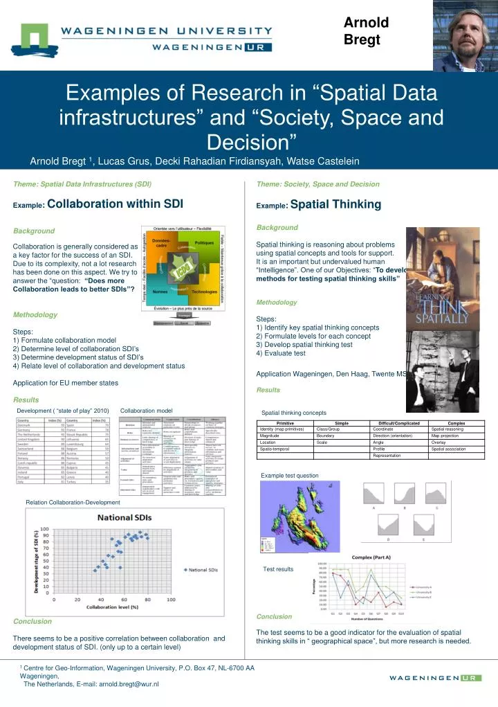
Arnold Bregt. Examples of Research in “ Spatial Data infrastructures” and “Society, Space and Decision” . Arnold Bregt 1 , Lucas Grus, Decki Rahadian Firdiansyah , Watse Castelein. Theme: Spatial Data Infrastructures (SDI) Example : Collaboration within SDI Background

E N D
Arnold Bregt Examples of Research in “Spatial Data infrastructures” and “Society, Space and Decision” Arnold Bregt 1, Lucas Grus, Decki RahadianFirdiansyah, Watse Castelein Theme: Spatial Data Infrastructures (SDI) Example: Collaboration within SDI Background Collaboration is generally considered as a key factor for the success of an SDI. Due to its complexity, not a lot research has been done on this aspect. We try to answer the “question: “Does more Collaboration leads to better SDIs”? Methodology Steps: 1) Formulate collaboration model 2) Determine level of collaboration SDI’s 3) Determine development status of SDI’s 4) Relate level of collaboration and development status Application for EU member states Results Conclusion There seems to be a positive correlation between collaboration and development status of SDI. (only up to a certain level) • Theme: Society, Space and Decision • Example: Spatial Thinking • Background • Spatial thinking is reasoning about problems • using spatial concepts and tools for support. • It is an important but undervalued human • “Intelligence”. One of our Objectives: “To develop • methods for testing spatial thinking skills” • Methodology • Steps: • 1) Identify key spatial thinking concepts • 2) Formulate levels for each concept • 3) Develop spatial thinking test • 4) Evaluate test • Application Wageningen, Den Haag, Twente MSc’s • Results • Conclusion • The test seems to be a good indicator for the evaluation of spatial thinking skills in “ geographical space”, but more research is needed. • 2) Collaboration model Development ( “state of play” 2010) Spatial thinking concepts Example test question Relation Collaboration-Development Test results 1 Centre for Geo-Information, Wageningen University, P.O. Box 47, NL-6700 AA Wageningen, The Netherlands, E-mail: arnold.bregt@wur.nl