Enhancing Emergency Response for Badger Mountain: A Proactive Approach
Over the last six months, RFD has collaborated with Benton County Parks/Rec, Friends of Badger Mountain, and BCFD#1 to improve emergency medical services (EMS) and fire response capabilities on Badger Mountain, which saw over 170,000 visitors in 2012. Challenges identified include accessibility for ambulances, manpower issues during rescues, and callers’ lack of knowledge about locations. Solutions include updated run cards, pre-staging of equipment, and the installation of trail markers to improve response times and efficiency in locating patients.

Enhancing Emergency Response for Badger Mountain: A Proactive Approach
E N D
Presentation Transcript
WHAT’S BEEN GOING ON • For the past six months, RFD has worked with Benton County Parks/Rec, Friends of Badger Mountain, and BCFD#1 • Looking for ways to improve our EMS and fire response to the mountain
Popularity is Soaring! • Estimated that over 170,000 people climbed mountain in 2012 • Increase of 50,000 from 2011
Impact to Fire/EMS • Increase in calls for service • 6 calls in 2012 • 1 working code in 2010, in addition to other calls • Potential for increase in call volume
Problems Identified(Access) • Service Road is accessible by ambulance • Many of the trails, however, are not • 4x4 vehicle needed
Problems Identified(Manpower) • Takes several hands to carry someone off trail • Due to accessibility, fatigue will happen quickly • Do current run cards account for this? • NO!
Types of Calls • Chest pain • Shortness of breath • Slips, Trips, Falls • Heat/Cold Injuries • Bicycle Wrecks • Dog Bites • Snake Bites • Anaphylactic Reaction • Diabetic • Other Medical/Trauma • Fire
Why the Big-to-Do Now?? • Because we are behind the 8-ball • Shift in fire/ems from reactive to proactive • Pre-planning is a must • Will help mitigate future calls for service
Problems Identified(Caller doesn’t know location) • Have had several instances of this • Event on 8/16/12 • Chest pain call • 20 minutes to locate • Contrary to popular belief, dispatch cannot GPS location using cell phone • Washington State Emergency Management • FCC 911 Guidelines
Problems Identified(Weather) • Safety factor for hikers and responders • Will make access more difficult • May exclude landing of MedStar
Problems Identified(Increased Popularity) • Number of people using mountain goes up every year • Also a good thing!! • Badger South Development • Larger range of age-groups making hike
What is the Solution?(Access) • Become familiar with the trails and access points • Updated maps in MDT’s • MedStar • Predetermined LZ’s
What is the Solution?(Manpower) • Updated run cards • Increase in number of personnel responding • Pre-staging of equipment • Rescue Litter and Rescue Mule Litter Wheel at top and bottom of mountain
What is the Solution?(Caller unaware of location) • Mile markers and Signposts • “People often don’t pay attention to the trailmarkers” ~Larry Nunez, Phoenix Fire • Lifesaving value is real • Scottsdale, AZ McDowell Sonoran Preserve • Could become trend/serve as example: • As Benton County works to create countywide trail and path network • Parks and Rec Master Plan
UPDATED RUN CARDS • Badger Mountain has been listed as a special address at SECOMM • There are three addresses listed for mountain • 5305 East 210 PR NE, Richland, WA • This is off of Dallas Road • 525 QueensgateDr, Richland, WA • Also known as Trailhead Park • @West end of Bermuda Rd • New run cards will add more staff and appropriate off-road capable apparatus • Also puts MedStar on standby • At a minimum you will get 9 personnel responding
PRE-STAGING OF EQUIPMENT • Rescue Litter • Benton County purchased two (2) rescue litters • BCFD1 and BCFD2 donated Stokes Baskets • The combination will improve patient transport • Equipment will be staged in two (2) locations • At the base of the hill at 525 Queensgate Drive • Will be located in the bathroom in Trailhead Park • At the top of the hill in the repeater tower building • The building is the one on the far east
HOW TO GET IN THESE BUILDINGS • Supra-S boxes will be staged on both buildings • One will also be staged at gate on service road off of Dallas Rd • Key/Combination will be located inside each box to allow entry • Code for boxes is “R-F-D”
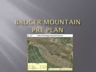
LOCATING THE PATIENT • Each trail will have individualized trail markers spaced every .25 miles • Markers will be color-coded and numbered • When call is made to 911, caller will be able to identify the trail marker, providing the color and number to dispatch • So… how does this help us?
LOCATING THE PATIENT • Each trailmarker will be GPS-located • A map, with trailmarkers, will be uploaded in our MDT’s • Dispatch will be able to provide us with the trailmarker location, and we will be able to tell the exact location of the injured person • Will allow us to determine best access point • Will save valuable minutes and allow care to start sooner
LANDING ZONE/REFERENCE POINT MAP • That last picture didn’t come through very well. • We apologize. • There will be a better picture on the MDT
DISPATCH RESPONSIBILITIES • As stated in previous slide, there will be trailmarkers that are color-coded with corresponding numbers on them • You will be provided with a map containing these markers, and the corresponding locations • Please prompt the callers with the following information after they identify that they are on Badger Mountain: • Tell them to look on the trail for a marker • The marker may be in front of them or behind them • The markers are spaced every .25 miles • Ask them to identify the color of the marker and the number that is listed • Relay that information to responding units so we can pinpoint their location and identify best access
RESPONDER RESPONSIBILITIES • Determine location based upon milepost and color of trailhead. • Dispatch the proper apparatus to the pre-determined locations for the quickest patient access • Based upon patient condition put MedStar on Stand-by or Launch. • 1st arriving apparatus, gather litter from summit or base and go to patient. • Additional resources stage at pre-determined location and communicate needs to the patient crew.
RESPONDER RESPONSIBILITIES • Identify best route for evacuating patient uphill or downhill. • Get medic units to the patient evacuation area. • Use tactical radio channels if necessary (think of topography and tac channel limitations –vs- geographic channels) • Establish an IC to coordinate rescue/care • If landing MedStar identify a lead person to communicate landing and ensure a clear zone at the LZ.
WHAT ELSE… • The plan also includes a public information piece to educate the hiking public. • We will have new signs at the trailheads • Fire danger signs will be posted • Possibility of having PSA’s and announcement in utility bills • In the future we are looking at an Early Alert System for fires on the mountain • Also examining the possibility of establishing “safety zones” on the mountain in the event of a fire
MOST IMPORTANT… • Get your hands on the equipment • Practice with it • Put someone in the basket • If you can… hike the mountain to become familiar with the trails • Questions? E-mail Duncan or Hardgrove