Why We Exist
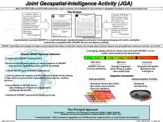
Joint Geospatial-Intelligence Activity (JGA). NGA, USSTRATCOM and USJFCOM partnership to seek a common, joint capability for the provision of geospatial intelligence to the lowest tactical level. Why We Exist.

Why We Exist
E N D
Presentation Transcript
Joint Geospatial-Intelligence Activity (JGA) NGA, USSTRATCOM and USJFCOM partnership to seek a common, joint capability for the provision of geospatial intelligence to the lowest tactical level Why We Exist “…warfighter requires the most up-to-date and highest resolution geospatial intelligence data to form a highly accurate common operational picture and to guarantee C2, ISR and mission preparation systems are interoperable.” Adm Giambastiani “I propose JFCOM and NGA together sponsor an activity that…brings the services and commands together to seek a common, joint capability for the provision of geospatial intelligence to the last tactical mile. Lt Gen Clapper A partnership to provide GEOINT in a multi-directional, standards-based environment; leveraging emerging net-centric, warfighter enterprises compatible with COCOM, Service and Agency systems. GEOINT: Exploitation and analysis of imagery and geospatial information to describe, assess and visually depict physical features and geographically referenced activities on the Earth. Leveraging ongoing efforts to collect, fuse and share GEOINT in a net-centric environment at the tactical level Common GEOINT Gaps to be Addressed FY06 FY07 FY08 FY09 FY10 FY011 . . . . . . . • Limited Joint GEOINT Doctrine/SOPs • Personnel insufficiently trained on various aspects of GEOINT • data sources, capabilities, tools, general knowledge • Limited GEOINT personnel and organizations • Lack of commercial imagery and FDO process inhibits timely sharing of data with non-government organizations, host nations, coalition partners • Inaccessibility to GEOINT due to: • data residing on multiple security domains • inadequate bandwidth • Insufficient GEOINT requirements tracking process Near-term Mid-term Long-term GEOINT Cell and Process Definitions Integrated Geospatial Operations and Intelligence Strategic Implemen- tation Plans to enable value-added data Integration Assessment Interoperability Implementation Profiles • Enterprise Service Bus (SOA) • Net-centric environments • Exercise Validation • Standards • Architectures TRIDENT WARRIOR 06/07 STRONG ANGEL III • Two Pronged Approach • “Quick Wins” - draft/test Joint Warfighter Integrated GEOINT (JWIG) CONOPs • validation via exercise participation, experimentation (JSIC, GIAT, etc.) • “Lasting Changes” - NSG community engagement via COCOM surveys; supports follow-on requirements documentation UNCLAS//FOUO LAST UPDATED: 17 AUG 06