Download
1 / 31
310 likes | 339 Vues
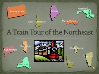
The A-Train. Presentation Schedule. 11/25 (Tuesday): Clouds and Climate Nick Mangieri-- Noctilucent clouds using CloudSat (15-minutes) Allison Marquardt--The Earth Radiation Budget Experiment (15-minutes) Ross Alter -- MODIS / Atmosphere (15-minutes)

E N D
Presentation Schedule 11/25 (Tuesday): Clouds and Climate Nick Mangieri-- Noctilucent clouds using CloudSat (15-minutes) Allison Marquardt--The Earth Radiation Budget Experiment (15-minutes) Ross Alter -- MODIS / Atmosphere (15-minutes) Lynn DiPretore -- Raman Lidar (15-minutes) 12/2 (Tuesday): Biological Oceanography Chris Devito, Rob Reale, Antonio Riggi -- Sea Surface Temperature and Phytoplankton (30-minutes) Emily French -- Phytoplankton and ENSO Nicole Mentel -- Satellite Detection of Oil Spills (15-minutes) Americo DeLuca -- Satellite Remote Sensing of Titan and the early Atmosphere of Earth (15-minutes) 12/4 (Thursday): Weather Detection Reynir Winnar and Steve Sekula -- Severe Weather Detection (20-minutes) Geoffrey Grek -- Mobile Tornado Radars (15-minutes) Justin Godynick -- Sea Ice Detection by Satellite (15-minutes) 12/9 (Tuesday): Remaining presentations
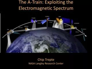
A-TRAIN CONSTELLATION The Afternoon or "A-Train" satellite constellation presently consists of 5 satellites; NASA's Aqua and Aura satellites, CNES' PARASOL satellite, and the CALIPSO and CloudSat satellites inserted in orbit behind Aqua in April 2006. Two additional satellites, OCO and Glory, will join the constellation in late 2008. Approx equator crossing times
The satellites in the A-Train are maintained in orbit to match the World Reference System 2 (WRS-2) reference grid used by Landsat. CloudSat and CALIPSO travel within 15 seconds of each other so that both instrument suites view the same cloud area at nearly the same moment. This is crucial for studying clouds which have lifetimes often less than 15 minutes. The constellation has a nominal orbit altitude of 705 km and inclination of 98o. Aqua leads the A-train with an equatorial crossing time of about 1:30 pm. CloudSat and CALIPSO lag Aqua by 1 to 2 minutes separated from each other by 10 to 15 seconds.
The World Reference System 2 (WRS-2) was developed to facilitate regular sampling patterns by remote sensors in the Landsat program. Landsat-7 and Terra are “morning” satellites in the same orbit as the A-train. Each satellite completes 14.55 orbits per day with a separation of 24.7 degrees longitude between each successive orbit at the equator. The orbit tracks at the equator progress westward 10.8 degrees on succeeding days, which over a 16-day period produces a uniform WRS grid over the globe. The WRS grid pattern of 233 orbits with separation between orbits at the equator of 172 km. The Aqua satellite will be controlled to the WRS grid to within +/- 10 km.
17:40 UTC = 12:40 pm EST 20:55 UTC = 12:55 pm PST
The World Reference System 2 (WRS-2) was developed to facilitate regular sampling patterns by remote sensors in the Landsat program. Landsat-7 and Terra are “morning” satellites in the same orbit as the A-train. Each satellite completes 14.55 orbits per day with a separation of 24.7 degrees longitude between each successive orbit at the equator. The orbit tracks at the equator progress westward 10.8 degrees on succeeding days, which over a 16-day period produces a uniform WRS grid over the globe. The WRS grid pattern of 233 orbits with separation between orbits at the equator of 172 km.
The heart of Formation Flying, as it is called, is control boxes. The satellites are allowed to drift inside control boxes until they approach the boundaries of the box, then maneuvers are initiated to adjust the orbit. This is crucial both to maintain the observing times and geometries of the instruments, but especially to avoid collisions, which would produce a debris field that would threaten the entire formation.
Aqua is kept inside a control box of ±21.5 seconds (about ±158 km) so that it makes precisely 233 complete orbits in 16 days (WRS-2 grid). CALIPSO is maintained in a ±21.5 second control box averaging 73 seconds, about 547 km, behind Aqua, so CALIPSO is never closer than 30 sec(225 km) to Aqua. Parasol flies about 131 seconds behind Aqua, and Aura flies about 900 seconds behind Aqua. CloudSat flies in a mini formation 12.5±2.5 seconds aheadof CALIPSO. The satellites are controlled by different agencies: Aqua and Aura by NASA/Goddard, CloudSat by US Air Force, PARASOLby CNES, and CALIPSO by NASA/Langley and CNES. Horizontal separation is another aspect of Formation Flying. The first four A-Train satellites fly in tight formation so they view the same locations from above in a brief time span. Aura is positioned substantially behind the others such that its Microwave Limb Sounder views horizontally the same portion of the atmosphere that Aqua views from above.
Aura CALIPSO OCO Aqua Glory CloudSat PARASOL OCO - CO2 column OMI - Cloud heights OMI & HIRLDS – Aerosols MLS& TES - H2O & temp profiles MLS & HIRDLS – Cirrus clouds CALIPSO- Aerosol and cloud heights Cloudsat - cloud droplets PARASOL - aerosol and cloud polarization OCO - CO2 MODIS/ CERES IR Properties of Clouds AIRS Temperature and H2O Sounding (Source: M. Schoeberl) Afternoon Constellation Coincidental Observations
CALIPSO • Joint NASA/CNES satellite • Three instruments: • Cloud-Aerosol Lidar with Orthogonal Polarization (CALIOP): Two wavelength polarization-sensitive Lidar that provides high-resolution vertical profiles of aerosols and clouds • Wide Field Camera (WFC): Fixed, nadir-viewing imager with a single spectral channel covering the 620-670 nm region • Imaging Infrared Radiometer (IIR): Nadir-viewing, non-scanning imager
94 GHz 35 GHz Maximum Propagation Distance Energy Absorbed by Atmosphere 10-15 km 20-30 km 3.2 mm 8 mm Radar Wavelength
CloudSat • NASA satellite with the Cloud Profiling Radar (CPR) instrument, a 94-GHz nadir-looking radar • Measures the power backscattered by clouds as a function of distance from the radar. • Developed jointly by NASA’s Jet Propulsion Laboratory (JPL) and the Canadian Space Agency (CSA). • Will advance our understanding of cloud abundance, distribution, structure, and radiative properties. • First satellite-based millimeter-wavelength cloud radar • > 1000 times more sensitive than existing ground weather radars • Able to detect the much smaller particles of liquid water and ice (ground-based weather radars use centimeter wavelengths) Cloud Profiling Radar
Radar/Lidar Combined Product Development • Formation flying is a key design element in cloudsat • CloudSat has demonstrated formation flying as a practical observing strategy for EO. • Overlap of the CloudSat footprint and the CALIPSO footprint, within 15 seconds, is achieved >90% of the time.
lidar/radar combined ice microphysics - new A-Train ice cloud microphysics Preliminary example from Zhien
A-train Cloud ice MLS ECMWF CloudSat
Microwave Absorption (Opacity) in Arctic (Westwater et al., 2006)
EOS Aura Researches the composition, chemistry, and dynamics of the Earth’s atmosphere as well as study the ozone, air quality, and climate. Instruments • HIRDLS: High Resolution Dynamics Limb Sounder – Observes global distribution of temperature and composition of the upper troposphere, stratosphere, and mesosphere • MLS: Microwave Limb Sounder – Uses microwave emission to measure stratospheric temperature and upper tropospheric constituents • OMI : Ozone Monitoring Instrument – Distinguishes between aerosol types, such as smoke, dust, and sulfates. Measure cloud pressure and coverage, which provide data to derive tropospheric ozone. • TES: Tropospheric Emission Spectrometer – High-resolution infrared-imaging Fourier transform spectrometer that offers a line-width-limited discrimination of essentially all radiatively active molecular species in the Earth's lower atmosphere.
HIRDLS • multi-channel, microwave radiometer • radiated thermal emissions from the atmospheric limb • spectral intervals in the range (6 to 17) mm, chosen to correspond to specific gases and atmospheric "windows". • global 3-D fields of atmospheric temperature, several minor constituents, and geostrophic winds.
Microwave Limb Sounder (MLS) • The EOS MLS measures thermal emission from broad spectral bands centered near 118, 190, 240, 640 and 2250 GHz
OMI : Ozone Monitoring Instrument The OMI instrument can distinguish between aerosol types, such as smoke, dust, and sulfates, and measures cloud pressure and coverage, which provide data to derive tropospheric ozone.
TES: Tropospheric Emission Spectrometer • Example of TES products