Download
1 / 67
850 likes | 1.42k Vues
Elements of a Typical Cross-section of Road and Highway drainage. Transportation Engineering – I Dr. Attaullah Shah. Road. A way or path over which cyclists, vehicles and pedestrians can pass lawfully. Roads are normally used for transportation within a country. Advantages of Roads.

E N D
Elements of a Typical Cross-section of Road and Highway drainage Transportation Engineering – I Dr. Attaullah Shah
Road • A way or path over which cyclists, vehicles and pedestrians can pass lawfully. • Roads are normally used for transportation within a country.
Advantages of Roads • Nearest to the man, as for going to airport, harbor or railway station. • Can be used by all types of vehicles from cycles to trailers. • Can lead to any remote area and road users have freedom of movement. • Vehicle movements are not time bound, roads are open to traffic for 24 hours.
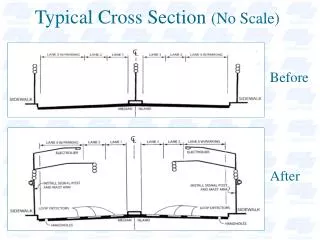
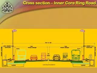
Cross-Section Elements The cross section of a road includes some or all of the following elements: • Traveled way • Roadway • Median • Shoulder • Kerb • Traffic Barriers • Bicycle and pedestrian facilities • Drainage channels and side slopes
Selection of appropriate cross-section elements In selecting the appropriate cross-section elements and dimensions, designers need to consider a number of factors: • Volume and composition (percent trucks, buses, and recreational vehicles) of the vehicular traffic expected to use the facility • The likelihood that cyclists and pedestrians will use the route • Climatic conditions
Selection of appropriate cross-section elements • The presence of natural or human made obstructions adjacent to the roadway (e.g., rock cliffs, large trees, wetlands, buildings, power lines) • Type and intensity of development along the section of the highway facility that is being designed • Safety of the users The most appropriate design is the one that balances the mobility needs of the people using the facility (motorists, pedestrians, or cyclists) with the physical constraints of the corridor within which the facility is located.
Right of Way • The right of way can be described generally as the publicly owned area of land that encompasses all the various cross-section elements. • The right of way is the land set aside for use as a highway corridor. • Rights of way are purchased prior to the construction of a new road, and usually enough extra land is purchased. • Sometimes, rights of way are left vacant after the initial roadway facility is constructed to allow for future highway expansion.
Right of Way Requirements of area for right of way are as follows: • For 2 lane road = 150 ft width of area • For 4 lane road = 250 ft width of area • For 8 lane road = 300 ft width of area
Traveled Way or Carriage Way • The portion of the roadway provided for the movement of vehicles, exclusive of shoulders. • Number of lanes on a traveled way are decided on the basis of expected traffic volumes and appropriate level of service required for the facility.
Traveled Way or Carriage Way • Lane width strongly influences traffic safety and comfort • Lane width ranges from 2.7-3.6 m with 3.6 m lane predominant on high-type highways • Two-lane two-way highways with the 3.6 m lane provide safe clearance between large commercial vehicles
Dual Carriage Way When traffic volumes are quite heavy, carriageway may be divided into two parts by providing a median strip and each portion of the carriage way is reserved for traffic moving in opposite direction.
Road Way • The portion of a highway provided for vehicular use. • It includes both carriageway and shoulders.
Formation Width • It is the sum of widths of carriage way, shoulders and median strips if provided. • In case of embankments, it is measured as the top width. • In case of cutting, it is the bottom width of the cutting from which side drains are excluded.
Shoulders • Shoulders are the strips provided on both sides of the carriage way.
Functions of shoulders • accommodation of stopped vehicles (disabled vehicles, bus stops) • emergency use • lateral support for the pavement • space for roadside facilities • space for bicycles and pedestrians • driving comfort (freedom from strain) • improvement in sight distance • improvement in capacity
Width of shoulders • Low-type roads -- minimum 0.6 m, recommended 1.8-2.4 m • Shoulder provided for bicycles -- minimum 1.2 m wide • High-type roads -- minimum 3.0 m, recommended 3.6 m • Shoulders should be continuous. • Shoulders on bridges should have the same width as on the approach sections.
Median or Traffic Separators • It is the physical or painted separation provided on divided highways between two adjacent roadways. • Medians can also be used to isolate slow and fast moving traffic in the same direction. • Width of medians ranges from 1.2 to 24 m.
Function of medians • separate opposing traffic • recovery area for out-of-control vehicles • stopping area • storage of right-turning and U-turning vehicles • minimize headlight glare • provision for future lanes
Kerb • It is the dividing line between carriageway and footpath.
Functions of Kerbs • drainage control • roadway edge delineation • right-of-way reduction • delineation of pedestrian walkways • reduction in maintenance operation • Assistance in roadside development
Types of Kerbs • Class I Kerb: Height 7-9 cms • Class II Kerb: Height 15-20 cms • Barrier: 23-45 cms • Submerged: provide lateral stability
Foot Path or side Walk • Foot paths are provided in Urban roads • These are raised strips constructed along both the edges of roads. • Their minimum recommended width is 1.3 m.
Bicycle and Parking lane • Bicycle lane is a portion of the roadway designated by striping, signing, and/or pavement markings for preferential or exclusive use by bicycles and/or other non-motorized vehicles. • Parking lane is an additional lane provided on Urban roads and streets for on-street parking.
Bicycle and Parking lane Minimum Width Requirements
Traffic Barriers A longitudinal barrier, including bridge rail, or an impact attenuator used to • Redirect vehicles from hazards located within an established Design Clear Zone • To prevent median crossovers • To prevent errant vehicles from going over the side of a bridge structure • To protect workers (occasionally) • To protect pedestrians, or bicyclists from vehicular traffic
Drainage Channels and Side slopes • Drainage channels and side slopes are provided along the length of road for storm water drainage etc.
Drainage Channels and Side slopes Drainage channels should: • have adequate capacity for the design runoff, • minimize damage to the highway caused by unusual storm water, • minimize risk for motorists, • be resistant to the high speed water flows where expected, • prevent sedimentation of the particles carried by water.
Drainage Channels and Side slopes Side slopes should • insure the stability of the roadway • provide opportunity for recovery of an out-of-control vehicle
Part 2 Highway Drainage Transportation Engineering - I
Highway Drainage • A means by which surface water is removed from pavement and ROW • Redirects water into appropriately designed channels • Eventually discharges into natural water systems
Inadequate Drainage • Damage to highway structures • Loss of capacity • Visibility problems with spray and retro-reflectivity • Safety problems, reduced friction and hydroplaning
Highway Drainage • Transverse slopes • Removes water from pavement surface • Facilitated by cross-section elements (cross-slope, shoulder slope) • Longitudinal slopes • Minimum gradient to maintain adequate slope in longitudinal channels • Longitudinal channels • Ditches along side of road to collect surface water after run-off
Drainage System Three phases • To Estimate the quantity of water to reach the system • Hydraulic design of system elements • Comparison of different materials to serve the purpose Steep slopes provide good hydraulic capacity and lower ROW costs, but reduces safety and increases erosion and maintenance costs
Hydrologic Analysis Q = CIA (english) or Q = 0.0028CIA (metric) Q = runoff (ft3/sec) or (m3/sec) C = coefficient representing ratio or runoff to rainfall I = intensity of rainfall (in/hour or mm/hour) A = drainage area (acres or hectares)
Transverse Slope Undivided traveled ways (two- and multilane) on tangents and flat curves have a crown in the middle and slope downward toward both edges (camber). The downward cross slope may be a plane or rounded section (parabolic), or a combination of the two. One-way traveled ways on divided highways may be crowned separately or may have a unidirectional cross slope/cross fall.