Download

1 / 3
0 likes | 7 Vues
Leadtech Consulting has years of experience in GIS mapping and geo-tagging across India. They support governments and businesses by using GIS mapping services, GPS, mobile apps, and data tools to turn location information into insights. Their projects include mapping cold storage units and infrastructure for major clients. Their solutions work even with low internet and are tailored for education, small businesses, and the environment to support better decisions. For more information, visit: https://leadtech.in/gis-mapping-services-that-power-real-time-decisions<br>

E N D
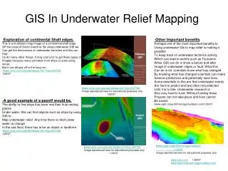
Leadtech Consulting: Key Leadtech Consulting: Key Roles and Strengths in Roles and Strengths in GIS Mapping Services GIS Mapping Services Role and Key Strengths in GIS Mapping Services 1. The Growing Importance of Accurate Location Data In today’s world, precise spatial information is crucial across diverse sectors, from city planning to rural welfare initiatives. Success increasingly depends on understanding “where” things are, making GIS mapping an indispensable tool for effective decision- making. 2. Leadtech Consulting: A Trusted GIS Partner for 16+ Years With over 16 years of experience and more than 200 successful projects, Leadtech Consulting Pvt. Ltd. has become a leader in India’s GIS web mapping and geo-tagging landscape, supporting government, corporate, and research-driven initiatives. 3. Beyond Mapping: Integrating Technology and Insight
Leadtech’s strength lies not only in advanced technology but also in their holistic approach. Their GIS services combine precision GPS, mobile applications, and powerful analytics to deliver insights that reveal what’s working, what’s needed, and what comes next. 4. Real-World Impact: Notable Projects NABCONS Cold Storage Geo-Tagging: Over 22,000 cold storage units mapped with detailed photographs, structural data, and usage analysis. Coal India Ltd. Infrastructure Mapping: Comprehensive geo-tagging of equipment and personnel across 35 sites, feeding into ESG management dashboards. 5. Technical Expertise & Field-Ready Solutions Leadtech’s platforms are designed to function seamlessly even in low-connectivity areas. Utilizing technologies such as Python, R, spatial databases, drones, and GPS trackers, they transform raw field data into actionable intelligence. 6. Customized GIS Solutions for Diverse Sectors Leadtech tailors GIS solutions to sector-specific needs: Education: School infrastructure databases MSMEs: Cluster and logistics gap analysis Environment: Aerial surveys combined with ground audits This flexibility ensures clients receive relevant, impactful spatial insights. 7. The Future of Location Intelligence As demand grows for real-time, geo-tagged infrastructure visualization and data-driven decision tools, Leadtech stands out by providing scalable, PAN-India GIS services backed by a skilled and responsive team, enabling clients to stay ahead in an increasingly spatial world.
Contact Information 9650060882 leadtech.in Info@leadtech.in