Download
1 / 20
210 likes | 336 Vues
The Interplay between a Mountainous River and Nearby Submarine Canyon in Southern Taiwans. Ray T. Hsu and James T. Liu Institute of Marine Geology and Chemistry, National Sun Yat-sen University, Kaohsiung, Taiwan 804-24. Mediterranean sea. Hudson Submarine Canyon. Monterey Submarine Canyon.

E N D
The Interplay between a Mountainous River and Nearby Submarine Canyon in Southern Taiwans Ray T. Hsu and James T. Liu Institute of Marine Geology and Chemistry, National Sun Yat-sen University, Kaohsiung, Taiwan 804-24
Mediterranean sea Hudson Submarine Canyon Monterey Submarine Canyon La Jolla Submarine Canyon Kaikoura Canyon Submarine Canyons are Everywhere on This Planet!
Study Area Taiwan Taiwan Strait Kaoping Submarine Canyon Pacific Ocean South China Sea
Study Area Drainage area: 3,275 km2 Mean annual runoff: 8.46*109 m3 Annual sediment discharge: 3.61*107 M.T.
Field Survey June 19 – July 20, 2000
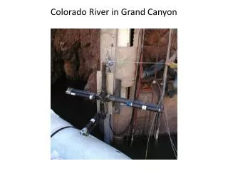
Trap Array and Tripod Tripod
Suspended Sediments Captured in Traps and SSC Measured from LISST-100)
Discussion • Coastal impact by kai-tek typhoon. • The sand fraction in the suspended sediment concentration (SSC) in the canyon came from the shelf floor above and has the highest correlation with the river sediment discharge. • Clay composes the largest fraction of SSC in the canyon.
Coastal Impact by Kai-tek Typhoon SSC and Wave Field at Kaoping River Mouth
Sand in The Submarine Canyon Sand Fall in San Lucas Submarine Canyon
Conclusion (1) High mountainous rivers located in the tropical and subtropical regions of the world whose runoff and sediment content (sediment load) display: • Distinct dry and flood seasons in their annual hydrological cycle • The range of magnitude can span several orders of magnitude • the extreme values in the runoff and sediment content are controlled by episodic events that mostly occur in the summer (flood season)
Conclusion (2) • The largest fraction in SSC in Kaoping Submarine Canyon (KPCY) is from clay to very fine grains. • The role of the KPCY is an important conduit for sediments from the river to the ocean, especially in episodic events, such as typhoons