Download
1 / 27
270 likes | 376 Vues
Join the stakeholders meeting on November 7, 2008, in Santa Rosa to discuss ASBS monitoring, regional planning, and reference sites. Explore the natural water quality focus on wet weather impacts and shoreline conditions. Take part in the three-phase approach to define natural water quality limits and assess ASBS impacts in Southern California. Learn about monitoring constituents and sampling criteria to improve water quality assessments. Collaborate on rocky intertidal and subtidal monitoring for a comprehensive understanding of water quality parameters.

E N D
State Water Resources Control Board ASBS Monitoring Stakeholders MeetingSanta Rosa, CANovember 7, 2008 Regional Monitoring Planning and Consideration of Reference Sites in Central and Northern California
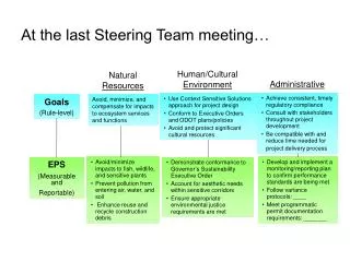
At Our Last Meeting • Need for ASBS monitoring • Southern Cal has same issues • Desire for “natural water quality” • Focus on receiving water • Primary concern was wet weather • Pilot Study, emphasis on reference sites this winter • Regional Study, reference and discharge, 2008-09
Monitoring Questions • What is the range of natural conditions at reference locations? • How does this range of natural water quality compare to ASBS discharge sites ? • What is the extent of impact at shorelines in ASBS with and without discharges?
Three Phase Approach • Develop natural water quality “limits” • Compare specific ASBS discharge locations to natural water quality limits • Estimate extent of ASBS shoreline that exceeds natural water quality limits
Southern California • ASBS monitoring moving forward as part of Bight 08 • Constituents and sampling design • Reference criteria determined at 90% open space, island and mainland sites • Rocky intertidal biological monitoring • Leveraging • Rocky subtidal collaboration • Bioaccumulation via NOAA/SWRCB/SCCWRP Mussel Watch
Natural Water Quality Committee • Discussed definition of natural water quality • Monitoring approach discussed • Committee supported overall approach • Recommended adding pesticides and nutrients to constituents list • Supportive of collaboration with MARINe for rocky intertidal
Salinity TSS Organic Carbon Metals PAHs Bacteria Pesticides Dioxin Toxicity Nutrients N, S N, S N, S N, S N, S N only ? S only S only ? Constituents NWQ Com advises NWQ Com advises
Reference Site Criteria • Open beach with breaking waves • No 303(d) listings • Minimal human disturbance • So Cal 90% Open Space • Cen/Nor Cal 95% or better Open Space? • Catchment size within the range of ASBS discharges • If possible, range of geologic conditions, watershed and shoreline • Cen/Nor Cal – watershed vegetation considered, but may be a function of latitude
GIS Information Used For Site Selection • ASBS layer (SWRCB) • Coastline Layer (Coastal Commission) • 2006 303(d) list (SWRCB) • City boundaries • Coastal Change Analysis Program 2000 land cover data set (NOAA CCAP) • Calwater hydrologic sub-areas • MARINe Intertidal sites • Ocean Discharge Points (SWRCB)