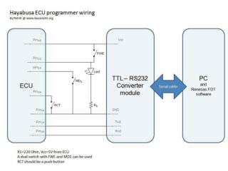
Hayabusa Data Archives
Hayabusa Data Archives. COSPAR Capacity Building Workshop on Planetary Science July 23 - Aug. 3, 2007 Montevideo, Uruguay. Makoto Yoshikawa (JAXA). Overview. Hayabusa science data has been released in April 2007 through a data distribution server placed at ISAS/JAXA.

Hayabusa Data Archives
E N D
Presentation Transcript
Hayabusa Data Archives COSPAR Capacity Building Workshop on Planetary Science July 23 - Aug. 3, 2007 Montevideo, Uruguay Makoto Yoshikawa (JAXA)
Overview • Hayabusa science data has been released in April 2007 through a data distribution server placed at ISAS/JAXA. • URL: http://hayabusa.sci.isas.jaxa.jp/ • The data type is fits or text. (total:2GB) • The data will be transformed into PDS format by the collaboration with Hayabusa science team members of US. • The data format is also discussed under the work of International Planetary Data Alliance (IPDA).
Data • AMICA : Images of Itokawa • NIRS : Infrared Spectrum • LIDAR : Distance between the spacecraft and Itokawa • XRS : X-ray Fluorescence Spectrum • SPICE : Ancillary data • Shape Model : Digital data of the shape of Itokawa
Remote Sensing Instruments onboard Hayabusa • Multi-Spectral Telescopic Imager (AMICA) > CCD viewing angle 5.7°with 8 band-pass filters > About 1500 still images obtained • Laser Altimeter (LIDAR) > Measurement accuracy of 1 m at 50m altitude > 1,670,000 hits obtained • Near-Infrared Spectrometer (NIRS) > 64-channel InGaAs detector at wavelengths of 0.8~2.1 micron > Viewing angle 0.1° (6-90 m per pixel spatial resolution) > More than 80,000 spectra obtained • X-ray Fluorescence Spectrometer (XRS) > CCD viewing angle: 3.5°, 160 eV resolution at 5.9 keV > 6,000 spectra from the asteroid surface obtained
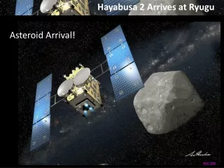
Cruising Phase 86,000km 4,000km Approach Phase Gate Position 20km Proximity Phase Home Position 10km Descent & Touch down 3km Itokawa Mission Sequence Launch 9 May 2003 Earth Swingby 19 May 2004 Asteroid Arrival 12 Sept. 2005 (Observations, sampling) Earth Return June 2010
Definition of the data level Level-0: raw data (telemetry data) Level-1: data preserved after format change of telemetry data (only telemetry data necessary for each instrument is included.) Level-2: data produced by processing the Level-1 data
Current Situation • Calibration for data archives are still ongoing, and necessary information for data analysis is being arranged from now on. • We do not have special tool to analyze our data. (You can use general tools such as IRAF, IDL, SPICE, etc, or you must make your own program.) • We do not have a tutorial set of data analysis yet.
What can we do in this Workshop? • The data of AMICA (NIRS and XRS data may not be appropriate for this time.) Ex 1. To study of the surface properties: the size distribution of boulders or craters Ex 2. To create color image by using images taken by different filters Ex 2. To study local topography by LIDAR • The shape model Ex. to create the light curve of Itokawa • SPICE data
Shape model Shape model of Itokawa is provided.
Lightcurve of Itokawa Kaasalainen et al, A&A 405, L29-L32 (2003)
Lightcurve of Itokawa by Hayabusa
Rough Terrain near Tsukuba J M Local Topography Measured by LIDAR Example: • Tsukuba Boulder with 3-4 m height was identified • A possible rock fissure was also identified • Rough Terrain: Surface roughness near Tsukuba Boulder: 2.2 m • Smooth Terrain: Surface roughness in the Muses Sea: 0.6 m (S. Abe, et al.,Science, (2006))