
近年の農耕地減少・耕作放棄地拡大による 温暖化への寄与 農業環境 技術研究所 吉田 龍平
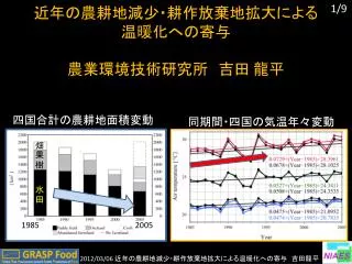
近年の農耕地減少・耕作放棄地拡大による 温暖化への寄与 農業環境 技術研究所 吉田 龍平. 四国 合計の農耕地面積変動. 同期間・四国の気温年々変動. 畑. 果樹. 水田. 1985. 2005. H23 年度は、耕作放棄地拡大→温暖化寄与. AMeDAS 観測の気温上昇量 最 高気温は 1.4 ℃ /21 年 上昇. 温室効果ガス. 耕作放棄地、水田減少等による効果は何℃か? ( 次スライドで手法と結果 ). H23 年度は、耕作放棄地拡大→温暖化寄与 . 水田. ③各地表面別の 地表面パラメータ. ②農耕地面積の減少. ①気温に対する

近年の農耕地減少・耕作放棄地拡大による 温暖化への寄与 農業環境 技術研究所 吉田 龍平
E N D
Presentation Transcript
近年の農耕地減少・耕作放棄地拡大による 温暖化への寄与 農業環境技術研究所 吉田 龍平 四国合計の農耕地面積変動 同期間・四国の気温年々変動 畑 果樹 水田 1985 2005
H23年度は、耕作放棄地拡大→温暖化寄与 AMeDAS観測の気温上昇量 最高気温は1.4℃/21年 上昇 温室効果ガス 耕作放棄地、水田減少等による効果は何℃か? (次スライドで手法と結果)
H23年度は、耕作放棄地拡大→温暖化寄与 水田 ③各地表面別の 地表面パラメータ ②農耕地面積の減少 ①気温に対する 地表面パラメータ感度 最高 +0.65℃
H23年度は、耕作放棄地拡大→温暖化寄与 水田 建物用地 図: 各土地利用面積変化由来の 気温変化 図: 農耕地アメダスの長期トレンド(最高、平均、最低) 表: 陸面由来の気温変化量と AMeDASの長期トレンド Yoshida et al. (in preparation to Earth Interactions)
H23年度成果 (RECCA関連 + 自身が1stのもののみ、白色 = 確定、黄色 = 準備中) [論文] 1. Yoshida R., T. Iizumi, and M. Nishimori (2012): Inter-model differences in the relationships between downward shortwave radiation and air temperatures derived from dynamical and statisitical downscaling models. J. Meteor. Soc. Japan. (in press) 2. 吉田 龍平、沢田雅洋、山崎剛、岩崎俊樹 (2011): 放射量連続観測とAMeDASを利用した宮城・山形・福島県北部における非静力学モデル放射量の評価. 天気、58、25-31. 3. Yoshida R., M. Nishimori, T. Iizumi, and T. Osawa: Contributions of increased agricultural abandonment area to recent surface warming trend in Shikoku Island, Japan. (in preparation to Earth Interactions) [学会発表 海外] 1. Yoshida, R., T. Iizumi, M. Nishimori:Intercomparison of downward shortwave radiaiton and surface air temperatures derived from dynamical and statistical downscaling models. American Geophysical Union Fall Meeting 2011. San Fransisco (December 2011) 2. Yoshida. R., M. Nishimori, T. Iizumi, and T. Osawa: Contributions of increased agricultural abandonment area to recent surface warming trend in Shikoku Island, Japan. European Geosciences Union General Assembly 2012, Vienna (April 2012, in preparation)
H24年度は、 土地利用変化込の高知シナリオを作成します スペック: dx=5km, dt=2hr, 1991-2000 (3 models), 2051-2060 (2), 2091-2100 (3) NHRCM, NRAMS, TWRF MIROC5, MRI-3 NHRCM, NRAMS, TWRF 図: シナリオ作成概念図
H24年度は、 土地利用変化込の高知シナリオを作成します MIROC5 MRI-3 (100-150km) JMA-NHM (気温のみ) 陸面由来追加 dx=5km dt=2hr 3 period 高知(四国) シナリオ Binary format 20km 5km Period 2 (2051-2060) NHRCM NRAMS TWRF (20km) 5km ※計算機資源の余裕も見つつ、可能であれば高知市を中心とした1kmメッシュのシナリオも作成します。 Period 1 (1991-2000) Period 3 (2091-2100)
S8-RECCA共通シナリオ(花崎ほか 2012)による 土地利用由来の気温変化シナリオの例 (速報) ・人口を説明変数として2006年の土地利用面積を上下させている (都市減少 → その他用地(空き地)、荒地増加) 2100 – 2006 の変化量 (a)夏季日平均気温 、(b)最高気温 [℃] (d)建物用地面積 (e)空き地 (f)荒地 [km2] 都市減少分 → 空き地と荒地に等配分
宣伝 ・RECCA-Kochi 公式HPの作成(中) http://wind.gp.tohoku.ac.jp/~ryu/recca_kochi/recca_kochi.html で試験公開中(3月中に農水省サーバーへ移転) ユーザー名: kochiパスワード: 現高知県知事の氏名 こんなかんじです
H23年度は、耕作放棄地拡大の温暖化への寄与を明らかにしましたH23年度は、耕作放棄地拡大の温暖化への寄与を明らかにしました L: 水田、果樹園、畑、耕作放棄地、建物用地 Ta: 日最高、平均、最低気温 ∂Ta/∂pi : JMA-NHMから算出 (時間の都合上、詳細は省略) Δpi: 面積変化に伴う地表面パラメータ変化量 (面積変化量は農林業センサスから)