Download
1 / 20
200 likes | 358 Vues
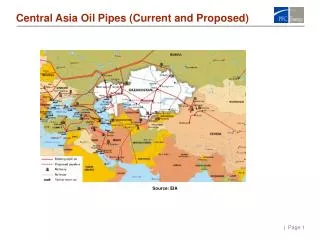
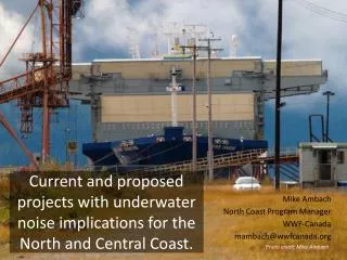
Current and proposed projects with underwater noise implications for the North and Central Coast. Mike Ambach North Coast Program Manager WWF-Canada mambach@wwfcanada.org. Photo credit: Mike Ambach. Stewart. BC’s North Coast. DIXON ENTRANCE. CHATHAM SOUND. HECATE STRAIT. DOULGAS CHANNEL.

E N D
Current and proposed projects with underwater noise implications for the North and Central Coast. Mike Ambach North Coast Program Manager WWF-Canada mambach@wwfcanada.org Photo credit: Mike Ambach
Stewart BC’s North Coast DIXON ENTRANCE CHATHAM SOUND HECATE STRAIT DOULGAS CHANNEL CAAMANOSOUND
Sources Thank you. • MCTS data • Prince Rupert LNG Project Description 2013 • Pacific Northwest LNG Project Description 2013 • LNG Canada Project Description 2013 • Transport Canada TERMPOL Assessment for Enbridge Northern Gateway 2012 • Shipping on the British Columbia Coast: Current Status, Projected Trends, Potential Casualties, and Our Ability to Respond: A Briefing Report 2011 • BC Shipping News • Prince Rupert Port Authority Annual Reports • PRPA: Shipping Trends and Future Activity on BC North Coast 2012 • Aleutian Islands Risk Assessment Study 2010 • Southeast Alaska Vessel Traffic Study 2012 • PNCIMA Atlas 2012 • BCMCA Marine Atlas of Pacific Canada 2012 • Port of Kitimat Economic Development Statistics, Major Projects briefs • Origin, Destination & Marine Traffic Volume Survey TERMPOL Surveys and Studies 2010 • District of Kitimat Investment Summary 2013-2015 • Kitimat Modernization Project • Stewart Bulk Terminals Expansion Project • Northwest BC Major Projects, Terrace Economic Development Association 2011 • Adding it All Up Conference Proceedings, 2012 Bulkley Valley Research Institute • Canada LNG Project Description • PRPA Land Use Plan 2020 • Transportation Assessment of the Central and North Coast of British Columbia March 2, 2009
_by region 2006 2013 2018 2024 * Approximations based on multiple data sources
_by vessel class 2006 2013 2018 2024 * Approximations based on multiple data sources
_ by existing and proposed 2006 2013 2018 2024 * Approximations based on multiple data sources
_ existing and proposed 2006 2013 2018 2024 * Approximations based on multiple data sources
Vessel Categories 2012 Prince Rupert Zone Movement, total sector transits (from MCTS data)
A few caveats… • Does not represent seasonal variation • Does not represent ship presence • Does not reflect variability in ship size • Does not capture tug-related service for construction phases, or operation presence • Resource extraction projects have lifespans Photo credit: Mike Ambach
Non-shipping • Ocean Renewables • Seismic • Construction • Small Vessels Photo credit: Mike Ambach
Typical Timeline: When and how does sound get identified? Source: Pacific Northwest LNG Project Description
Gold Rush Mitigation • Baseline? • Seasonal variation? • Geographic range of acoustic impacts? • Masking effect? • Cumulative effects, including “reasonably foreseeable future projects” A common, shared understanding of realistic future scenarios.
Source: Aleutian Islands Risk Assessment, Phase A – Preliminary Risk AssessmentDet Norske Veritas (2010)
Source: Aleutian Islands Risk Assessment, Phase A – Preliminary Risk AssessmentDet Norske Veritas (2010)
Source: Aleutian Islands Risk Assessment, Phase A – Preliminary Risk AssessmentDet Norske Veritas (2010)
Discussion How to plan around (noise) mitigation in a rapidly changing environment? What is essential to know about proposed/new vessel traffic now, and how can that flow of information be facilitated?