Download
1 / 1
10 likes | 204 Vues
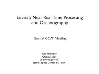
INPUT DATA. TO INITIALISE THE PARAMETERS. TO COMPUTE THE WAVEFORM OFF NADIR ANGLE. TO COMPUTE LONG PERIOD EQUILIBRIUM TIDE HEIGHTS. TO COMPUTE AVERAGED ALTITUDE RATE AND DOPPLER EFFECTS. TO COMPUTE THE TOTAL OCEAN TIDE. TO COMPUTE THE PHYSICAL PARAMETERS.

E N D
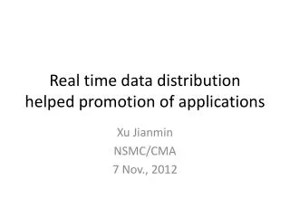
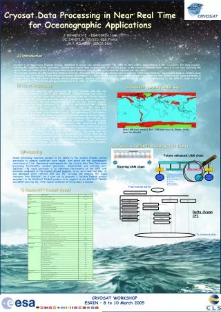
INPUT DATA TO INITIALISE THE PARAMETERS TO COMPUTE THE WAVEFORM OFF NADIR ANGLE TO COMPUTE LONG PERIOD EQUILIBRIUM TIDE HEIGHTS TO COMPUTE AVERAGED ALTITUDE RATE AND DOPPLER EFFECTS TO COMPUTE THE TOTAL OCEAN TIDE TO COMPUTE THE PHYSICAL PARAMETERS TO COMPUTE THE MEAN SEA SURFACE HEIGHT TO AVERAGE THE ELEMENTARY ESTIMATES TO COMPUTE THE GEOID HEIGHT TO COMPUTE THE SEA STATE BIAS TO COMPUTE THE OCEAN DEPTH / LAND ELEVATION TO COMPUTE THE 10 METERS ALTIMETER WIND SPEED TO COMPUTE THE U AND V COMPONENTS OF THE MODEL WIND TO COMPUTE THE SEA ICE FLAG OUTPUT DATA Cryosat Data Processing in Near Real Time for Oceanographic Applications J. BENVENISTE - ESA/ESRIN, Italy OZ. ZANIFE, B. SOUSSI - CLS, France M. P. MILAGRO – SERCO, Italy 1) Introduction CryoSat is an Opportunity Explorer mission, dedicated to answer one science question. The focus of that science exploration is in the cryosphere. For many reasons, including for simplicity of the operations, CryoSat may acquire data systematically all over the planet in the classical altimeter mode, when it is not busy exploiting the special SAR and SARin modes. This means that classical altimeter data (in LRM mode) would be acquired over the ocean. The current CryoSat L2 LRM (Low Rate Mode) processing chain does not address specialised ocean processing, other than elevation, sigma C and sigma 0. Indeed ocean processing was not included in the original processing requirements. A review of the available processing documentation confirms that no specialised ocean processing is present other than the above retracker derived parameters. Specific additional processing steps needed to add ocean processing to the LRM L2 chain is to be encapsulated in a CFI software package developed by CLS, under an ESRIN contract. 2) Users Requirement 2) CryoSat operating modes map Well aware of the important user requirement for radar altimeter data over the ocean, today supplied by ERS-2, GFO, ENVISAT, TOPEX/Poseidon and Jason-1, ESA set out to see how ocean data could be exploited from the CryoSat mission and to develop the necessary processing chain to provide ocean data to users from the CryoSat archive. The user requirements are also for fast delivery CryoSat LRM data over the ocean, which are the same as for the ENVISAT RA-2 FDMAR and IMAR products (3 hours and 3 days latency, resp.). The main user requirement for fast delivery altimeter data is “Improved sampling in space and time” (Cotton et al 2004, in the GAMBLE report). The applications of fast delivery CryoSat LRM data over the ocean are twofold: sea state and sea surface height. The users of such a CryoSat FDMAR product are worldwide Met Offices, the Navies, Groups supporting offshore and coastal activities, Ocean circulation modelers using altimetry data through assimilation (the international GODAE Project). The required latency for assimilation in meteorological models and ocean battlefield models is 3 hours. The required latency for assimilation in the GODAE models is on the availability of the MOE orbit (2-3 days). This means that the more data that can be delivered in 3 hours the better. The 3 hour data and its complement disseminated several hours later will be used for offshore applications and assimilation in ocean models for ocean circulation forecasting using enhanced meteo fields and orbit solution. Today GODAE users are served by DUACS (CNES), including enhanced data from all flying radar altimeters. Blue: LRM (over oceans), Red: SAR (over sea-ice), Green: SARin (over ice-sheets) 4) CryoSat ocean NRT processing chain scheme 3) Processing Future enhanced LRM chain Ocean processing functions needed to be added to the original CryoSat ground processing to compute significant wave height, wind speed and the oceanographic corrections at 1 Hz. Operational requirements for the CryoSat Near Real Time ocean processing functionality, product generation, dissemination and archiving were specified. The ocean processor is an additional functionality of the IPF2 LRM processor component of the CryoSat Ground Segment, to be run in near real time. It was developed under contract with CLS (F), re-using and adapting the ocean retracker from ENVISAT RA-2 with aim to generate a CryoSat FDMAR product equivalent to the ENVISAT FDMAR product to be supplied to the ENVISAT FDMAR and IMAR users by ftp. After launch validation of the product is planned Existing LRM chain • (- Surface discriminator • Range and Corrections • Retracking • Slope correction • Elevation • Slope Doppler • MSS and Geoid) From internal buffer 4) Ocean NRT Product format Delta Ocean CFI To internal buffer