Enhanced Radar Data Acquisition for Volcanology Research in Indonesia
The EarthWatch and Intermap collaboration provided essential radar data to support volcanology research in Indonesia, particularly in East Java. This data was integral for evaluations tied to NASA's SRTM and VCL missions, offering unique high-resolution topographic information. The Scientific Data Purchase Project facilitated access to this data, aiding the scientific community while negotiating special data rights for Department of Defense use. Despite some issues regarding data quality and delivery timelines, the feedback indicates high value for ongoing volcanological studies.

Enhanced Radar Data Acquisition for Volcanology Research in Indonesia
E N D
Presentation Transcript
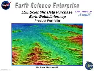
ESE Scientific Data Purchase EarthWatch/Intermap Product Portfolio Rio Aquan, Honduras CA 02/02/2000 Rev. 2.0
EarthWatch Sites JAVA, Indonesia 13 10 11 14 12
EarthWatch Sites Central America 1 2 9 3 5 4 6 7 8
168 306 314 281 299 307 275 296 165 280 208 285 308 EarthWatch CONUS Sites 55 274 228 44
Task Information EarthWatch Indonesia Data Collection The EarthWatch/ Intermap radar acquisition over areas in Indonesia was requested by the Scientific Data Purchase Project Tasking and Measurements Committee to support volcanology research being conducted by the ESE Natural Hazards and Solid Earth Program. As NIMA was very interested in this data set, special data rights were negotiated with EarthWatch to allow use of the data by the Department of Defense for unspecified applications.
To all NASA Earth Science Enterprise Scientific Data Purchase data recipients: NASA's Commercial Remote Sensing Program at Stennis Space Center, Mississippi, is dedicated to enhancing and improving current and future Earth Science Enterprise Science Data Purchase activity. In an effort to assure the Data Purchase project is meeting the needs and expectations of the data recipients in the scientific community, we would appreciate if you could take the time to answer the following questions: Data Recipient's Name PETER MOUGINIS-MARK SDP Task or Order No. 330 Date data shipped 8/13/99 Date of Response 1/11/2000 (1) Please rate from 1 (data seriously flawed) to 10 (data exceptional) your impression of the quality of the data received. Rating _____8_____ Comment: There are a few seams in the digital elevation data set, and some larger gaps (due to extreme topography) in the backscatter image. But in general both data sets are very good. (2) Please rate from 1 (data not useful) to 10 (data highly useful) your impression of the the usefulness of the data in your research/ application. Rating _____8_____ Comment: These data will be used as part of a validation effort in support of NASA's SRTM and VCL missions. Thus it's not easy to say at this time how useful the data really will be. However, it's hard to get NASA's DC-8 aircraft out to this part of the world, so that these are currently unique data for the analysis of the volcanoes. In this regard, the data are very helpful just because they provide the only high resolution images and by far the best topographic information. (3) Please rate from 1 (service non-responsive) to 10 (service exceptional) your experience with the Scientific Data Purchase process from data request through data delivery. Rating ____7______ Comment: There were times when I wasn't sure where my data were, but I understand that there were paperwork issues regarding the release of these high resolution data for areas outside the U.S. It would have helped to know that there was a problem. Also, there were a few minor points of confusion about area of coverage available, but by and large it was good service. (4) Please rate from 1 (service non-responsive) to 10 (service exceptional) your experience with the Scientific Data Purchase Data vendors (Earth Watch, Intermap, Positive Systems, EarthSat) as applicable. Rating _____7_____ Comment: I have only interacted with Intermap. They obviously want to sell more data, and have additional flights to exotic places, and so their priorities do not exactly match the research schedule that I have. Asking them about the radar system (such as how exactly they mosaic the topographic data from different swaths) is also a difficult issue since this is a commercial secret that doesn't help understand data quality.
(5) Please let us know if there have been any publications as a result of research using the data. OK. But it's way too early yet. (6) In order for us to better report to our sponsors, please describe any benefits to the U.S. tax payers derived from your use of the data. We will use these data to validate instruments flown in space by NASA. Ultimately, gaining an understanding of the data quality we will be able to make recommendations about the use of Star-3i data for mapping in hazardous areas (such as flood plains). (7) A. Do you encourage continuation of the current Scientific Data Purchase effort into the future? Well, it depends what the ultimate source of the money is. If the funds are earmarked from NASA's Code Y budget, this doesn't help the science community since there are considerable overheads and different priorities. If the program is a true add-on to the budget, then additional data will be helpful. B. Do you encourage the Scientific Data Purchase Project to pursue new sources of commercial data, and if so, what data products? Yes. It would be particularly helpful to be able to buy large volumes of ERS tandem data for interferometric radar studies. If ERS-1 cannot be operated this amount of time, purchasing ERS-2 data with a 35-day repeat would still enable many interesting studies to be conducted around the world. A second data product is the purchase of RADARSAT images outside the ASF and McMurdo station masks. Fine beam data for various parts of the world would be very helpful for mapping and change detection studies. (8) Please provide any other general thoughts or suggestions as to how we can improve the project. The type of meeting planned at Stennis in mid-February is really helpful, since it will (I hope) bring together the scientists and the commercial operators. I am currently having the same type of discussion with Space Imaging regarding the operation of the IKONOS spacecraft. Science experiments are different from routine operations, so that it would be good for both sides to hear each other's goals and the limitations of the system. Thank you for taking the time to complete the above questionnaire. Feel free to contact me anytime at (228) 688-7708 if you have any questions or comments regarding the NASA ESE Scientific Data Purchase project. Sincerely, Fritz Policelli Scientific Data Purchase Project Manager Commercial Remote Sensing Program Office NASA, Stennis Space Center
Task Information EarthWatch Central America Data Collection The EarthWatch/ Intermap radar acquisition over areas in Central America was requested by the Scientific Data Purchase Project Tasking and Measurements Committee to support environmental research being conducted by the ESE Land-Cover Land-Use Change and Natural Hazards and Solid Earth Programs. The project participants include researchers at NASA JPL, NASA MSFC, University of Maine, and the Central American Commission on the Environment and Development. The intent of the research is to support the development of a biological corridor in Central America.
Site # 1 Central America Belize
Central America Site # 2 Honduras
Central America Site # 3 Honduras
Central America Site # 4 Honduras
Central America Site # 5 El Salvador
Central America Site # 6 Nicaragua
Central America Site # 7 Costa Rica
Central America Site # 8 Panama
Central America Site # 9 Guatemala
To all NASA Earth Science Enterprise Scientific Data Purchase data recipients: NASA's Commercial Remote Sensing Program at Stennis Space Center, Mississippi, is dedicated to enhancing and improving current and future Earth Science Enterprise Science Data Purchase activity. In an effort to assure the Data Purchase project is meeting the needs and expectations of the data recipients in the scientific community, we would appreciate if you could take the time to answer the following questions: Data Recipient's Name DANIEL IRWIN SDP Task or Order No. 466A Date data shipped 11/30/99 Date of Response _____________ (1) Please rate from 1 (data seriously flawed) to 10 (data exceptional) your impression of the quality of the data received. Rating ___10_______ Comment: (2) Please rate from 1 (data not useful) to 10 (data highly useful) your impression of the the usefulness of the data in your research/ application. Rating __10________ Comment: (3) Please rate from 1 (service non-responsive) to 10 (service exceptional) your experience with the Scientific Data Purchase process from data request through data delivery. Rating __10_____ Comment: (4) Please rate from 1 (service non-responsive) to 10 (service exceptional) your experience with the Scientific Data Purchase Data vendors (Earth Watch, Intermap, Positive Systems, EarthSat) as applicable. Rating __10________ Comment: Everything has gone very well so far. I'm pleased to be a registered user of the Data Purchase site.
(5) Please let us know if there have been any publications as a result of research using the data. (6) In order for us to better report to our sponsors, please describe any benefits to the U.S. tax payers derived from your use of the data. (7) A. Do you encourage continuation of the current Scientific Data Purchase effort into the future? B. Do you encourage the Scientific Data Purchase Project to pursue new sources of commercial data, and if so, what data products? (8) Please provide any other general thoughts or suggestions as to how we can improve the project. Thank you for taking the time to complete the above questionnaire. Feel free to contact me anytime at (228) 688-7708 if you have any questions or comments regarding the NASA ESE Scientific Data Purchase project. Sincerely, Fritz Policelli Scientific Data Purchase Project Manager Commercial Remote Sensing Program Office NASA, Stennis Space Center
Task Information EarthWatch Virginia Beach Data Collection The EarthWatch/ Intermap radar acquisition over the Virginia Beach area was requested by the Scientific Data Purchase Project Tasking and Measurements Committee to support a flood plain mapping project being conducted by the ESE Natural Hazards and Solid Earth Program. The project participants include researchers from NASA JPL, FEMA, and the Army Corps of Engineers Topographic Engineering Center.
Task Information Tasking Request 308-2 - Mississippi Use of data to support research The Databuy Mississippi coast terrain data has a vertical resolution of 1-2 meter, and a horizontal resolution of 2.5 meters, and is therefore more accurate than current terrain data used in storm surge estimates. Furthermore, since the coast has experienced much development this decade, it is also more current. Since the terrain data is estimated by remote sensing technology, the horizontal depiction of the terrain is also more accurate. Current terrain estimates for storm surge planning is based on land surveys. Related research to this project is funded by NASA, titled "Boundary Layer Processes Affecting Tropical Cyclone Intensity Change," and "Meteorological and Programming Support" funded by NASA. Both projects are supporting tropical cyclone (hurricane) modeling efforts. The director of the hurricane program for the Mississippi Emergency Management Agency, has expressed a strong interest in this dataset as well.
Task Request # 308 Gulf Coast, Mississippi USA
To all NASA Earth Science Enterprise Scientific Data Purchase data recipients: NASA’s Commercial Remote Sensing Program at Stennis Space Center, Mississippi, is dedicated to enhancing and improving current and future Earth Science Enterprise Science Data Purchase activity. In an effort to assure the Data Purchase project is meeting the needs and expectations of the data recipients in the scientific community, we would appreciate if you could take the time to answer the following questions: Data Recipient’s Name PAUL CROFT SDP Task or Order No. 308 Date data shipped 8/13/99 Date of Response _____________ (1)Please rate from 1 (data seriously flawed) to 10 (data exceptional) your impression of the quality of the data received. Rating _____7____ Comment: (2)Please rate from 1 (data not useful) to 10 (data highly useful) your impression of the the usefulness of the data in your research/ application. Rating _____5_____ Comment: (3)Please rate from 1 (service non-responsive) to 10 (service exceptional) your experience with the Scientific Data Purchase process from data request through data delivery. Rating _____8_____ Comment: (4)Please rate from 1 (service non-responsive) to 10 (service exceptional) your experience with the Scientific Data Purchase Data vendors (Earth Watch, Intermap, Positive Systems, EarthSat) as applicable. Rating ____N/A______ Comment:
(5)Please let us know if there have been any publications as a result of research using the data. Not yet! • (6)In order for us to better report to our sponsors, please describe any benefits to the U.S. tax payers derived from your use of the data. • (7) A. Do you encourage continuation of the current Scientific Data Purchase effort into the future? Yes • B. Do you encourage the Scientific Data Purchase Project to pursue new sources of commercial data, and if so, what data products? Yes • (8)Please provide any other general thoughts or suggestions as to how we can improve the project. • Thank you for taking the time to complete the above questionnaire. Feel free to contact me anytime at (228) 688-7708 if you have any questions or comments regarding the NASA ESE Scientific Data Purchase project. • Sincerely, • Fritz Policelli • Scientific Data Purchase Project Manager • Commercial Remote Sensing Program Office • NASA, Stennis Space Center
Task Information Tasking Request 208-3 - New Mexico The data will be used to : 1) utilize terrain model and radar imagery in developing a second generation, high resolution vegetation map for the Sevilleta NWR, 2) utilize terrain model in developing an accurate, high resolution soils map for the Sevilleta NWR, 3) utilize terrain model and radar imagery for hydrologic, energy/water-balance, and plant production modeling efforts, 4) utilitarian purposes of terrain model, especially for image orthorectification; 2d and 3d visualizations of terrain and vegetation (utilizing other available imagery) over the Sevilleta NWR and particularly at focal research sites; high resolution phyiographic characterizations over the entire Sevilleta NWR; stream channel and basin generation, etc.
Task Request # 208 White Sands, New Mexico USA
Task Information Tasking Request 228-1 - Louisiana Use of data to support research There is a problem in Coastal River Flood Forecasting in a residential river basin. High quality river forecast models exist as well as a network of river stage-sea level real-time observations, however, a quality DEM for use in modeling is unavailable. The objective is to create and integrate a DEM for lower Amite River Basin into regional forecast activities of USGS and NOAA river forecast warning center. Flooding in this basin is driven by local and regional meteorology as well as fluctuations in sea/lake level. The extremely high quality imagery and the DEM of the Star 3i system will be field checked, edited where necessary and integrated into the regional river flood model.
Task Request # 228 Amite Basin, Louisiana USA
Task Information Tasking Request 274-1 - Arizona Use of data to support research The primary research area, the USDA-ARS Walnut Gulch Experimental Watershed (Tombstone, Arizona) is encompassed by the requested region. Walnut Gulch is a highly-instrumented watershed with a rich geographic information system (GIS) database that serves as an excellent location for investigation into rainfall- runoff and geomorphic processes. Because the processes under investigation are spatially distributed and not readily measured in the field, remotely sensed data is integral to our research. A Star3i scene (2.5m image and 10m DEM) was acquired from last year's (1998) summer season, and the research team is eager to acquire another set of these data. A second set of data would allow further research into detailed spatially distributed land surface change detection. The time-integrated movement of sediment throughout a basin is heretofore a poorly-understood process due to limited sampling techniques. The Star3i X-band IFSAR DEM product is of significantly higher quality than currently available data sets over much of the requested region. A GIS database was constructed with conventional 30m DEM data over the entire region, as well as a series of high-resolution DEMs (ranging from 10m to 40m) within the Walnut Gulch watershed. The IFSAR data will serve as a basis for interpreting DEM-based error in hydrologic assessment and modeling. Historically, landscape processes and model development have linked watershed processes to a single validation point (the watershed outlet). While a useful construct, the investigation and interpretation of spatially-distributed watershed processes using models calibrated and validated on a single point is inherently limiting; internal compensating errors may inadvertently yield strong results even if the internal functions are incorrect. Recent research has shown the benefits of using photogrammetry for internal validation of process models at small scales, and SAR data offers the potential for accurate internal investigation and validation at a range of scales up to and including the basin scale.
Task Request # 274 Walnut Gulch, Arizona USA
Task Information Tasking Request 280-2 - California Use of data to support research The data will be used in a variety of ways. First, maps of canopy topography at fine resolution will be compared with airborne LIDAR observations. The project team is currently planning a VCL airborne simulator flight (the LVIS instrument) over these areas this summer. By aggregating the IFSARE measurements, pseudo-waveforms can be created that recreate the full return, coarse footprint (25 m) of the airborne LIDAR system and VCL. These activities will enable calibration of algorithms (for creating transfer functions) that derive canopy top heights, to validate LIDAR observations, and to validate the retrieval of the vertical distribution of canopy materials. Bare earth IFSARE measurements will be used to validate LIDAR retrievals of topography in rugged terrain. The project team will intercompare IFSARE and LIDAR estimates of canopy topography and structure with ground measurements from numerous USFS permanent plots, as well as those of other NASA investigators at Sierra National Forest, Seqouia National Forest and Sequoia National Park. In addition, the project team is working with the USFS for using remote sensing for mapping of forest structure (e.g. LAI, vertical foliage diversity, old growth measures, etc). The IFASRE data collected will be extremely valuable for developing and assessing multi-sensor fusion techniques. Lastly, the area is a VCL Core Validation Site. The data will be used to validate VCL on-orbit retrievals. Because the requested area is so large, there will be a great number of coincident VCL observations that will occur. In addition, the team will underfly VCL with the airborne LIDAR system in this area and use the requested data to provide a link between ground measurements, coarse airborne LIDAR measurements, and VCL LIDAR observations.
Task Request # 280 Fresno, California USA
Task Information Tasking Request 285-1 - Arizona Use of data to support research The study will be conducted over a large agricultural region south of Phoenix Arizona characterized by large fields of primarily cotton, alfalfa and sorghum. The project team has already ordered images from the recently launched Landsat7 ETM+ sensor for the dates of 7 and 23 August, and 8 and 24 September 1999. These are the dates of maximum cotton and sorghum maturity and maximum alfalfa vigor. The project team hope to obtain a Star3i X-band image covering the same area on one of these dates. It would be best to be able to work with the commercial provider to obtain the imagery on a date when clear-sky optical imagery could be obtained. On the date of the overpasses, we will make a drive-by survey of crop conditions over a wide area. This will allow us to validate the findings of our optical/SAR analysis. After the images are obtained, an immediate survey of the scenes will be performed for obvious fields of interest to this study, along with another survey of those fields to record post-overpass field conditions. These surveys will be used to validate the results obtained through optical/SAR coincident image processing. The investigation of the usefulness of Star3i X-band data for agricultural applications is the main focus of this research. There is a chance (not yet confirmed) that Radarsat C-band SAR imagery can be obtained on 13 and 20 August, and 6 and 30 September. This would enhance the analysis by allowing comparison of the C- and X-band sensitivities to crop and soil conditions.
Task Request # 285 Tempe, Arizona USA
Task Information Tasking Request 296-2 - Washington, DC Use of data to support research The Earthwatch/Intermap IFSARE (Star3I) elevation mosaics will be used to improve runoff routing, to examine spatial variability in agricultural fields related to crop yield and hydrologic and nutrient flow modeling, as well as for studies of surface and canopy topography as they relate to species (e.g., bird) diversity patterns, and to canopy light interception (used to drive a net primary production model). There are extensive surface measurements in the requested coverage area to assist with image data calibration, validation, and for development of land surface variable recovery algorithms. These sites include the Beltsville Agricultural Research Center, the Smithsonian Environmental Research Center (Rhode River catchment), Montgomery County Parks & Planning Commission extensive resource inventory sites, and the Patuxent Wildlife Center (incorporating a wide variety of research activities, e.g., sites where canopy LIDAR acquisitions and tree stem measurements have been coordinated). The requested coverage area also encompasses the Washington DC metropolitan area. Our IFSARE request is being coordinated with that of the University of Maryland Baltimore Campus (Foresman et al.), collaborators on the mid-Atlantic RESAC, which extends coverage to include the Baltimore Ecosystem Study (LTER) and the Baltimore metropolitan area. The Baltimore - Washington corridor has experienced rapid land use change in recent years and provides an excellent region to leverage ongoing research.
Task Request # 296 Washington DC, USA
Task Information Tasking Request 299-1 - Indiana Use of data to support research Existing remote sensing data, GIS layers and environmentally relevant data that may be useful for the management of the Wildcat Creek watershed have been inventoried and are being assembled. Stakeholders are being surveyed to determine what they perceive as the data products that are of most use to them. Needs that have been identified in which remotely sensed data will be helpful include: 1. Analysis of watershed characteristics (especially land use, soil and topography) in relation to water quality and land use planning 2. Minimizing environmental impacts of swine production (water quality as well as air quality through setbacks from swine production units) 3. Quantification of temporal and spectral relationships between remotely sensed data and yield maps for corn and soybeans 4. Quantification of the relationships between high-resolution satellite image data and changes in inventories of natural resources (soil erosion, crop residue remaining on the soil surface, wetland area, forest canopy, etc.) and boundaries of areas affected by floods (inundated, sand washouts, etc.) and other local events 5. Algorithms that utilize satellite image data to locate and define the geo-referenced boundaries of farm fields and environmentally sensitive areas such as grassed-waterways, streams, ponds and waterways. Stakeholders will be surveyed after products are provided to determine how well these meet their needs.
Task Request # 299 Indianapolis, Indiana USA
Task Information Tasking Request 307-2 - Maryland Use of data to support research The requested data will support the stated research objectives by providing a consistent baseline topographic layer to support hydrologic modeling, forest and vegetation structural analysis, and data fusion. Additionally, the visible output can be utilized in the context of a continued multi-scale, multi-resolution comparative analysis for the land use and land cover characterization along the gradient of urban environments. This data request is being made in cooperation with the RESAC project at the University of Maryland, College Park (NAG1399011) to provide seamless DEM coverage over a number of regional sites, for use by these collaborating researchers. The requirement for the leaf-on and leaf-off capture is to calibrate and test two hydrologic models and to determine the accuracy of forest patch analysis mapping from AVIRIS, Landsat, and MODIS sensor systems. The data will be used to validate existing hydrologic database elements for the Baltimore-Washington region (i.e., streams) in conjunction with the testing and evaluation of Rhessys' adaptation for urban areas. The DEM will provide an important modeling component, building on the existing regional database established by the Baltimore-Washington Collaboratory. Finally, the DEM can be used to research the capacities required to manage, store, analyze and manipulate large-volume spatial data sets.
Task Request # 307 Baltimore, Maryland USA
Task Information Tasking Request 275-1- Colorado Use of data to support research The LightSAR EOCAP is providing the research team an opportunity to explore the commercial potential of Land Use/Land Classification derived from radar for use in the telecommunications industry. Current research has focused on the exploration of deriving land classes from the longer wavelengths in the AirSAR data. In support of the team's LightSAR EOCAP research project, the X Band data can supply the research with information in two areas. First, it will allow correction for distortions in the AirSAR and RADARSAT data sets and secondly, it will allow evaluation and comparison of the information content of the shorter wavelength, higher detailed X Band data. The topographic data acquired in the X Band mode will allow correction for distortions caused by changes in the terrain in the AirSAR and RADARSAT data sets. This higher detailed data will allow the research team to correct for the possibility of these image anomalies found in the longer wavelength data sets. By evaluating the higher information content of the shorter wavelength of the X Band data, the team hopes to get a good comparison with the results of the AirSAR and RADARSAT studies. In doing so, the ultimate goal is to come up with the best methodology to map land use and thus signal attenuation.
Task Request # 275 Denver, Colorado USA
Task Information Tasking Request 306-2- Montana Use of data to support research The project team, consisting of Yellowstone Ecosystems Studies (Y.E.S.) and Montana State University (MSU) researchers, requested data through EarthWatch from Intermap's airborne Interferometric Synthetic Aperture Radar for Elevation (IFSARE) system. The requested data set will support both scientific and remote sensing commercialization objectives. This data set covering Yellowstone National Park and the upper Yellowstone and Snake watershed areas outside of the Park will not only serve the purposes of the proposed project but should be in high demand by other Earth Science Enterprise researchers. The data will be useful for a wide range of applications involving land use, land cover, terrain modeling, and improved estimates of plant biomass. The Star-3i data set (both alone and in combination with hyperspectral data) will be used to help identify, assess, and validate potential ecological indicators in stream and riparian areas. The data requested will allow researchers to study effects of ecosystem disturbances on at least six different orders of stream for both the upper Yellowstone and Snake river watersheds. Research will center on analysis of stream morphology (including stream gradient, predicted flood areas, hydrogeomorphic units via water surface ruggedness, substrate particle size) and riparian vegetation (including community structure, above ground biomass, successional gradient, and other riparian/hydrogeomorphic relationships). All of these factors are highly influenced by natural and human-induced disturbances occurring throughout watersheds and provide insights into these disturbances as well as into stream, watershed, and ecosystem health. In addition to the above, we propose to investigate other applications including the use of multiple sensor data (hyperspectral, radar, TIR) that will aid in our ability to "undress a stream"—the estimation of channel morphologic dimensions as if the water were missing from the stream or river—by estimation of flow, surface ruggedness, pool depth, substrate particle size, etc. We believe these data (both direct and indirect measurements) in combination with known hydraulic properties will allow the development of such predictive models. This capability would have enormous applications, including modeling of fish habitat, sedimentation, flood predictions, and wetland designation and assessments. The project will integrate results from analysis of other remote sensing data sets (e.g., hyperspectral, thermal infrared, etc.) with which the project team is currently working. This project will be highly leveraged by the project team's past, current, and planned future research projects in the study area. In addition to the above-mentioned research purposes, the requested data will be made available to the general public through the Y.E.S. web site. The site will enable the public to access EarthWatch/Intermap's data, conduct simple image processing and GIS analysis with these data and associated cartographic data, and study key environmental issues facing Yellowstone National Park and the surrounding Yellowstone ecosystem. The anticipated popularity of this site is expected to assist NASA in promoting awareness and commercialization of remote sensing data.
Task Request # 306 Yellowstone National Park, Montana USA
Task Information Tasking Request 281-5- Rhode Island Use of data to support research This data will be used to determine if reasonable products can be created for broadcast during NBC newscasts in Providence, RI. This data should aid in generating realistic views of the area which the public should be able to understand. It is important to have realistic landscapes to orient viewers of exactly where news and weather are occurring. This ties into the project team's ESIP Cooperative Agreement (NCC5-314) through NASA HQ that will enable us to increase the awareness of ESE data. This will demonstrate that distribution to the public of Earth Science Enterprise Data and Information products can be done through commercial television stations operationally. This research is expected to show value-added information products can be derived from ESE initiatives.
Imagery to be included in next revision Providence, RI
Task Information Tasking Request 314-1- Minnesota Use of data to support research The University of Minnesota currently has two follow-on NASA-sponsored (ESIP-III and RESAC) projects with the general objectives of extending this capability to additional application areas and users. The ESIP project, referred to as TerraSIP, has particular interest in developing improved approaches for land cover classification and monitoring. Radar data and high resolution digital elevation models (DEM) along with optical remote sensing data such as from Landsat-7's ETM+ will enable development and evaluation of the benefits of combining radar and optical data, as well as the use of ancillary data, in this case topographic relief, in decision-rule based approaches to classification. The Cloquet Forestry Center is a near ideal study site because of its long history as a forestry research station, and more specifically because of the relatively unique availability of data from a "continuous forest inventory" of over 400 plots on which species, size class, density, aspect, stand age, percent slope, slope length, position, and site index have been recorded. On each main plot, 0.14 acres in size, the species, diameter at breast height (dbh), crown class, crown ratio, height, and location of each tree greater than 12.6 cm dbh have been recently measured and recorded. Additional measurements characterizing smaller/younger trees are made on a sub-plot of each main plot. These data have been used for development of forest growth and yield models, and provide a unique resource for a detailed analysis of the relation of the biophysical characteristics of forest stands and trees to high resolution radar imagery and DEMs. It should be noted that an elevation of a few minutes can make a major difference in the species, growth and productivity of forests in the Upper Great Lakes Region. In addition to the research at the Cloquet Forestry Center we will use the radar data and DEMs, together with Landsat ETM+ and other high resolution optical data, for land cover classification of the entire study area, with emphasis on the forest cover type classification problem. This is a particularly interesting area for a study site because of the diversity of cover types (cropland, forests, and wetlands). About 60% of the total study area is forested and includes a broad range of types: jack pine, red pine, white pine, balsam fir, black spruce, tamarack, oak-hickory, elm-ash-soft maple, maple-basswood, aspen, birch, and balsam poplar. The area includes three physiographic strata with varying landforms, soils, and vegetation. It includes several state forests and the Jay Cooke State Park managed by our research partner, the Minnesota Department of Natural Resources, which has forest cover type maps and attribute data in a GIS.