Download
1 / 27
270 likes | 292 Vues
Lunar Reconnaissance Orbiter: Instrument Suite and Objectives. Lunar Reconnaissance Orbiter: Instrument Suite and Objectives.

E N D
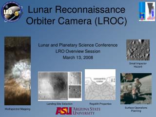
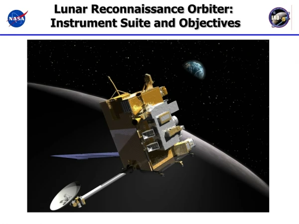
Lunar Reconnaissance Orbiter: Instrument Suite and Objectives
Lunar Reconnaissance Orbiter: Instrument Suite and Objectives Jan. 14 2004 – The President announced a new vision for space exploration that included among its goals “… to return to the moon by 2020, as the launching point for missions beyond … we will send a series of robotic missions to the lunar surface to research and prepare for future human exploration.”
Vision implies extended periods in space and on the Moon • Unknown terrain, poor maps • Radiation Environment • Long Cold Nights and Warm Days • Daytime 400 K (266 F) • Nighttime 100 K (-280 F) • Long Way From Home • Exploitable Resources? • - Water • - Shelter • Energy
LRO Objectives • Locate potential resources • Water at the lunar poles? • Continuous source of solar energy • Mineralogy • Space Environment • Energetic particles • Neutrons • Safe Landing Sites • High resolution imagery • Global geodetic grid • Topography • Rock abundances • New Technology • Advanced Radar
LRO Mission Overview • Launch on an Atlas V into a direct insertion trajectory to the moon. Co-manifested with LCROSS lunar impacter mission. • On-board propulsion system used to capture at the moon, insert into and maintain 50 km mean altitude circular polar orbit. • 1 year exploration mission followed by handover to NASA Science Mission Directorate. • Orbiter is 3-axis stabilized, nadir pointed, operates continuously during the primary mission. • Data products delivered to Planetary Data Systems (PDS) within 6 months of completion of primary mission. Polar Mapping Phase, 50 km Altitude Circular Orbit, At least 1 Year LRO LCROSS Commissioning Phase, 30 x 216 km Altitude Quasi-Frozen Orbit, Up to 60 Days 4.00 m 2.25 m Stack CG Height CEM Minimum Energy Lunar Transfer Lunar Orbit Insertion Sequence
LROC/NACs: Narrow-Angle Cameras • Targeted Imagery • Hazards • Topography • Day Side • Timeline Driven DLRE: Diviner Lunar Radiometer Exp. • - Temperature • Lighting • Hazards • Resources • Full Orbit • Autonomous CRaTER: Cosmic Ray Telescope… LAMP: Lyman-Alpha Mapping Project • - Radiation Spectra • Tissue Effects • Full Orbit • Autonomous • Water-Frost • PSR Maps • Night Side • Autonomous Instrument Overview LOLA: Lunar Orbiter Laser Altimeter LROC/WAC: Wide-Angle Camera • - Topography • Slopes • Roughness • Full Orbit • Autonomous • Global Imagery • Lighting • Resources • Day Side • Autonomous LR: Laser Ranging Mini-RF: Synthetic Aperture Radar • - Topography • Gravity • GSFC LOS • Autonomous • Tech Demonstration • Resources • Topography • Polar Regions • Timeline Driven LEND: Lunar Explr. Neutron Detector • - Neutron Albedo • Hydrogen Maps • Full Orbit • Autonomous
Topography Hazards Lighting Gravity Temperature Resources Radiation Neutrons Water-Frost Data Products David Everett--LRO Overview 7
LRO Emphasizes the Lunar Poles North Pole. 7 day orbital ground track prediction
LRO Emphasizes the Lunar Poles North Pole. 27 day orbital ground track prediction
Lunar Reconnaissance Orbiter Camera (LROC)Mark Robinson PI, ASU Wide and Narrow Angle Cameras (WAC, NAC) • WAC Design Parameters • Optics (2 lenses) f/5.1 vis., f/8.7 UV • Effective FL 6 mm • FOV 90º • MTF (Nyquist) > 0.5 • Electronics 4 circuit boards • Detector Kodak KAI-1001 • Pixel format 1024 x 1024 • Noise 30 e- • NAC Design Parameters • Optics f/3.59 Cassegrain (Ritchey-Chretien) • Effective FL 700 mm • FOV 2.86º (5.67º for both) • MTF (Nyquist) > 0.15 • Electronics • Detector Kodak KLI-5001G • Pixel format 1 x 5,000 • Noise 100 e- • A/D Converter AD9842A • FPGA Actel RT54SX32-S NAC WAC WAC Filters #1 - 315 #2 - 360 nm #3 - 415 nm #4 - 560 nm #5 - 600 nm #6 - 640 nm #7 - 680 nm
LROC Science/Measurement Summary • Landing site identification and certification, with unambiguous identification of meter-scale hazards. • Meter-scale mapping of polar regions with continuous illumination. • Unambiguous mapping of permanent shadows and sunlit regions including illumination movies of the poles. • Overlapping observations to enable derivation of meter-scale topography. • Global multispectral imaging to map ilmenite and other minerals. • Global morphology base map. LROC NAC camera will provide 25 x greater resolution than currently available 50 cm pixel dimension from 50 km Images geodetically tied to LOLA
Lunar Orbiter Laser Altimeter (LOLA)Dave Smith PI, GSFC Maria Zuber co-PI • LOLA measures: • RANGE to the lunar surface (pulse time-of-flight) ±10cm (flat surface) • REFLECTANCE of the lunar surface (Rx Energy/Tx Energy) ± 5% • SURFACE ROUGHNES (spreading of laser pulse) ± 30 cm • Laser pulse rate 28 Hz, 5 spots => ~ 4 billion measurements in 1 year. Beam Expander Receiver Telescope Radiator Detectors (2 of 5) Laser
25 m ~ 60 m ~25m 70 m LOLA will Derive an Accurate Global Lunar Reference System • LOLA will obtain an accuracy base of ~50 meters horizontal (point-to-point) and 0.5 to 1 meter radial • Current accuracy ~4 km • LOLA is a geodetic tool to derive a precise positioning of observed features with a framework (grid) for all LRO Measurements • Measure distance from LRO to the surface globally • Laser ranging from ground station to LRO provides precise orbit determination • Five laser spots along and across track • Measure distribution of elevation within laser footprint • Enhanced surface reflectance (possible water ice on surface) Crossovers occur about every 1 km in longitude and 3 deg in latitude at equator
Laser Ranging Overview • Transmit 532 nm laser pulses at 28 Hz to LRO • Time stamp Departure and Arrival times • Compute Range to LRO Greenbelt, MD LRO LR Timeshares LOLA Detector With Lunar surface returns Receiver telescope on HGAS couples LR signal to LOLA 1/28 sec Earth Win. (8ms) Lunar Win. (5ms) Data Xfer LOLA channel 1 Detects LR signal … LR Receiver Telescope Time Fiber Optic Bundle
Cabeus Shoemaker Shackleton Lunar Exploration Neutron Detector (LEND)Igor Mitrofanov PI, IKI South Pole • LEND is designed to measure lunar thermal, epithermal and energetic neutrons. • LEND improves spatial resolution for epithermal neutrons from 140km to 10km to locate areas of high hydrogen concentration • LEND footprint smaller than the Permanently Shadowed Regions of interest • Improves sensitivity of measurements in cold spots • Enables site selection LEND footprint White areas represent permanently shadowed regions as determined from ground based radar and overlaid on Lunar Prospector hydrogen concentrations
LEND Science Overview and Theory of Operations LEND collimated sensors CSETN1-4 and SHEN detect epithermal neutrons and high energy neutrons with high angular resolution to test water ice deposit on the surface epithermal neutrons high energy neutrons SHEN CSHEN 1 CSHEN 3
Lyman-Alpha Mapping Project (LAMP) Alan Stern PI, SwRI, Randy Gladstone (SwRI), Acting PI LAMP (with LTS): 5.3 kg, 4.6 W 0.2º×6.0º slit 520-1800 Å passband 20 Å point source spectral resolution
100% % Reflectance 30% LAMP Science/Measurement Summary • LAMP will be used to identify and localize exposed water frost in PSRs • LAMP will provide landform mapping (using Ly albedos) in and around the permanently shadowed regions (PSRs) of the lunar surface. • LAMP will demonstrate the feasibility of using starlight and UV sky-glow for future night time and PSR surface mission applications. • LAMP will Assay the Lunar Atmosphere and Its Variability
Diviner Lunar Radiometer (DLRE) David Paige PI, UCLA • Close copy of JPL’s Mars Climate Sounder (MCS) Instrument on MRO • 9-channel infrared radiometer 40K – 400K temperature range • 21 pixel continuous pushbroom mapping with ~300 m spatial resolution and 3.15 km swath width at 50 km altitude • Azimuth and elevation pointing for off-nadir observations and calibration Elevation Rotation Axis Telescopes Solar Cal Target Blackbody Cal Target Azimuth Rotation Axis
Diviner Investigation Goals • Characterize the moon’s surface thermal environment • Daytime • Nighttime • Polar • Map surface properties • Bulk thermal properties (from surface temperature variations) • Rock abundance and roughness (from fractional coverage of warm and cold material) • Silicate mineralogy (8 micron thermal emission feature) • Characterize polar cold traps • Map cold-trap locations • Determine cold-trap depths • Assess lunar water ice resources (using Diviner data in conjunction with topographic data and models) Clementine LWIR Daytime Thermal Image (200m /pixel) Lunar day, night and polar temperatures
Cosmic Ray Telescope for the Effects of Radiation (CRaTER)Harlan Spence PI, Boston University • CRaTER will measure the Linear Energy Transfer (LET) spectra behind tissue equivalent plastic (TEP) • LET spectra is the missing link connecting Galactic Cosmic Rays and Solar Energetic Particles to potential tissue damage • Characteristics • Nadir FOV: 75°, Zenith FOV: 35° • Avg. Orbital Power Allocation: 9.0 W • Mass Allocation: 6.36 kg • Daily Data Volume: 7.8 Gbits (Flare) • Data Collection: Full Orbit (113 minutes) • Inst. Daily Operations: Autonomous TEP Thin & Thick Pairs of Si Detectors CRaTER Telescope
Miniature Radio Frequency Demonstration Project (Mini-RF) Stewart Nozette PI, Mini-RF Lunar Demonstrations SAR Imaging (Monostatic and Bistatic) Chandrayaan-1 Lunar Reconnaissance Orbiter (LRO) Chandrayaan-1 LRO Coordinated, bistatic imaging in S-band, to be compatible with the Chandrayaan-1 and LRO spacecraft, can unambiguously resolve ice deposits on the Moon Other Coordinated Tech Demos: e.g ranging, rendezvous, gravity Monostatic imaging in S-band and X-band to validate ice deposits discoveries on the Moon X-Band Comm Demo Monostatic imaging in S-band to locate and resolve ice deposits on the Moon. Communications Demonstrations Component Qualification
LRO Instruments Work Together to Tell a Story Note from the LPI staff: Please double click the image to play the movie clip contained in this slide.
Current Status • All Instruments Mounted on the Spacecraft • All Major subsystems installed • Propulsion • Star trackers • Reaction wheels • C&DH • Ka & S band comm. • Optical Bench • Power electronics & battery • Solar Array • Environmental Testing is Completed • Mission Simulations and Rehearsals ongoing • Shipped to KSC Feb. 11 • Launch Window Opens June 17