2000
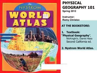
PHYSICAL GEOGRAPHY 101 Spring 2012 Instructor: Romy Christov. AT THE BOOKSTORE: Textbook: “ Physical Geography ”, McKnight’s, Darrel Hess Second California ed. 2. Nystrom World Atlas. 2000. U.S.A.

2000
E N D
Presentation Transcript
PHYSICAL GEOGRAPHY 101 Spring 2012 Instructor: Romy Christov • AT THE BOOKSTORE: • Textbook: • “Physical Geography”,McKnight’s, Darrel Hess • Second California ed. • 2. Nystrom World Atlas. 2000
U.S.A. 20% of Americans aged 18 to 24 could NOT find the United States on a map without labels!
Jay Leno asked how Mt. Rushmore was created. Over 60% said erosion.
What is geography? • Geo = ? • graphy=? • Where is something located? Why is it there? …. • Physical Geography encompasses the processes & features that make up Earth, including human activities where they interface with the physical environment. • It is closely related to many other sciences.
Population is like any other natural resource, it is not evenly distributed. Why are some regions empty and others very populated?
Human geography characteristics? What about physical geography impacts? Vancouver, BC
Geomorphology is the study of landforms. “Geo”= Earth “morphology”= shape Physical and human geography characteristics of Canyon lands National Park, Utah.
Technology, tools and methods • Maps, images, data, etc. • Today: digital, computer- assisted operations • Geographer is essential to the processes of analysis and problem solving • Complex computer- generated model of Earth, based on data gathered from satellites.
Spatial distribution-the extent of the area where featureexists • Spatial pattern-thearrangement of features in space- are they regular or random, clustered together or widely spaced? • This view of North America by night • *** distribution : • Where features are located or where they are absent? • *** pattern : • What is their arrangement?
English System Distance: inch, foot, yard, mile Volume: quart, gallon Weight: ounce, pound Temperature: F International system or” metric system” Centimeter (cm), meter (m), kilometer (km) Liter (g) Gram, kilogram (kg) Celsius (C) Numbers and Measurement Systemsbook page 5/6
The Environmental spheres p. 6/7 Air Hydrosphere Water The Earth system is a dynamic system (ever changing)- the seasons, ocean tides, earthquakes, volcanoes, floods. Biosphere Lithosphere Green stuff Land
Slumping is an example of an ever changing, dynamic earth. We will study slopes and mass movements
Tornadoes are in chapter 7 Global warming appears again in chapter 4 HUMAN- ENVIRONMENT INTERACTION: the effects of human activities on the environment, as well as the impacts of environmental processes on humans, have become topics of increasing concern.
Size and shape of Earth- page 9 • Our planet is a sphere- 200 B.C. Eratosthenes • Oblate spheroid • Diameter at the equator- 7927 mi, from pole to pole- 7900mi • The highest point- Mt. Everest in the Himalayas (29,035ft) • The lowest point- Mariana Trench of the Pacific ocean- 36,200ft deep) • Where it is located?
Great circles- page 11 • An imaginary circle through the center of Earth: • 1. It divides Earth into equal halves= hemispheres • 2. It is a circumference of Earth – 1 degree of latitude= 69 mi or 111km (40,000km/360 deg.=111km; 25,000mi/360 deg=69 mi) • 3. It marks the shortest routes between locations on Earth • (with a string) • 4. Circle of illumination What other circles (latitudes) are important?
p.11 Great Circle Great Circle small circle Only one latitude line= parallel is a Great Circle. Which one is it? The Equator All longitude lines= meridians are half Great Circles.
Book, page 12 N. Pole Prime Meridian Arctic Circle Tropic of Cancer Equator Tropic of Capricorn Which one is a low or high latitude? Which one is equatorial, Subtropical or Polar? Antarctic Circle S. Pole
35 The angular distance in degrees N/S of the equator • The angular distance E/W of the prime meridian atitude Ongitude
What are the coordinates of Mansfield? C-6 What community is found at F-3? Cleveland 35
LA has the same co-ordinates as Norco. How come? To the whole degree, LA and Norco are both 34ºN 118ºW.LA is 34º 03’N 118º 14’W. Norco is 33º 57’N 117º 33’W. LA is 34.05ºN 117.23ºW. Norco is 33.95ºN 117.55ºW. Therefore, LA and Norco have unique and separate positions. same
.M .P .C
90 N South Pole 90 S
£ 20 000 prize for a chronometer accurate to ½ a degree of longitude for a six week voyage John Harrison’s prize-winning time-keeper #4 won in 1765 D A V A S O B E L John Harrison- clockmaker
Cutty Sark Greenwich Royal Naval College Queen Anne’s House
Captain’s had two chronometers, one was LOCAL TIME the other GMT NEVER TOUCHED Changed every day WHEN?
p. 21 360 deg./ 24 hrs How many degrees of longitude does the Earth rotate in 24 hours? 24 x 15 = 360º How many time zones are there? 24
Time Zones p.22
HST AST PST MST CST EST AST Eastern Atlantic Book p. 22/23
Time Zones p. 22 1884 Washington Conference Norco & LA are in P.S.T. What time zone # are we? _________ If it is 13:05, July 4 in______ in LA, what time is it in: Time Zone # Time Day 1. Paris 2. Tokyo Rules Find: 1. Time zone numbers 2. Time difference If + + or - -} subtract them If + - } add the numbers 3. Direction If East- add the hours If West- subtract the hours PM Norco & LA 13:05 Paris Going E, Norco & LA 13:05 Tokyo Going E,
Time Zones 3 Norco & LA are in P.S.T., What time zone # are we? _+8______ If it is 13:05, July 4 in_+8 __ in LA, what time is it in: Time Zone # Time Day 1. Paris 2. Tokyo Rules Find: 1. Time zone numbers 2. Time difference If + + or - -} subtract them If + - } add the numbers 3. Direction If East- add the hours If West- subtract the hours -1 22:05 7\4 did NOT cross 24:00 -9 06:05 7\5 did cross midnight PM 13:05 +9 22:05 Norco & LA 13:05 Paris +8 -1 22:05 Going E, Add _____ hours 9 Norco & LA 13:05 13:05 +17 30:05 -24:00 06:05 Tokyo -9 +8 06:05 7/5 Going E, Add _____ hours 17
Kobe Quake 12:46 1/16/95 05:46 1/17/95 p.23
N p.23 Kobe Quake GoingEast E W 12:46 1/16/95 05:46 1/17/95 S Going West Rule for Crossing the Dateline is opposite to Time. ADD W SUBTRACT E
There are twenty-four standard time zones, each with a central meridian of every 15° longitude. Twelve time zones to the west of the Prime Meridian receive a plus [+] sign. Twelve time zones to the east of the Prime Meridian receive a negative [-] sign. Within each time zone, the time is the same. LA has the same time as San Francisco since both cities are in +8, Pacific Standard Time. Since the sun rises in the east, therefore when going east, one adds an hour per time zone. Going west, one ____?_____an hour per time zone. Military or 24-hour time is used to avoid a.m. or p.m. Thus 1501 means 3:01 p.m. To go from p.m. to military time in the hours between noon and midnight, add 12 hours. To find p.m. from military time, subtract 12 hours. Military time is four digits so an zero is put in front of 7:01 a.m. to become 0701. What is the p.m. time for 2103? There are two steps to finding time. Table 1 — short forms TZ# = time zone number; TZR = time zone range
Homework Name________________________________ Map 1 .A .B . C • On Map 1 above, locate, name and label the following: a. The Equator b. The Tropic of Cancer, 23.5ºN c. Mexico City, 19N 99W d. The island of Sumatra, 0º 100ºE e. Chicago, 41ºN 87ºW 2. What are the correct positions for A and B? A____________________________ B____________________________ C____________________________
L 2 N ATITUDE ONGITUDE L Homework POSITION is the exact latitude and longitude of a place. LA ( Cerritos) is ____ºN ____Wº
Ch. 1 EARTH IN SPACE AND SOLAR ENERGY p. 7, 14 Astronomy Rotation Revolution Equinoxes Solstices Aphelion Perihelion Sun Angles Direct/Indirect sun Migration of direct sun Latitudinal zones
The Universe • Populated with billions of galaxies: • Milky Way Galaxy, a flattened, disk- shaped mass estimated to contain nearly 200 billion stars, dust, and gases. • Vast distances: • - A light year= 6 trillion mi • (the distance the light travels in 1 year) • V of light= 186,000 mi/sec Galaxy
TheSolar System- originated between 4.5- 5 bill years agoLocated on a remote edge of theMilky Way Galaxy The Sun- in the center of the S. system Planets- celestial bodies Satellites- about 130, orbit the planets Asteroids- very small planets (diameter-less than 500 mi)
Planets- celestial bodies that revolve around a star and reflect the star’s light rather than producing their own. They rotate or spin on their own axes, and revolve around the Sun.
Our Solar System, p.7 1-4- terrestrial planets- small, composed of rock & metal; 5-8-giant (Jovian), gas planets with solid cores, no solid surface (balls of gas and liquid); 9- ? Pluto- a large body captured from the Kuiper Belt (a disk- shaped region of small ice bodies that lies past the orbit of Neptune), 2008.