Download
1 / 10
100 likes | 287 Vues
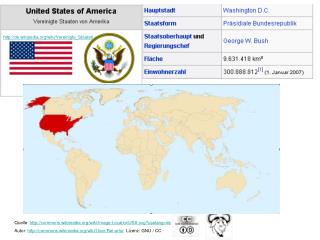
http://de.wikipedia.org/wiki/Vereinigte_Staaten. Quelle: http://commons.wikimedia.org/wiki/Image:LocationUSA.svg?uselang=de Autor: http://commons.wikimedia.org/wiki/User:Rei-artur Lizenz: GNU / CC. http://de.wikipedia.org/wiki/Bild:USA_karte.png.

E N D
http://de.wikipedia.org/wiki/Vereinigte_Staaten Quelle: http://commons.wikimedia.org/wiki/Image:LocationUSA.svg?uselang=de Autor: http://commons.wikimedia.org/wiki/User:Rei-artur Lizenz: GNU / CC
http://de.wikipedia.org/wiki/Bild:USA_karte.png http://de.wikipedia.org/wiki/Werk_der_Regierung_der_Vereinigten_Staaten
Quelle: http://commons.wikimedia.org/wiki/Image:U.S._Territorial_Acquisitions.pngAutor: http://en.wikipedia.org/wiki/User:Black_and_White Lizenz Public domain
Quelle: http://de.wikipedia.org/wiki/Bild:Bev%C3%B6lkerungsdichte_USA.png Autor: Marcel Krüger Lizenz:
Quelle: http://commons.wikimedia.org/wiki/Image:Map_of_USA_showing_state_names.png?uselang=de Autor: User:Wapcaplet Lizenz GNU
http://de.wikipedia.org/wiki/Bild:Chicago-Illinois-USA-skyline-day.jpg Autor: http://en.wikipedia.org/wiki/User:Basho Lizenz GNU
Hauptstadt / Capital USA Washington D.C: Stadt / Cityca. 580 000 (24.) http://de.wikipedia.org/wiki/Washington_%28D.C.%29 Aerial view of Capitol Hill and the National Mall, Washington D.C.. Original source http://teachpol.tcnj.edu/amer_pol_hist/thumbnail506.htmlArchitect of the Capitol's http://commons.wikimedia.org/wiki/Image:Washington_DC_view1.jpg?uselang=de
http://de.wikipedia.org/wiki/Bild:USA_topo.jpg Bei der Erstellung der Landkarte wurden die Generic Mapping Tools verwendet: http://gmt.soest.hawaii.edu/dss.ucar.edu/datasets/ds759.3www.ngdc.noaa.gov/mgg/topo/gltiles.htmlwww2.jpl.nasa.gov/srtm/index.html Autor: http://de.wikipedia.org/wiki/Benutzer:Captain_Blood Lizenz GNU
http://upload.wikimedia.org/wikipedia/en/0/0e/USAClimates.PNGhttp://upload.wikimedia.org/wikipedia/en/0/0e/USAClimates.PNG
Karte „Verbündete ausserhalb Europas“ http://commons.wikimedia.org/wiki/Image:American-MNNAs-2004.png?uselang=de Lizenz Die Vereinigten Staaten sind Gründungsmitglied der NATO, dem derzeit führenden Militärbündnis. Derzeit zählt es 26 Mitglieder aus weiten Teilen Europas sowie Kanada. Kuba West-Sahara Irak/Iran Bhutan Nordkorea Quelle: http://de.wikipedia.org/wiki/Bild:Diplomatic_relations_of_the_United_States.png public domain by its author, Hoshie.