Comprehensive NJ/PA Roadmap with Key Routes and Distance Metrics
This detailed roadmap for New Jersey and Pennsylvania provides essential route information and distance metrics for travelers. Featuring a scale of 1 inch to approximately 11 miles or 17.4 km, it outlines major routes such as Pittsburgh to CBG (approx. 20 miles), CBG to Erie (around 138 miles), and Slippery Rock to CBG (about 62 miles). The map highlights significant locations including state parks, national forests, and important rivers like the Delaware and Susquehanna. Ideal for planning trips and exploring the scenic routes.
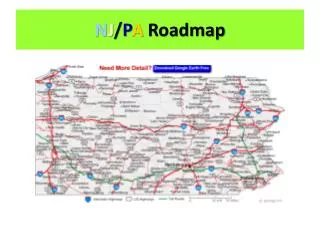

Comprehensive NJ/PA Roadmap with Key Routes and Distance Metrics
E N D
Presentation Transcript
1. Map Scale • 1 in = approx. 11 mi • 1 in = 17.4 km
2. CBG • K-3 • Southwest
3. Pittsburgh to CBG • Less than 30 mi (approx. 20 mi) • Mapquest = 21.67 mi
4. Erie • North • B-4
5. CBG to Erie • Less than 160 mi (approx. 138 mi) • Mapquest = 142.98 mi
6. Shaded yellow • City
7. Ohiopyle River • Youghiogheny R.
8. Youghiogheny R. length (in PA) • Approx. 66 mi N
9. Ohiopyle coordinates • M-6
10. 3 lakes entirely in PA = coordinates • L. Tionesta = E-7 • L. Arthur = G-4 • High Point L. = N-7
11. Slippery Rock to CBG • Approx. 62 mi • Mapquest = 65.72 mi
12. Pitt. To NYC • Approx. 383 mi • Mapquest = 370.87 mi
13. Shaded green areas • State parks & Nat’l./State forests
14. River between PA & NJ • Delaware R.
15. PA river that drains into Chesapeake Bay • Susquehanna R.
16. Green triangle w/in a green circle • Rest area w/ restrooms
17. 2 rivers that form the Ohio R. • Allegheny R. + Monongahela R.
18. Pitt to State College • Merge onto I-376 E/US-22 E toward MONROEVILLE. (Approx. 14 mi) • Merge onto US-22 E/WILLIAM PENN HWY via the exit on the LEFT toward MURRYSVILLE. (Approx. 75 mi) • Merge onto I-99 N/US-220 N via the exit on the LEFT toward ALTOONA. (Approx. 38 mi) • Take the US-322-BR E/ATHERTON ST exit, EXIT 69. (Approx. 11 mi) • Total = approx. 138 mi • Mapquest = 135.8 mi