Early Paleozoic Earth History
430 likes | 1.39k Vues
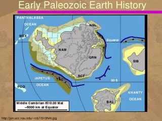
Early Paleozoic Earth History. http://jan.ucc.nau.edu/~rcb7/510NAt.jpg. North American Paleogeography. Broke away from supercontinent ~600 Ma Configuration of supercontinent not well-understood How do we know? Evidence of rifting (divergent margin) Basalt

Early Paleozoic Earth History
E N D
Presentation Transcript
Early Paleozoic Earth History http://jan.ucc.nau.edu/~rcb7/510NAt.jpg
North American Paleogeography • Broke away from supercontinent ~600 Ma • Configuration of supercontinent not well-understood • How do we know? • Evidence of rifting (divergent margin) • Basalt • Subsidence – cooling and thinning of lithosphere
Early Paleozoic Climate of NA • North America in tropical location • End of Snowball Earth • Warmer in Cambrian and Ordovician
Paleogeography • Location of continents and ocean basins constantly changes • Historical geology provides past geologic and paleogeographic reconstruction of the world • Paleogeographic maps show • distribution of land and sea • possible climate regimes • geographic features (mountain ranges, swamps, glaciers)
Early Paleozoic Global History • Cambrian world consisted of six major continents at low tropical latitudes • Water circulated freely among ocean basins, and the polar regions were mostly ice free
Paleogeography of the World • For the Late Cambrian Period
Paleogeography of the World • For the Late Ordovician Period
Paleogeography of the World • For the Middle Silurian Period
Early Paleozoic Evolution of North America • The geologic history of the North American craton may be divided into two parts • relatively stable continental interior over which epeiric seas transgressed and regressed • mobile belts where mountain building occurred • Sedimentary-rock record of NA subdivided into six cratonic sequences
Paleozoic History • The Paleozoic history of most continents • major mountain-building activity along margins • numerous shallow-water marine transgressions and regressions • These transgressions and regressions • caused by global changes in sea level • related to plate activity and glaciation
Cratonic Sequence • A cratonic sequence is • large-scale lithostratigraphic unit • represents a major transgressive-regressive cycle • bounded by unconformities • The six unconformities extend across the North American craton
The Sauk Sequence • Rocks of the Sauk Sequence • Late Proterozoic-Early Ordovician • record the first major transgression onto the North American craton • Deposition of marine sediments limited to the shelf areas of the craton • The craton itself was above sea level
Transcontinental Arch • By the Late Cambrian, Sauk Sea had covered most of North America, leaving above sea level only • a portion of the Canadian Shield • and a few large islands, the Transcontinental Arch, • extended from New Mexico to Minnesota and the Lake Superior region
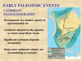
Cambrian Paleogeography of North America • During this time North America straddled the equator • Trans-continental Arch
Cambrian Facies • Sediment derived from craton • Sandy facies occur closest to craton • Quartz-rich sand derived from craton • craton surface weathered and eroded for half a billion years! • no land plants yet – erosion by wind more common • Mature sandstone: well-rounded, well-sorted, 99% Qtz,
Where were they deposited? • Fossils suggest marine environment • No land animals at this time • How do we interpret environment? Use sedimentary structures!
Cross-stratification • Formed by wind or water • Wind – dunes > 1 m high • Water – typically smaller
Cross-stratification 2 m WIND! www.env.duke.edu/eos/geo41/win2.htm and homepage.ntlworld.com/donald.mcintyre/menu_files/stones_files/crossbeds_files/peddie_230.jpg
End of Cambrian • Most of North America underwater • Sauk Transgression • Epeiric sea • shallow inland sea (over continent) • < 200 m deep
Cambrian Transgression • Cambrian strata exposed in the Grand Canyon
Beginning of Ordovician • Very little land remaining above SL • Little terrigenous clastic sedimentation • Shift to carbonate deposition • limestones formed from shell debris • clear, shallow water
Stromatolites • Constrain water depth • need sunlight for photosynthesis • Photic zone – 150-200 m • All evidence suggests very shallow Sauk Sea Shark Bay, Australia http://www.mlssa.asn.au/journals/1999Journal.htm
Regression and Unconformity • As the Sauk Sea regressed during the Early Ordovician, it revealed a landscape of low relief • The rocks exposed were predominately limestones • The resulting craton-wide unconformity marks the boundary between the Sauk and Tippecanoe sequences
Ordovician Period • Paleogeography of North America showing change in the position of the the equator
Orogeny What North American mountain range began to form in the Ordovician? Appalachians
The Taconic Orogeny • Named after present-day Taconic Mountains of • eastern New York • central Massachusetts • and Vermont • First of several orogenies to affect the Appalachian region
Appalachian Area • East coast was passive margin in Early Ordovician – like modern Gulf of Mexico • Changed to active margin in Middle Ordovician • Collision with microcontinent or volcanic arc
Appalachian Mobile Belt • Middle Ordovician transition to convergence resulted in orogenic activity
Orogeny Timing • Volcanic rocks from present-day Georgia to Newfoundland • Clustering of radiometric ages between 440 to 480 million years ago • In addition, regional metamorphism coincides with the radiometric dates
Clastic Wedge Debris eroded from mountains into adjacent basin Thick layer of sediment adjacent to source
Silurian Period • Reefs developed in the Michigan, Ohio, and Indiana-Illinois-Kentucky areas