Download
1 / 35
470 likes | 824 Vues
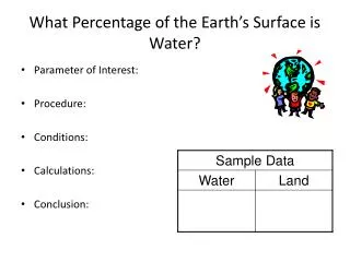
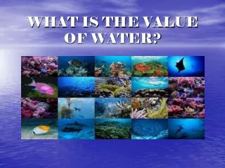
WHAT IS THE VALUE OF WATER?. What percent of the planet is water? How much is fresh water? Where is most of the fresh water? 25% of the world’s drinking water comes from this lake. How many oceans are there? What are the names of the oceans? What percent of your body is water?. ~ 75% 3%

E N D
What percent of the planet is water? How much is fresh water? Where is most of the fresh water? 25% of the world’s drinking water comes from this lake. How many oceans are there? What are the names of the oceans? What percent of your body is water? ~ 75% 3% Icebergs Great Lakes One Atlantic, Pacific, Indian, Arctic, Antarctic ~70% FACTS ABOUT WATER
Earth/ \ 25% Land 75% water / \ 97% salt 3% fresh |/ \ oceans 2% glaciers 1% drinkable / \ coastal (~10%) open sea (90%) │ Contains 90% of all marine species / │ \ coastal wetlands estuaries coral reefs
What impact have humans had on marine ecosystems? • 1,200 marine species have become extinct in past 100 years • Up to ½ all known fish species are threatened with extinction due to: • Overfishing • Habitat destruction • Pollution • ½ wetlands are gone (agriculture/development) • 27% of world’s coral reefs are gone or seriously threatened • 70% could be gone within next 50 years • 70 % beaches eroded due to development and rising sea levels
Ecological Climate moderation CO2 absorption Nutrient cycling Water treatment Reduced storm impact (wetlands) Habitat biodiversity Economic: Food Medicine (coral reefs) Transportation Habitat for humans (coastal) Employment Oil/gas minerals What services do marine ecosystems provide us with?
What is a Riparian Zone? RIPARIAN ZONE RIPARIAN ZONE
Why is a riparian zone important to aquatic ecosystem? • Riparian zones are narrow strips of land bordering lakes, rivers, and other bodies of water • Riparian zones are important for several reasons; • Biodiversity: mammals, fish, amphibians, insects, plants liking moisture • Water quality: traps fertilizers, pesticides, heavy metals, pathogens • Protection against erosion: traps sediments (#1 pollutant in rivers) • Temperature regulation: Riparian plants shield water from sun (thermal pollution) • Property value: beautiful scenery, prevents loss of land, and provides privacy
Environmental: Climate moderation Nutrient cycling Waste treatment Flood control Groundwater recharge Habitat biodiversity Economic: Food Drinking water Irrigation for crops Hydroelectricity Transportation Recreation employment What services do freshwater aquatic ecosystems provide us with?
What is a Watershed? • The simple definitionIt's the area of land that catches rain and snow and drains or seeps into a marsh, stream, river, lake or groundwater.
What are Topographic Maps? • Topographic maps show a 3 dimensional world in 2 dimensions by using contour lines. • Contour lines are curves that connect contiguous points of the same altitude
How do we determine Contour Intervals? • The contour interval measurement is the vertical distance between adjacent contour lines • What is the contour interval on this map? • Determine the altitude of points a, b, c.
What are Hachures? • If a loop instead represents a depression, some maps note this by short lines radiating from the inside of the loop, called "hachures".
What do the Colors Represent? • ColorsThe colors on a topographic map are symbolic of different map features. • Blue = water • Green = forest • Brown = contour lines • Black = cultural features (buildings, place names, boundary lines, roads, etc.) • Red = principal roads • Pink = urban areas • Purple = revisions to an older map, compiled from aerial photos. If an area has become urbanized, this may be shown as purple shading on the new, revised map.
Where does most of our drinking water come from? • An aquifer is an underground layer of water-bearing permeable rock or unconsolidated materials (gravel, sand, silt, or clay) from which groundwater can be usefully extracted using a water well
Where Does All The Water Go? • Municipal/Residential 7% • Industrial 21% • Paper/pulp 10% • Wood/Lumber 6% • Mining/oil/gas 3% • Other 2% • Agricultural 72%
Residential Use Of Water • Lawns 29% • Toilet 29% • Bathing 23% • Laundry 11% • Dishes 6% • Drinking 2%
Can we learn from our mistakes? • Aral Sea Crisis • Location: Russia • Diversion of water to irrigate cotton fields, vegetable, fruit and rice crops has caused: • Tripling of sea’s salinity • Decreasing the sea’s surface area by 54% and volume by 75% • Converting the lake bottom to a human-made desert • Devastated the fishing industry (extinction of 20 out of 24 fish species) • Alteration of climate • Health problems such as throat cancer from toxic dust
Can the Aral Sea be Saved? • Already $600 million has been invested in: • Purifying drinking water • Improving irrigation techniques • Constructing artificial wetlands • However this will take decades for area to improve and this will not prevent Aral Sea from shrinking into a few brine lakes
The shrinking Ogallala Aquifer • The world’s largest aquifer (size of lake Huron) is a nonrenewable resource produced by the last ice age (15,000-30,000years ago) with an extremely slow recharge area due to the clay content in the soil. • It is being depleted much faster than it is able to recharge. • At this rate ¼ of the remaining aquifer will disappear by 2020.
What can be done? • Use more efficient irrigation systems • Gravity flow • Center pivot • Drip irrigation (best) • Switch to crops that need less water • Irrigate less land • Citizens can conserve water
Three Gorges Project • Largest dam project in the world (China) costing $26 billion • One mile long and 575 ft above Yangtze River • Reservoir 350 miles upstream • Scheduled to be completed in 2011 • 32 turbines, 22,500 megawatts • Displace 2 million people
How Does Building Dams Affect The Environment? • Destroys habitats • Displaces people • Causes droughts in other regions • Extremely dangerous if fails • Provides clean power • Controls flooding down river • Provides water
What are Sources of Pollution? • The U.S. Environmental Protection Agency (EPA) defines point source pollution as “any single identifiable source of pollution from which pollutants are discharged, such as a pipe, ditch, ship or factory smokestack”
To drill or not to drill, that is the question? • Oil spills: • Exxon Valdez (1989) in Alaska • Amount spilled estimated 32 million gallons • Double hulled ships to carry oil
Bp “Deepwater Horizon” Spill in Gulf (2010) • Amount spilled: • Some Numbers to think about! • 27 offshore drilling projects approved in Gulf after BP spill • 11 billion gallons of oil spilled each year into oceans • 19.5 million barrels of oil used in US per day • $1.6 billion as of June 2010 used to clean up oil spill
How can we clean up oil spills? • Mechanical: • Floating booms to contain oil • Skimmer boats to vacuum • Absorbant pads (feathers and hair to clean up) • Chemical: • Coagulating agents to cause oil to clump for easier pick up or sink to bottom • Dispersing agents to break oil apart • Fire (but crude oil is harder to burn than refined oil and contributes to air pollution
What is Nonpoint Source Pollution? • Nonpoint-source pollution is another term for polluted runoff. Water washing over the land, whether from precipitation, car washing or watering crops or lawns, picks up an array of contaminants including oil, sand and salt from roadways, agricultural chemicals, and nutrients and toxic materials from both urban and rural areas.
How Can We Clean Up? • Most environmental projects sooner or later will arrive at the remediation or clean-up stage of the project. • Three forms of cleanup: Physical, Biological, Chemical
What is The Clean Water Act of 1972? • It’s goal is to restore and maintain the chemical, physical, and biological integrity of the nation’s waters • All water must be “fishable and swimmable” • Requires discharge permits of major polluters • Identify toxins and use best practical methods to remove pollutants • Set goal for best available technology to be developed in the future
How Can We Control Water Pollution? • Reduce NOx and sulfur emissions • Modify agricultural practices • Separate storm water runoff and septic treatment • Decrease silt runoff (# 1 polluter: holding ponds and permeable surfaces) • Seal Landfills • Stop Ocean Dumping