Download
1 / 15
150 likes | 334 Vues
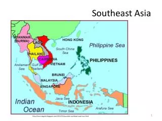
South Asia: Physical Geography. A Separate Land. The seven countries that make up South Asia are separated from the rest of Asia by mountains, making South Asia a Subcontinent Subcontinent – a large, distinct landmass that is joined to a continent

E N D
A Separate Land • The seven countries that make up South Asia are separated from the rest of Asia by mountains, making South Asia a Subcontinent • Subcontinent – a large, distinct landmass that is joined to a continent • Most of the region forms a peninsula of about 1.7 million square miles, being touched by three bodies of water: • The Indian Ocean • The Arabian Sea • The Bay of Bengal
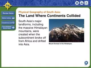
A Land of Great Variety: Mountains • The Himalaya • Formed after the subcontinent broke away from the same large landmass that contained Africa and smashed into the southern edge of Asia. • Extends more than 1,000 miles across the northern edge of the peninsula, and hundreds of mile wide. • Contains Mt. Everest • The world highest peak – rises 29,035 feet above sea level. • The Himalaya meet the Karakoram Mountains in the northernmost part of the region • The Hindu Kush range completes the chain • Over the centuries, the mountains have served as protection from foreign invaders, forcing them through a small number of narrow crossing places (Khyber Pass)
Himalayan Mountains • http://www.sciencechannel.com/tv-shows/wonders-with-brian-cox/videos/wonders-of-the-universe-himalayan-mountains.htm
A Land of Great Variety • Central Landforms • The same collision that created the Himalaya also created the Vindhya (ˈvin-dyə, -dē-ə) Range in India • This range divides India into its northern and southern regions • These Regions each have their own distinct cuisine, architecture, and religious practices • Southern Land Forms • Eastern & Western Ghats (gawts, gots) • Eroded mountains in southern India • Between them lies the Deccan Plateau • The Western Ghats prevents yearly rainy winds from reaching the plateau • Instead the Karnataka Plateau receives the rain.
Major River Systems • Indus River • Flows mainly through Pakistan, and empties in the Arabian Sea • Serves as an important transportation route • Known as the “cradle” of ancient India • Brahmaputra (brah-muh-poo-truh) River • Flows east through the Himalaya, then west into India and Bangladesh • There it joins the Ganges – to form a delta before emptying into the Bay of Bengal • Serves as an important inland transportation route • Provides Bangladesh with 50% of its power through hydroelectricity
Major River Systems • Ganges River • Flows east from the Himalaya • Most important river in South Asia • The land area through which the river flows is called the Ganges Plain • Almost all of this land is used for crops (rice, sesame, sugarcane, jute, and beans) • World longest alluvial plain – an area of fertile soil deposited by river flood waters • Also is India’s most densely populated area
Environmental Concerns: Ganges River • http://video.nationalgeographic.com/video/specials/in-the-field-specials/cousteau-ganges-kampur-threats/ • End 3:40
Natural Resources • Energy Resources • Petroleum • Reserves near Ganges Delta, and northern Pakistan • Overall South Asia is dependent on imported oil • Natural Gas Fields • Southern Pakistan • Ganges Delta Region • Bangladesh • Uranium • India – north of the Eastern Ghats • Hydroelectricity
Minerals • India • Leading exporter of iron ore • Supplies 90% of world’s mica – a layered rock used in making electrical equipment • Nepal • Mica • Small amounts of copper • Sri Lanka • One of world’s largest graphite producers • Sapphires, Rubies, and other precious stones
Timber • Timber is an important part of South Asia’s economy • Forests of Nepal and Bhutan (bü-ˈtän, -ˈtan) • Silver fir, oak, magnolia, beech, and birch • India • Sandalwood, sal, and teaks woods