Using GPS data for IFTA and IRP
410 likes | 514 Vues
Using GPS data for IFTA and IRP. Objective. Controls in an IT Environment GPS – How it Works? Applying Knowledge Gained to Future Audits. IT Controls. Subset of enterprise’s internal controls. Objective is confidentiality, integrity, availability of the data. General Controls

Using GPS data for IFTA and IRP
E N D
Presentation Transcript
Objective • Controls in an IT Environment • GPS – How it Works? • Applying Knowledge Gained to Future Audits.
IT Controls • Subset of enterprise’s internal controls. • Objective is confidentiality, integrity, availability of the data. • General Controls • Application Controls
General Controls: Change management procedures Security Policies, Standards and Processes Disaster Recover Application Controls: Completeness Checks. Validity Checks Authorization Input Controls
IRP 502 & IFTA P620(Printed Reports) • Printed reports must be produced which replace handwritten trip reports. • Retained for audit • Vehicle and fleet summaries.
IRP 504 & IFTA P660(Minimum Device Requirements) • Manufacturer certification. • Security – tamperproof and prevent altering of information. • Functionality – warnings if devices quits. • Date and time stamping. • Automatic update a life-to-date odometer or operator enters odometer.
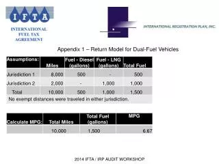
IRP 505 & IFTA P640(Data Collection Requirements) • Distance (IFTA and IRP) • Fuel (IFTA)
IRP 506 & IFTA P650(Reporting Requirements) • Trip Reports • Individual Vehicle Reports • Summary Reports (Monthly, Quarterly, Annual) • Exception Reports • Calibration Reports
How does GPS work? • 24 + satellites orbit the earth searching for GPS receivers • When a receiver is in contact with three or more satellites, the location of the receiver is determined • This location is expressed in Latitude and Longitude and is stored along with the precise time of its calculation
How does GPS work? • The GPS receiver is attached to a micro computer which takes the information, interprets it, then stores it or passes it on to a communications device
How does GPS work? GPS satellites GPS Receiver Micro Computer
How does GPS work? • The GPS data is sent to a computer (perhaps a server) and is available for calculating distance reports for use in Tax and Licensing
How does GPS work? GPS satellites Internet Communication Modem GPS Receiver Micro Computer
NOTE • GPS satellites are “one-way” – Satellite to ground • GPS satellites are free!! • For wireless communication we use different satellites or cellular systems
How does GPS work? • These GPS points can be calculated as frequently as once per second which allows a precise calculation of speed and direction of travel • In most systems, not all of these points are stored. The recording interval could be from two minutes up to an hour. • The shorter the interval, the larger the number of points and the greater the accuracy.
Accuracy of GPS • Can be accurate to within a few inches but only with sophisticated / expensive receivers • For our purposes – within 20 feet is reasonable • Filters and algorithms have been developed to minimize distortions in the data • Accuracy in measuring routes of travel increases with the frequency of recording • For example, if points are recorded every 5 minutes it is more accurate than every 30 minutes
Methods of calculating distance • Use the continuous distance calculation (every second) and accumulate distance which can be added to recorded points. • Calculate straight-line distances between recorded points. • Get distances from an external source such as an odometer or a “Miler” program
Distance Calculation Frequent Data Records • If straight-line calculations are used with infrequent data records, the distance may be under reported • If continuous calculations are used (every second), then the frequency of recording is less important. Infrequent Data
Assigning distance to Jurisdictions • Data could be run through a Miler program which assigns the distance to each jurisdiction. • Distribution of distances can be done by the use of “Geofencing”.
Use of geofencing • Describe a polygon using Lat and Long • Use an algorithm to determine when a truck enters or leaves a polygon • Set up all states and provinces as contiguous polygons • Calculate the distance traveled in each jurisdiction (polygon)
Routing Problem Actual Travel Routed by Miler
GPS data auditors might ask for • Minimum for all recorded data points • Latitude • Longitude • Date/time • Additional • Method used for distance calculations • Odometer to check reasonableness • Method used to distribute distances