Download
1 / 32
320 likes | 442 Vues
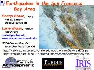
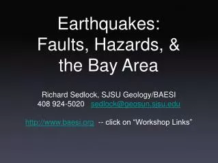
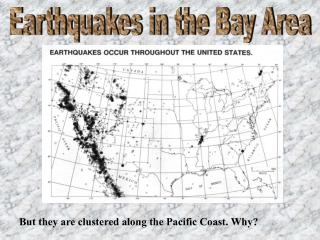
Earthquakes in the Bay Area. But they are clustered along the Pacific Coast. Why?. California and the San Andreas Fault. Movement along the San Andreas Fault Tectonic Creep is the slow continuous movement along a fault zone that is not accompanied by felt earthquakes.

E N D
Earthquakes in the Bay Area But they are clustered along the Pacific Coast. Why?
California and the San Andreas Fault
Movement along the San Andreas Fault • Tectonic Creep is the slow continuous movement along a fault zone that is not accompanied by felt earthquakes. • Locked faults are sections that are not moving. They may be locked due to friction. Pressure builds up in these sections until the it overcomes the friction and the energy is released in an earthquake.
A. Seismicity (1969-89) before Loma Prieta San Jose could be next! B. Loma Prieta earthquake and aftershocks
Cross-section of Loma Prieta Earthquake Dip 70 º 25-miles There were 4,760 aftershocks
Loma Prieta fault-line is sloping. 6.2 ft 4.3 ft The pacific plate moved 6.2 feet northwest and 4.3 feet upward.
When will the Big One strike ? There is a 67% chance that an Earthquake of a magnitude of 7 or greater will strike the Bay area in the next 30 years. It is likely to strike north of the Loma Prieta Earthquake somewhere between San Jose and Santa Rosa on either side of the Bay. It is also likely to have an epicenter in an Urban area. But Southern California is more likely to have a large earthquake like the San Francisco 1906. (8.3) Are You Ready?
Earthquake Damage depends on many factors: The size of the Earthquake The distance from the focus of the earthquake The types and properties of the materials at the site The nature of the building
Soil and Earthquake Damage: • soil thickness:shallow soils may not perform as well as deep • Soil saturation: saturated soils perform less well than dry • Soil grain size and sorting: well-sorted, fine grained sands and silts are the most likely to liquefy • Types of bedrock: unweathered igneous rocks are better than weak fractured rock • Areas where ground may settle or slide • soft soil, mud or reclaimed land are most likely to liquefy • Nature of building and Earthquake Damage: • Type of construction • Seismic design considerations • Size and use of building • Architectural simplicity of building
Measuring Earthquake Intensity and Magnitude The strength of an Earthquake can be measured in two different ways (see pages 169-172 in text) Intensity: is a qualitative assessment of the kinds of damage done by an earthquake it is subjective Modified Mercalli Intensity scale ( I to XII) Magnitude: is a quantitative measurement of the amount of energy released by an earthquake Richter Magnitude scale (open-ended scale) each step in the richter scale is a increase 10-fold in movement a 30-fold increase in energy
Earthquake risk in the Bay Area Green: Stable bedrock Orange: Unstable bedrock Yellow: Unconsolidated Soil Red: Mud and Fill
Impact of 1906 Earthquake on San Francisco
Earthquake Prediction It is difficult to accuratly predict earthquakes. Analysis of past earthquake patterns, measurement of movement, and the distribution of faults have allowed scientists to create seismic risk maps. Along the San Andreas fault geologists are looking for areas along active faults that are currently active. This probably means that these regions are locked and that energy is building up. Tilting of rocks on either side of fault-lines is also a sigh of pressure build-up.
Ways in which faults can move • Normal fault • Thrust fault • Lateral slip
Features associated with the San Andreas Fault • Fault Scarps • Steep mountain fronts • Offset streams (Dogleg streams) • Sag ponds and lakes • Valleys in fault zones • Changes in rock type
Offset fence Point Reyes
Fault Scrap Central California scarp Linear valley Linear ridge Offset stream
Displacement of rocks by a fault-line Qos Tnv Tnv Tnv
Strike slip movement in New Zealand = volcano = strike-slip fault = convergent plate boundary The alpine fault which runs through the south island of New Zealand has both strike-slip and vertical movement. 450 km
Earthquakes and the Earth's Interior The movement of Earthquake waves through the Earth’s interior has given us a better picture of the earth’s interior.
P-waves are faster than S-waves. The density and elasticity of rock affects the speed of the waves. When p-waves hit the core, they are refracted and slow down. This creates a P-wave shadow 103º -143 º from the focus
S-waves can’t travel through liquids. When S-waves hit the outer liquid core, they stop. This creates a S-wave shadow at locations greater than 103º from the focus of the earthquake.
Earthquakes have even shown the depth of the crust. A sharp boundary between the crust and the upper mantle at about a depth of 30km exists. P-waves travel at 6.75 km/sec in the crust and 8 km/sec below this boundary. The depth of this boundary varies depending if it is under continents (20 - 90 km) or under ocean floors (5 to 10 km). The speed of sesmic waves increases with depth in the mantle except for a low velocity zone at 100-250 km, this corresponds to the asthenosphere.