Download
1 / 22
220 likes | 396 Vues
GEOSS ADC Architecture Workshop. Hosted by the European Commission At the Joint Research Centre February 4, 2008. Breakout Session 1b: Inter-calibration Scenario - Stephen Ungar. GEOSS Harmonization of Sensor Observations.

E N D
GEOSS ADC Architecture Workshop Hosted by the European Commission At the Joint Research Centre February 4, 2008 Breakout Session 1b: Inter-calibration Scenario - Stephen Ungar
GEOSS Harmonization of Sensor Observations The Global Earth Observing System of Systems (GEOSS) is to be a global, coordinated, comprehensive and sustained system of earth observing systems. The GEOSS architecture is being designed to facilitate coordinated access to data and products produced amongst all contributing systems. However, to effectively exploit information derived from disparate data sources, it is necessary to introduce consistency of content through guidelines to data providers for the appropriate characterization of the observing systems and their derived products. Ultimately, consistency can be provided through standardized “best practices”
Workshop Session 1b This session seeks interaction across the GEO Community to identify standards and best practices for: calibrating and validating sensors. We will start a dialog on what is needed to characterize sensor capabilities in a manner which satisfies GEO needs. Furthermore, we will explore how the Architecture Implementation Pilot can facilitate the CEOS Cal/Val Portal, as well as how the Cal/Val Portal can contribute to meeting the objectives AIP.
Coordination with GEO and related tasks: • DA-06-02 (Data quality assurance strategy for space-based and related in-situ observations) • CL-06-02 (Key Climate Data from Satellite Systems) • DA-07-04 (Sensor Web Enablement for In-Situ Observing Network Facilitation) • DA-07-05 (Higher Level Data Product Tools) • WE-06-02 (Space-based Global Observing System for Weather) • CEOS WGCV (Committee on Earth Observation Satellites, Working Group on Calibration and Validation)
Refining the GEO Data Quality Framework Over the past three years, the CEOS WGCV, in conjunction with participants in DA-06-02, has developed a Data Quality Framework (DQF) for GEO. The CEOS Cal/Val Portal, a prototyping activity, designed to test and refine the guidelines presented in the DQF, has been instituted under ESA sponsorship. This activity is an extension of the historic (and extensive) participation in the WGISS Test Facility (WTF) by WGCV. This task was the principle topic of the GEO-CEOS Quality Assurance Workshop held at the GEO Secretariat in Geneva last October. A follow-up workshop is to occur at NIST in Gaithersburg, Maryland during the first week of May. A scenario involving the use of a common Antarctic Cal/Val site (Dome C) for selected optical and microwave observing systems from several national agencies, will be introduced at the Joint WGCV/WGISS Plenary to be held in Sanya China during the last week of February
Breakout Sessions – Summary Findings I • A narrow spectrum of Users • End Users are actually the Providers • Validaters will focused on source and quality of data • Users versus Providers • Encourage connectivity between the two and between models and data providers • Iterative, interactive feedback from users & ability to correct errors • Modeling • Common approach to producing data used for inter-comparisons • Key data characteristics • Static data consists “best practices” documentation and observing systems descriptions/characterizations • Tentative data consists of initial deposits of observations of validation sites and preliminary calibration parameters/coefficients
Breakout Sessions – Summary findings IIEmphasis on Data • Frequently mentioned concerns • Access to initial data restricted to Cal/Val participants • Traceability absolutely required • Common practices in processing highly desired • Full disclosure if you wish to participate • Data distribution mechanism • CEOS-GEO Cal/Val Portal provides entry point for inter-comparison data resides on provider’s server • Portal hosts forum to provide feedback • Test Case: encourage providers to acquire data from a subset of proposed CEOS WGCV validation sites and supply these data to The CEOS-GEO Cal/Val Portal forevaluation purposesInitial test site is Dome-C in Antarctica … multiplatform, multi-national and multi agency
Road Map for proposed activitiesaddressing task GEO DA-06-02
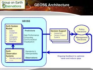
Policy Decision Management Decision BackgroundGEOSS Architecture • Earth System Models • Oceans • Ice • Land • Atmosphere • Solid Earth • Biosphere Predictions Societal Benefits High Performance Computing,’ Communication, & Visualization Decision Support Assessments Decision Support Systems • Earth Observation • Systems • Remotely sensed • In situ Standards & Interoperability Observations From: The Architecture of GEOSS (GEO4DOC 4.1 [2]; April 5, 2004)
Policy Decision Management Decision BackgroundGEOSS Information Flow • Earth System Models • Oceans • Ice • Land • Atmosphere • Solid Earth • Biosphere Predictions Societal Benefits High Performance Computing,’ Communication, & Visualization Decision Support Assessments Decision Support Systems • Earth Observation • Systems • Remotely sensed • In situ Standards & Interoperability Observations
GEOSS Information Architecture The WGCV GEOSS Information Pyramid Cal/Val strengthens the base as shown in the following slides Societal benefits Decisions policy management Recommendations Decision support: Assessments and Systems Predictions Earth System Models:Atmosphere, Oceans, Ice, Land/Biosphere Data, Standards and Interoperability Earth Observation Systems Remote Sensing observations In situ surveys and measurements
BackgroundComponents of GEOSS Architecture Global Earth Observation System of Systems GEOSS architecture builds incrementally on existing systems to create a distributed system of systems, incorporating: • an observation component • a data processing and archiving component • a data exchange and dissemination component Observation Component Data Processing Component Data Exchange and Dissemination Component From: The Architecture of GEOSS (Global Earth Observation System of Systems); GEO4DOC 4.1 (2); 4.5.2004
BackgroundComponents of GEOSS Architecture Global Earth Observation IndividualSystem GEOSS architecture builds incrementally on existing systems to create a distributed system of systems.WGCV activities contribute to the following GEOSS components: • Observation component • Data processing and archiving component To ensure: • data and products interoperability, exchange and dissemination Observation Component Data Processing Component Data Exchange and Dissemination Component
Inadequate Cal/Val in GEOSS Architecture Global Earth Observation System of Systems Observation Component Data Processing Component Data Exchange and Dissemination Component Observation Component Data Processing Component Data Exchange and Dissemination Component Observation Component Data Processing Component Data Exchange and Dissemination Component Observation Component Data Processing Component Data Exchange and Dissemination Component What’s missing in this scenario? A simplistic view of a System of Systems results in the need to deal with potentially disparate information forcing policy makers to “choose” their outcomes.
WGCV contribution to GEOSS Architecture Global Earth Observation System of Systems Observation Component Data Processing Component Data Exchange and Dissemination Component Observation Component Data Processing Component Data Exchange and Dissemination Component Observation Component Data Processing Component Data Exchange and Dissemination Component Observation Component Data Processing Component Data Exchange and Dissemination Component Calibration / Validation Component Role of WGCV in a true System of Systems where the operating space must cut across individual Systems to provide integrated data for decision models
Inadequate Cal/Val in GEOSS Architecture Global Earth Observation System of Systems Observation Component Data Processing Component Data Exchange and Dissemination Component Observation Component Data Processing Component Data Exchange and Dissemination Component Observation Component Data Processing Component Data Exchange and Dissemination Component Observation Component Data Processing Component Data Exchange and Dissemination Component Calibration / Validation Component Inadequate integration of data sources can lead to disparate model outcomes, introducing uncertainty into the decision process
Establishing Calibration and Validation guidelines is a necessary ingredient in achieving Data Interoperability WGCV proposes to establish Calibration and Validation guidelines, to ensure interoperability of GEOSS member satellite data sources, based on the current space agencies collaboration agreements, common formats and standards. • WGCV proposes that all GEOSS partners participate in the establishment of the following common practices: • Document the methodologies used to derive and further process satellite measurements. • Create and maintain, in conjunction with WGISS, an internet-accessible information database containing, on an instrument or satellite basis, links to all instrument characteristics needed for insuring inter-operability. • Provide/publish Cal/Val reference methods in a readily accessible form. These activities will ensure that the various data are integrable.
ElaborationComponents of GEOSS Architecture Global Earth Observation System of Systems Observation Component Data Processing Component Data Exchange and Dissemination Component The high level GEOSS architecture is a componentization of a structure required to accomplish the GEOSS objectives which is consistent with the structure of most contemporary Earth Observing data systems. There is a need to define the components of GEOSS functionality required to enable the fulfillment of GEOSS objectives through this architecture.
Further elaborationComponents of GEOSS Functionality GEOSS Technical Task Areas GEOSS Data Quality Framework Data Compliance with Interoperability Requirements User Community Dissemination The high level GEOSS functionality componentization introduces a structure whch ensures accomplishment of required GEOSS objectives within the proposed GEOSS architecture. There is a need to specify functionality for the components of GEOSS architecture to enable the fulfillment of GEOSS objectives through this architecture. These components are designed to ensure data integrability and interoperability.
GEOSS Data Quality Framework (Internet accessible through GEOSS Cal/Val website) WGCV Proposal Instrument characteristics (Radiometry, Spectral resolution, Geometry) Sensor Intercomparison Satellite data, in-situ measurements, and metadata Reference Methods and protocols (Cal./Val Techniques) Compliance with Interoperability Requirements Global standards, Global products, Global information base for management decisions Users (Commercial Community, Operational Agencies and Policymakers)
WGCV Proposal WGCV ProposeGEOSS Cal/Val Data Framework Sensor Intercomparison Database Satellite data, in-situ measurements, and metadata Diagnostic sites (land/sea/atmosphere) Calibration Metrics Ancillary information networkse.g. AERONET Database In-situ data Database Sensor data
WGCV: Working Group on Calibration & Validation • Conclusion • The approach outlined in the WGCV White Paper entitled “Data Quality Guidelines for Satellite Sensor Observations Relevant to GEOSS: Calibration and Validation Issues” has been crafted to ensure the quality assessment of space-borne instrument data in the context of a service driven global operational Earth observation remote sensing system. • This approach exploits ongoing work and available expertise among the CEOS working group members, and provides a mechanism for further development over the 10-year timescale of the GEOSS Implementation Plan.