Download
1 / 52
530 likes | 721 Vues
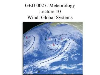
GEU 0027: Meteorology Lecture 10 Wind: Global Systems. Global Circulation. In the absence of rotation , air would tend to flow from the equator toward the poles. Hot, less dense air rising at the equator, becomes denser as it cools and descends at the poles, traveling

E N D
Global Circulation • In the absence of rotation, air would tend to flow from the equator toward the poles. Hot, less dense air rising at the equator, becomes denser as it cools and descends at the poles, traveling back to tropical areas to heat up again.
Global Circulation • Because of earth’s rotation we have several circulation cells not just one per hemisphere
Three-cell Model • With the 3 cell structure of wind circulation and the combination of PGF and Coriolis, semi-permanent circulation patterns are established.
Semi-permanent Pressure and Winds Semi-permanent structures in the atmosphere provide consistent wind patterns and breeding grounds for air masses.
Intertropical Convergence Zone • ITCZ • Hot equatorial air rises in convection. • Air moves away from the equator toward the poles. • Low Pressure results around the equator. • A band of convective thunderstorms circles the tropical areas of the globe.
ITCZ • Equatorial Cumulus and Thunderstorms
Jet Locations Jet stream locations greatly affect local and global climate.
Jet Formation Sharply varying pressure and temperature differences create the exaggerated situation shown. Tightly packed isobars create stronger winds aloft in the frontal region.
Polar Jet Winds are Westerly and parallel to the frontal boundary. This creates the polar jet stream. It is strongest in the winter and weakest in the summer.
Seasonal Polar Jet Changes • Location and Velocity variations
What cause the jets? • L = m v r • r = distance from rotational axis • m = mass • v = velocity
Jupiter’s Bands • Higher Angular Momentum, Yields more zones?
Wind Jets • Other jet formation mechanisms are less well known.
The Dishpan Experiment • Uneven heating of the equator and poles of the earth. • Rotation. • Viscosity and turbulence.
Rossby Waves Kinking in the jet stream occurs on a cyclic basis. Weather patterns are also somewhat cyclic.
Rossby Cycle A complete Rossby cycle observed over ~ 6 weeks.
Normal South Pacific Condition • Easterly “trade-winds” usually prevail and upwelling occurs • When exceptionally strong this cooling is called a La Nina.
El Nino • During an El Nino, pressure conditions (and winds) reverse. • Extremely warm water and wind reversal affects weather.
Sea Surface Temperatures A warm water wave migrates eastward during and El Nino as upwelling and cooling is severely diminished along the western coast of S. America.
El Nino and La Nina events, and ENSO Cycle • La Nina versus El Nino conditions over the past 60 years. • The Y-axis is a parameter calculated from a combination of: • air temperature • water temperature • air pressure (sea-level) • wind speed and direction • cloud cover