Enhancing OSM Data Workflow with JOSM and RLIS Integration
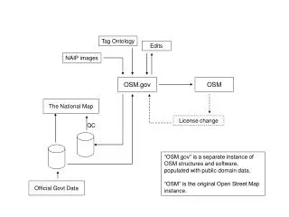
This document outlines the procedure for integrating RLIS attributes into OpenStreetMap (OSM) using JOSM. It describes the steps to create a reclass file, manage mapping layers, and utilize the "paste tags" tool effectively. The workflow includes merging nodes to connect new ways with existing OSM networks and ensuring data integrity by tracking changes with diff files. This guide is essential for contributors aiming to enhance OSM's geographic information and maintain accurate data representation, particularly for regional travel options.

Enhancing OSM Data Workflow with JOSM and RLIS Integration
E N D
Presentation Transcript
RLIS=Blue Diff File & OSM = Red JOSM Editing Session
Copy RLIS attributes into OSM using “paste tags” tool Copy OSM tags back into RLIS attributes to capture complete set
3. Copy RLIS feature and paste geometry (with attributes) into OSM File Note that this way is now red indicating that it belongs to the OSM Data Layer
Delete old OSM feature geometry and DIFF geometry to track progress
5. Merge nodes: connect the newly added ways to the existing OSM node network
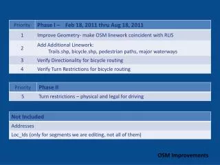
Metro Regional Travel Options Grant July 1, 2011 – July 1, 2013 Open Trip Planner Phase II