Download
1 / 10
100 likes | 285 Vues
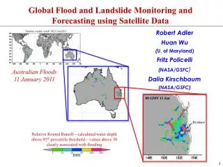
Global Flood and Landslide Monitoring and Forecasting using Satellite Data . Robert Adler Huan Wu ( U. of Maryland) Fritz Policelli (NASA/GSFC ) Dalia Kirschbaum (NASA/GSFC). Australian Floods 11 January 2011. 00 GMT 11 Jan. Brisbane.

E N D
Global Flood and Landslide Monitoring and Forecasting using Satellite Data Robert Adler Huan Wu (U. of Maryland) Fritz Policelli (NASA/GSFC) Dalia Kirschbaum (NASA/GSFC) Australian Floods 11 January 2011 00 GMT 11 Jan Brisbane Relative Routed Runoff—calculated water depth above 95th percentile threshold—values above 50 clearly associated with flooding mm
Three Related Projects in Estimating Floods and Landslides from Space • Monitoring global floods using satellite rainfall and a hydrological model 2. Monitoring global flood extent using satellite imagery (e.g., visible from MODIS and Synthetic Aperture Radar [SAR]) 3. Estimating landslide occurrence globally using satellite rainfall and surface data
We now have the ability to accurately monitor heavy rain events globally Tropical Rainfall Measuring Mission (TRMM) TRMM Multi-Satellite Precipitation Analysis (TMPA/3B42) 3-hr, 0.25° lat./long/ resolution-data available ~ 6 hrs after observation
Australian Floods January 2011 Relative Routed Runoff—calculated water depth above 95th percentile threshold—values above 50 clearly associated with flooding Global A global hydrological model uses satellite rainfall and other information to calculate stream flow and water depth. Thresholds based on historical runs are used to set flood thresholds locally mm 00 GMT 11 Jan Regional “Local” Brisbane Relative to 95% Level (mm)
We Can Monitor Flood Evolution—Is the flood getting worse? Australian Floods 9-13 January 2011 00 GMT 10 Jan 12 GMT 11 Jan 00 GMT 9 Jan 00 GMT 11 Jan Brisbane 12 GMT 12 Jan 00 GMT 13 Jan 00 GMT 12 Jan mm
Automated Flood Mapping Using MODIS Data—complements hydrology calculations just shown Distribution Products: MODIS Flood Map (MFM) 10° tile png graphic
Geographic Tiles Automatically Produced and Available for Use Distribution: OAS website http://oas.gsfc.nasa.gov/floodmap • Specific tile: • date selection • adjacent tile navigator Continental tile overview
Global LandslideNowcasting Rainfall Data: TRMM Multi-Satellite Precipitation Analysis (TMPA) 0.25° pixel resolution, 3-hourly • Surface Data: • Topographic • variables • Land cover • Soil Type and • Texture • Drainage Density Circles enclose small areas of estimated landslide activity
Example of Landslide Nowcast/Forecast Typhoon Morakot (Etau) August 8, 2009 Numerous and massive landslides throughout Southern and Central Taiwan. Over 500 people killed in ShiaoLin We can estimate areas of high potential for landslides using satellite rainfall and surface information
Summary and Future Work • Global flood and landslide estimation and observation has achieved initial success. However, significant room for technical improvement, operation readiness, transfer of information and techniques to under developed countries and scientist and disaster management training Improvements Needed • Improved precipitation information via time-space integration, geo-IR, • ancillary data, model input, Global Precipitation Measurement (GPM) • mission [2014] • Big issue is shallow orographic rainfall—passive techniques tend to underestimate significantly • Improved global hydrological and landslide modeling via finer • resolution, possible nested approach, regional and basin tuning, accounting • for water management (dams), inclusion of snow melt processes • Automated flood mapping will improve via corrections for mountain and • cloud shadows and use of space radar data to “see” through clouds • Use of NWP precipitation information in both global and regional context— • as models improve joint use of satellite and model rainfall for flood and • landslide applications will also improve