Download
1 / 75
780 likes | 1.31k Vues
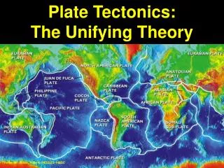
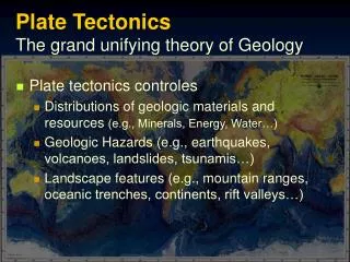
Plate Tectonics The grand unifying theory of Geology. Plate tectonics controles Distributions of geologic materials and resources (e.g., Minerals, Energy, Water…) Geologic Hazards (e.g., earthquakes, volcanoes, landslides, tsunamis…)

E N D
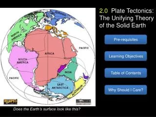
Plate TectonicsThe grand unifying theory of Geology • Plate tectonics controles • Distributions of geologic materials and resources (e.g., Minerals, Energy, Water…) • Geologic Hazards (e.g., earthquakes, volcanoes, landslides, tsunamis…) • Landscape features (e.g., mountain ranges, oceanic trenches, continents, rift valleys…)
Birth of the Solar System Nebular Theory(pg. 24, Kehew) Rotating nebula contracts Begins to flatten and collapse into center to form the sun. Clusters of asteroids coalesced to form planetesimals and moons (planetary accretion) around 4.6 billion years ago (bya) (Meteorites are iron-rich or rocky fragments left over from planetary accretion) Formation of Earth http://www.psi.edu/projects/planets/planets.html
Orion Nebula www.hubblesite.org www.geol.umd.edu/~kaufman/ ppt/chapter4/sld002.htm www.psi.edu/projects/ planets/planets.html
Formation of the Planets Terrestrial Planets • The mass of the center of the solar system began nuclear fusion to form the sun • The inner planets were hotter and gas was driven away leaving the terrestrial planets (Fe, O, Si, Mg…) • The outer planets were cooler and more massive so they collected and retained the gasses forming the “Gas Giants” Gas Giants www.amnh.org/rose/backgrounds.html
Differentiation of the Planets • The relatively uniform iron-rich proto planets began to separate into zones of different composition: 4.5 bya • Heat from impacts, pressure and radioactive elements cause iron (and other heavier elements) to melt and sink to the center of the terrestrial planets (Kehew Fig. 2-4) Lab. Man., Fig. 1.7a: Zones of the earth’s interior
Deepest Mine Deepest Well Further Differentiation of Earth Continental Crust (Silicic) Oceanic Crust (Basalt) • Lighter elements such as Oxygen, Silicon, and Aluminum rose to form a thin, rigid crust • The crust, which was originally thin and basaltic (iron rich silicate), further differentiated to form continental crust which is thicker, iron poor, silica rich and lighter Mid-Ocean Ridge (New Crust) Kehew Fig. 2.5
Element (Atomic #) Chemical Symbol % of Earth % of Crust (by Weight) Change in Crust Due to Differentiation Oxygen (8) O 30 46.6 Increase Silicon (14) Si 15 27.7 Increase Aluminum (13) Al <1 8.1 Increase Iron (26) Fe 35 5.0 Decrease Calcium (20) Ca <1 3.6 Increase Sodium (11) Na <1 2.8 Increase Potassium (19) K <1 2.6 Increase Magnesium (12) Mg 10 2.1 Decrease All Others ~8 1.5 Composition of Earth and Crust
Crust and MantleLithosphere and Asthenosphere • The uppermost mantle and crust are rigid, solid rock (Lithosphere) • The rest of the mantle is soft and solid (Asthenosphere) • The Continental Crust “floats” on the uppermost mantle • The denser, thinner Oceanic Crust comprises the ocean basins
Rocks and SedimentProducts of an Active Planet Crust: Rigid, Thin Earth’s structure leads to intense geologic activity • Inner core: Solid iron • Outer core: Liquid iron, convecting (magnetic field) • Mantle(Asthenosphere): Solid iron-magnesium silicate, plastic, convecting • Crust(Lithosphere):Rigid, thin • O, Si, Al, Fe, Ca, Na, K, Mg… Mantle: Plastic, Convecting 47%, 28, 8, 5, 4, 3, 3, 2
Pangea 225 million years ago 135 mya 65 mya Today
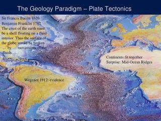
Evidence of Continental Drift • Glacial striations match across oceans Kehew, Fig. 2.27
Evidence of Continental Drift • Matching rock types and mountain ranges Kehew, Fig. 2.27
Evidence of Continental Drift • Fossils of land plants and animals
Evidence of Continental Drift • Magnetic Evidence • Reversals in Earth’s magnetic field are recorded in newly formed rocks Kehew, Fig. 2.7
Evidence of Continental Drift • Age of Earth’s Oceanic Crust Kehew, Fig. 2.32
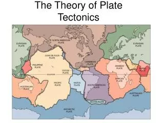
Lithospheric Plates • The Lithosphere is broken into “plates” (7 maj., 6 or 7 min.) • Plates that “ride around” on the flowing Asthenosphere • Carrying the continents and causing continental drift See Kehew, Figure 1.19
Lithospheric Plates Kehew, Fig 2.24
Three Types of Plate Boundaries • Divergent | • Convergent | • Transform e.g., Pacific NW See Kehew, Fig. 2.38
DivergentPlate Boundaries • Where plates move away from each other the iron-rich, silica-poor mantle partially melts and • Extrudes on to the ocean floor or continental crust • Cool and solidify to form Basalt: Lithosphere Lithosphere Simplified Block Diagram Asthenosphere Iron-Rich, Silica-Poor, Dense Dark, Fine-grained, Igneous Rock
Characteristics ofDivergent Plate Boundaries • Divergent Plate Boundary • Stress • Earthquakes • Volcanism • Rocks • Features Lithosphere Asthenosphere See Kehew, Fig. 2.29 New Oceanic Crust Forming at Mid-Ocean Ridge Fissure Eruptions Shallow Earthquakes Oceanic Crust Dark, Dense,Basalt Magma Generation Lithospheric Plate Movement Welling up of hot mantle rock (solid but soft)
Characteristics ofDivergent Plate Boundaries • Divergent Plate Boundary • Stress: Tensional extensional strain • Volcanism: non-explosive, fissure eruptions, basalt floods • Earthquakes: Shallow, weak • Rocks: Basalt • Features: Ridge, rift, fissures Oceanic Crust Magma Generation
Locations of Divergent Plate BoundariesMid-Ocean Ridges (Mid-Arctic Ridge) • East Pacific Rise • Mid Atlantic Ridge • Mid Indian Ridge • Mid Arctic Ridge Fig. 1.10 Mid- Mid-Atlantic Ridge East Pacific Rise Indian Ridge See Kehew, Figure 2.24
Divergent Plate Boundaries 0 33 70 Rifting and generation of shallow earthquakes (<33km) 0 30 150 70 150 300 300 500 500 800 Depth (km)
E.g., Red Sea and East African Rift Valleys • Fig. 19.21 • Fig. 19.22 Thinning crust, basalt floods, long lakes Shallow Earthquakes Linear sea, uplifted and faulted margins Rift Valley Rift Valley Oceanic Crust Passive continental shelf and rise See Kehew, Figure 2.33
ConvergentPlate Boundaries • Where plates move toward each other, oceanic crust and the underlying lithosphere is subducted beneath the other plate (with either oceanic crust or continental crust) • Wet crust is partially melted to form silicic (Silica-rich, iron-poor, i.e., granitic) magma • Stress: Compression • Earthquakes • Volcanism • Rocks • Features Oceanic Trench Volcanic Arc Plate Movement Lithosphere Lithosphere Subducted Plate Magma Generation Simplified Block Diagram Shallow and Deep Earthquakes Asthenosphere
Convergent Plate Boundarye.g., Pacific Northwest • Volcanic Activity • Explosive, Composite Volcanoes (e.g., Mt. St. Helens) • Arc-shaped mountain ranges • Strong Earthquakes • Shallow near trench • Shallow and Deep over subduction zone • Rocks Formed • Granite (or Silicic) • Iron-poor, Silica-rich • Less dense, light colored • Usually intrusive: Cooled slowly, deep down, to form large crystals and course grained rock
Aleutian Island Arc Fujiyama Cascade Range Japanese Isls. Phillipines. Pinatubo Siarra Madre East Pacific Rise Indonesia Andes Mountains New Zealand The “Ring of Fire” (e.g., current volcanic activity)A ring of convergent plate boundaries on the Pacific Rim • New Zealand • Tonga/Samoa • Philippines • Japanese Isls. • Aleutian Island arc and Trench • Cascade Range • Sierra Madre • Andes Mtns. • Also: Himalayans to the Alps Composite Volcanic Arcs (Granitic, Explosive) Basaltic Volcanism (Non-Explosive)
Depth of Earthquakes at convergent plate boundaries Seismicity of the Pacific Rim 1975-1995 0 33 70 • Shallow quakes at the oceanic trench (<33km) • Deep quakes over the subduction zone (>70 km) 150 300 500 800 Depth (km)
Major Plates and Boundaries • Each major plate caries a continent except the Pacific Plate. • Each ocean has a mid-ocean ridge including the Arctic Ocean. • Divergent bounds beneath E. Africa, gulf of California • The Pacific Ocean is surrounded by convergent boundaries. • Also Himalayans to the Apls See Kehew, Figure 2.24
Oceanic Crust* Thin (<10 km) Young (<200my) Iron Rich (>5%) / Silica Poor (~50%) Dense (~ 3 g/cm3) Low lying (5-11 km deep) Formed at Divergent Plate Boundaries Composite Volcanic Arcs (explosive) Basaltic Volcanism (non-explosive) Iceland Etna Visuvius Red Sea Gulf of Aden East African Rift Kilimanjaro Mid-Indian Ridge Mid-Atlantic Ridge Divergent Plate BoundariesRifting and Formation of new Basiltic Oceanic Crust *Make a “Comparison Table” on a separate page
Convergent Plate BoundariesFormation of Granitic Continental Crust Oceanic Crust • Thin (<10 km) • Young (<200 my) • Iron Rich (~5%) / Silica Poor (~50%) • Dense (s.g. ~3 x H2O) • Low lying (5-11 km deep) • Formed at Divergent Plate Boundaries Continental Crust • Thick (10-50 km) • Old (>200 m.y. and up to 3.5 b.y.) • Iron Poor (<1%) / Silica Rich (>70%) • Less Dense (~ 2.5 g/cm3) • High Rising (mostly above see level) • Formed at Convergent Plate Boundaries
Why do we see, at the earths surface, Intrusive igneous rocks and Metamorphic rocks Formed many km deep? Thick, light continental crust buoys up even while it erodes Eventually, deep rocks are exposed at the earth’s surface Minerals not in equilibrium weathered (transformed) to clay Sediments are formed Isostatic Adjustment
The Hydrologic Cycle Works withPlate-Tectonics to • Shape the land • Weathering clay, silt, sand… • Erosion • Transport • Sedimentation • Geologic Materials • Sediments • Sedimentary Rocks See Kehew Fig. 2.45
Igneous Rocks: When rocks melt, Magma is formed, rises, cools and crystallizes. Sedimentary Rocks: All rocks weather and erode to form sediments (e.g., gravel, sand, silt, and clay). When these sediments accumulate they are compressed and cemented (lithified) Metamorphic Rocks: When rocks are compressed and heated but not melted their mineralsre-equilibrate (metamorphose) to minerals stable at higher temperatures and pressures The3 rock typesform at convergent plate boundaries Sedimentary Rocks Metamorphic Rocks Igneous Rocks Magma See Kehew, Figure 2.34
See Kehew, Fig. 2.53 The RockCycle
Igneous and Sedimentary Rocksat Divergent Boundaries and Passive Margins • Igneous Rocks (basalt) are formed at divergent plate boundaries and Mantle Hot Spots. New basaltic, oceanic crust is generated at divergent plate boundaries. • Sedimentary Rocks are formed along active and passive continental margins from sediments shed from continents • Sedimentary Rocks are formed on continents where a basin forms and sediments accumulate to great thicknesses. E.g., adjacent to mountain ranges and within rift valleys. See Kehew, Figure 2.30
“Continental Accretion” How continents are built • The Ancestral Atlantic Ocean looked like today’s Pacific • Island Arcs • Oceanic Trenches • Bounding Continents • Convergent Boundaries • Cause new terrains to collide and • be accreted to the old continental Cratons ~500 mya ~400 mya
“Continental Accretion” How continents are built • Mountains are built during accretion • Rocks are folded (bent) and faulted (broken and shifted) • Volcanoes continue to form • Rocks are metamorphosed in the Cores Mountains • Weathering and Erosion of Mountains • Sediments are shed and • Lithified to produce • A venire of Sedimentary rocks ~350 mya ~300 mya ~250 mya
Metamorphic Formed by intense pressure and heat Deep within mountain cores Exposed by isostacy and erosion Igneous Magma intruded into cores of mountains Lava extruded at volcanoes Rock Types of Continents • Sedimentary • Weathered and eroded mountains shed sediments • Covering the continental interior with a venire of sedimentary rocks
Rock Types of Continents B A A B Virginia / Penn. Ohio Michigan Canada
Deciphering the Geology of OhioUsing Steno’s Principles • By characterizing the sequence of sedimentary rocks found in Ohio, we can decipher the geologic history preserved in the rocks using the basic principles of geology Sandstone Shale Limestone
Deciphering the Geology of OhioUsing Steno’s Principles (~1650s) • Uniformitarianism • Original Horizontality • Original Continuity • Superposition Sandstone Shale Limestone
Sandstone 350 Shale 380 Limestone 450 Sedimentary Rocks of OhioDemonstrate the Use of Steno’s principles • Generalized sequence of rocks and ages in millions of years • Principle of Uniformitarianism • Principle of Original Horizontality • Principle of Original Continuity • Principle of Superposition
Sedimentary Rocks of Ohio • Uplift during the Tertiary period (26 mya) Erosion Sandstone 350 Shale 380 Limestone 450 Regional Uplift
Sedimentary Rocks of Ohio • Exposed older rocks in central and western Ohio Erosion Sandstone 350 Shale 380 Limestone 450 Regional Uplift
Sedimentary Rocks of Ohio • Forming the Findley Arch (with east flank in eastern Ohio) Erosion Sandstone 350 Shale 380 Limestone 450 Regional Uplift
Sedimentary Rocks of Ohio • And the pattern of rocks found across Ohio Erosion Sandstone 350 Shale 380 Limestone 450 Regional Uplift
Sedimentary Rocks of Ohio • The oldest rocks are found in southwestern Ohio (along the axis of the Findley Arch) Erosion Sandstone 350 Shale 380 Limestone 450 Regional Uplift
Sedimentary Rocks of Ohio Sandstone 350 Shale 380 Limestone 450