Download
1 / 35
360 likes | 483 Vues
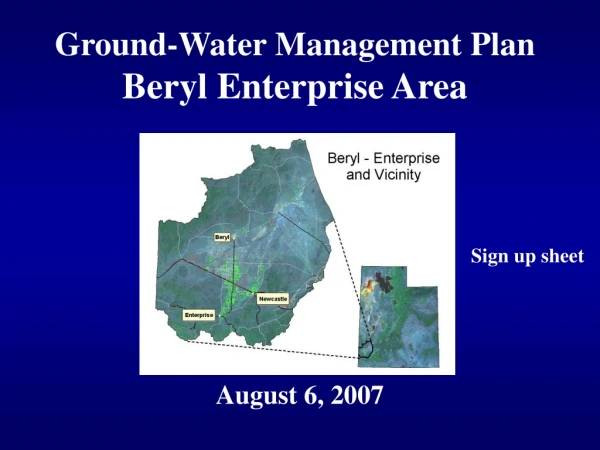
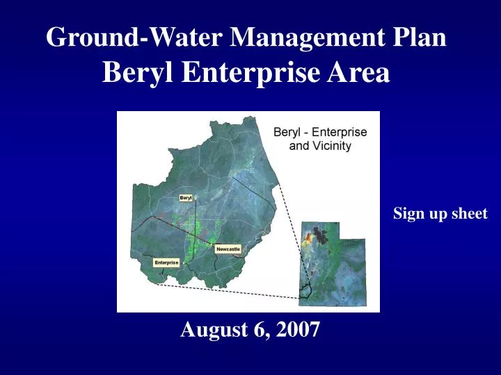
Ground-Water Management Plan Beryl Enterprise Area. August 6, 2007. Sign up sheet. Agenda. Water Management Issues Voluntary arrangements Management plan scenarios Water Rights Safe Yield Questions / Future directions Handout www.waterrights.utah.gov. Water Use Terms. Evaporation.

E N D
Ground-Water Management PlanBeryl Enterprise Area August 6, 2007 Sign up sheet
Agenda • Water Management Issues • Voluntary arrangements • Management plan scenarios • Water Rights • Safe Yield • Questions / Future directions • Handout • www.waterrights.utah.gov
Water Use Terms Evaporation ET = Evapotranspiration Transpiration Deep Percolation / Return Flow
Definitions • Consumptive Use (Irrigation) The quantity of water that is absorbed by the crop and transpired or used directly in the building of plant tissue, together with that evaporated from the cropped area. • Consumptive use – effective precip = Net irrigation requirement • Enterprise/Beryl Jct, Net irrigation requirement Alfalfa = 2.49 AF Grain = 1.66 AF Potatoes = 1.40 AF Corn = 1.38 AF
Definitions (cont’d) • Depletion - That part of the withdrawal that has been evaporated, transpired, incorporated into the crops or products, consumed by man or livestock, or otherwise removed. The wellhead diversion minus return flow to the groundwater aquifer. • CU + Incidental losses
Definitions (cont’d) • Irrigation Diversion Allowance - The quantity of water required to satisfy the irrigation water requirements and taking into account conveyance and application losses. Calculated using alfalfa and flood irrigation practices. In the 71 Area the irrigation diversion allowance is 4.0 acre-feet per acre per year. • Irrigation Duty (Duty)
Ground-Water Management Plan • Objectives of a plan Limit withdrawals to safe yield Protect the physical integrity Protect water quality • Principles of prior appropriation • Basin hydrology • Relationship surface & ground water • Well spacing • Well interference • Other relevant factors
Voluntary Arrangements • Subsection 4(c), 73-5-15, GW Mgt Plan • Water users may agree & participate Voluntary arrangements Consultation with state engineer Any time • Consistent with other law • If less than all water users Does not affect the rights of others
Possible Scenarios • Present 5 possible scenarios • Only for discussion purposes • Stimulate thought and debate • A target to consider
Scenario # 1 (stepped ) • Leave as is for a set period of time • End of initial period (# years) • Reduce diversions by set amount (%) • Monitor for set period (x yrs.) • Continue until safe yield reached Ac-Ft Time
Scenario #2 (new water) • Importation of water • Lake Powell Pipeline • Other options • Economics ?
Scenario #3 (steady & gradual) • Immediately begin reducing diversions • % reduction each year • Monitor water levels and diversions Ac-Ft Time
Scenario #4 (crop) • Reduce diversions by changing crops • Adjust cropping pattern alfalfa grain, potatoes & corn • Implement over time • Depletion target ( Safe yield )
Scenario #5 – Proposalset forth by Escalante Water Users • 1 year to develop resolution • Reduce the duty from 4.0 to 3.2 AF/A • 3.2 AF/A average over 5 years • Metering using power records • Cut water use 10%, 40-years (2,500 acs) • Compensation program ($10 million) 50% local & 50% state
Water Right Records • Review and update electronic records • Sole supply • Place of use groups • Certificate outstanding proofs
Safe Yield The perennial safe yield is equal to the amount of groundwater that can be withdrawn from the basin over a period of time without exceeding the long-term recharge of the basin or unreasonably affecting the basin’s physical and chemical integrity.
Hydrologic Studies • Hydrology Of The Beryl-Enterprise Area, Escalante Desert, … - Mower (1982) • Ground-water conditions in Utah - Burden (2005) • USGS National Information System Water Level Web Interface • Consumptive Use of Irrigated Crops in Utah – Hill (1994) • Acreage Surveys – Utah Division of Water Rights
Recharge Recharge Acre Feet Subsurface Inflow from Mountains/Streams 31,000 Precipitation on Valley Floor 500 320 Subsurface Inflow Return Flow from Surface Irrigation 1,400 34,000 Natural Recharge
Recharge Qrecharge + Δstorage = Qconsumptive Where: Qrecharge is the recharge to the aquifer Qconsumptive is the estimated crop depletions from well withdrawals. Δstorage is the calculated change in water stored in the aquifer 5 year period from 2001 to 2005
Recharge Qrecharge = Qconsumptive - Δstorage Where: Qrecharge is the recharge to the aquifer Qconsumptive is the estimated crop depletions from well withdrawals. Δstorage is the calculated change in water stored in the aquifer 5 year period from 2001 to 2005
Method 1 - Qconsumptive Well Withdrawal Estimates - USGS- 87,640 acft Consumptive Factor - HILL - 78 % Qconsumptive - 68,359 acft
Method 2 - Qconsumptive Underground Supplied Irrigation - 25,040 acres Consumptive Use - 2.49 acft/acre Qconsumptive - 62,348 acft
Δstorage USGS Observations 2001
Δstorage Water Level Surface 2001
Δstorage Water Level Surface 2006
Δstorage Water Level Surface 2006
Δstorage Drawdown From 2001 - 2006
Specific Yield - Porosity Specific yield is the ratio of the volume of water drained to the total rock volume Groundwater Model
Δstorage Specific Yield Δ Storage Δ Volume X Δ Storage = 31,425 acft
Recharge Qrecharge = Qconsumptive - Δstorage 33,575 = 65,000 - 31,425 Safe Yield = 34,000 acre feet / year
Safe Yield Best Estimate = 34,000 acre feet / year How will we know we have reached safe yield? Water Levels
Summary • Nothing is set in stone • Given you several proposals to consider • Allow you time to consider • Review the water right records • Comments – September 30 • Next meeting – late fall • Thank you