Download
1 / 38
1.04k likes | 5.34k Vues
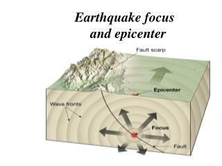
Earthquake focus and epicenter. What is an earthquake. Earthquakes and faults Movements that produce earthquakes are usually associated with large fractures in Earth’s crust called faults Most of the motion along faults can be explained by the plate tectonics theory.

E N D
What is an earthquake • Earthquakes and faults • Movements that produce earthquakes are usually associated with large fractures in Earth’s crust called faults • Most of the motion along faults can be explained by the plate tectonics theory
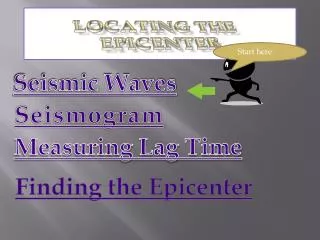
Seismology • The study of earthquake waves, seis-mology, dates back almost 2000 years to the Chinese • Seismographs, instruments that record seismic waves • Records the movement of Earth in relation to a stationary mass on a rotating drum or magnetic tape
Seismology • Seismographs • More than one type of seismograph is needed to record both vertical and horizontal ground motion • Records obtained are called seismograms • Types of seismic waves • Surface waves • Travel along outer part of Earth
Seismology • Types of seismic waves • Surface waves • Complex motion • Cause greatest destruction • Waves exhibit greatest amplitude and slowest velocity • Waves have the greatest periods (time in-terval between crests)
Seismology • Types of seismic waves • Body waves • Travel through Earth’s interior • Two types based on mode of travel • Primary (P) waves • Push-pull (compress and expand) motion, changing the volume of the intervening material • Travel through solids, liquids, and gases
Seismology • Types of seismic waves • Body waves • Primary (P) waves • Generally, in any solid material, P waves travel about 1.7 times faster than S waves • Secondary (S) waves • Shake" motion at right angles to their direction of travel • Travel only through solids
Seismology • Types of seismic waves • Body waves • Secondary (S) waves • Slower velocity than P waves • Slightly greater amplitude than P waves
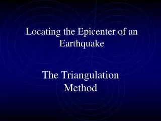
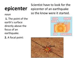
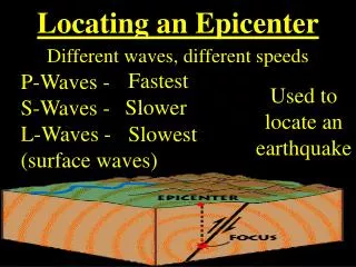
Locating the source of earthquakes • Terms • Focus - the place within Earth where earthquake waves originate • Epicenter – location on the surface directly above the focus • Epicenter is located using the difference in velocities of P and S waves
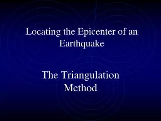
Locating the source of earthquakes • Locating the epicenter of an earthquake • Three station recordings are needed to locate an epicenter • Each station determines the time interval between the arrival of the first P wave and the first S wave at their location • A travel-time graph is used to determine each station’s distance to the epicenter
A time-travel graph is used to find the distance to the epicenter
Locating the source of earthquakes • Locating the epicenter of an earthquake • A circle with a radius equal to the distance to the epicenter is drawn around each station • The point where all three circles intersect is the earthquake epicenter
Locating the source of earthquakes • Earthquake belts • About 95 percent of the energy released by earthquakes originates in a few rela-tively narrow zones that wind around the globe • Major earthquake zones include the Circum-Pacific belt, Mediterranean Sea region to the Himalayan complex, and the oceanic ridge system
Distribution of magnitude 5 or greater earthquakes, 1980 - 1990
Locating the source of earthquakes • Earthquake depths • Earthquakes originate at depths ranging from 5 to nearly 700 kilometers • Earthquake foci arbitrarily classified asshallow (surface to 70 kilometers), intermediate (between 70 and 300 kilometers), and deep (over 300 kilometers)
Locating the source of earthquakes • Earthquake depths • Definite patterns exist • Shallow focus occur along the oceanic ridge system • Almost all deep-focus earthquakes occur in the circum-Pacific belt, particularly in regions situated landward of deep-ocean trenches
Measuring the size of earthquakes • Two measurements that describe the size of an earthquake are • Intensity – a measure of the degree of earthquake shaking at a given locale based on the amount of damage • Magnitude – estimates the amount of energy released at the source of the earthquake
Measuring the size of earthquakes • Intensity scales • Modified Mercalli Intensity Scale was developed using California buildings as its standard • The drawback of intensity scales is that destruction may not be a true measure of the earthquakes actual severity
Measuring the size of earthquakes • Magnitude scales • Richter magnitude - concept introduced by Charles Richter in 1935 • Richter scale • Based on the amplitude of the largest seismic wave recorded • Accounts for the decrease in wave amplitude with increased distance
Measuring the size of earthquakes • Magnitude scales • Richter scale • Largest magnitude recorded on a Wood-Anderson seismograph was 8.9 • Magnitudes less than 2.0 are not felt by humans • Each unit of Richter magnitude increase corresponds to a tenfold increase in wave amplitude and a 32-fold energy increase
Measuring the size of earthquakes • Magnitudes scales • Other magnitude scales • Several “Richter-like” magnitude scales have been developed • Moment magnitude was developed because none of the “Richter-like” magnitude scales adequately estimates the size of very large earthquakes • Derived from the amount of displacement that occurs along a fault
Earthquake destruction • Amount of structural damage attribu-table to earthquake vibrations depends on • Intensity and duration of the vibrations • Nature of the material upon which the structure rests • Design of the structure
Earthquake destruction • Destruction from seismic vibrations • Ground shaking • Regions within 20 to 50 kilometers of the epicenter will experience about the same intensity of ground shaking • However, destruction varies considerably mainly due to the nature of the ground on which the structures are built
Earthquake destruction • Destruction from seismic vibrations • Liquefactionof the ground • Unconsolidated materials saturated with water turn into a mobile fluid • Seiches • The rhythmic sloshing of water in lakes, reservoirs, and enclosed basins • Waves can weaken reservoir walls and cause destruction
Earthquake destruction • Tsunamis, or seismic sea waves • Destructive waves that are often inappropriately called “tidal waves” • Result from vertical displacement along a fault located on the ocean floor or a large undersea landslide triggered by an earth-quake
Earthquake destruction • Tsunamis, or seismic sea waves • In the open ocean height is usually less than 1 meter • In shallower coastal waters the water piles up to heights that occasionally exceed 30 meters • Can be very destructive • Landslides and ground subsidence