Download
1 / 6
60 likes | 102 Vues
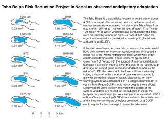
This project reduced the risk of a catastrophic glacial lake outburst flood in Nepal by lowering the level of the Tsho Rolpa lake through drainage and establishing an early warning system. The project cost $3.2 million and involved active participation of local villagers.

E N D
Tsho Rolpa Risk Reduction Project in Nepal as observedanticipatory adaptation The Tsho Rolpa is a glacial lake located at an altitude of about 4,580 m in Nepal. Glacier retreat and ice melt as a result of warmer temperature increased the size of the Tsho Rolpa from 0.23 km² in 1957/58 to 1.65 km² in 1997 (Figure 17.1). The 90- 100 million m³ of water, which the lake contained by this time, were only held by a moraine dam – a hazard that called for urgent action to reduce the risk of a catastrophic glacial lake outburst flood (GLOF). If the dam were breached, one third or more of the water could flood downstream. Among other considerations, this posed a major risk to the Khimti hydropower plant, which was under construction downstream. These concerns spurred the Government of Nepal, with the support of international donors, to initiate a project in 1998 to lower the level of the lake through drainage. An expert group recommended that, to reduce the risk of a GLOF, the lake should be lowered three metres by cutting a channel in the moraine. A gate was constructed to allow for controlled release of water. Meanwhile, an early warning system was established in 19 villages downstream in case a Tsho Rolpa GLOF should occur despite these efforts. Local villagers were actively involved in the design of the system, and drills are carried out periodically. In 2002, the fouryearconstruction project was completed at a cost of US$3.2 million. Clearly, reducing GLOF risks involves substantial costs and is time-consuming as complete prevention of a GLOF would require further drainage to lower the lake level.
Tsho Rolpa Risk Reduction Project in Nepal as observedanticipatory adaptation Channel 1 Channel 2 Tsho Rolpa hazard mitigation project site, October 2000 Engineers cut a notch in the moraine that holds back the lake; the notch was dammed and a sluice gate installed to allow controlled release of water. Sluice gate controlling flow notch cut in moraine bank of lake. Channel 3 http://rolwaling.tripod.com/2k/2k-tr-fix.html
Mapping vulnerability of theagricultural sector to both climate change and trade liberalizationat the district level in India The capacity to adapt to climate change is not evenly distributed within nations. O’Brien et al. (2004) consideredadaptive capacity as a key factor that influences outcomes. Districts in India that rank highest in terms of vulnerabilityto: (a) climate change and (b) import competition associated witheconomic globalization, are considered to be double exposed(depicted with hatching). Acombination of biophysical, socio-economic and technologicalconditions were considered to influence the capacity to adapt tochanging environmental and economic conditions. Thebiophysical factors included soil quality and depth, andgroundwater availability, whereas socio-economic factorsconsisted of measures of literacy, gender equity, and thepercentage of farmers and agricultural wage laborers in a district. Technological factors were captured by the availability ofirrigation and the quality of infrastructure. Together, these factorsprovide an indication of which districts are most and least able toadapt to drier conditions and variability in the Indian monsoons,as well as to respond to import competition resulting fromliberalised agricultural trade. The results of this vulnerabilitymapping show the districts that have ‘double exposure’ to bothprocesses. It is notable that districts located along the Indo-Gangetic Plains are less vulnerable to both processes, relative tothe interior parts of the country.
Geographical distribution of vulnerability in 2050 with and without mitigation along an SRES A2 emissions scenario with a climate sensitivity of 5.5°C.
Geographical distribution of vulnerability in 2100 with and without mitigation along an SRES A2 emissions scenario with a climate sensitivity of 5.5°C.