Download
1 / 5
50 likes | 66 Vues
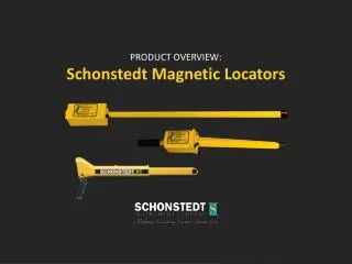
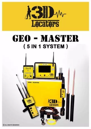
3D Locators is the first product to produce onsite<br>reporting which gives a fair idea about the geological terrain to fix a particular groundwater site, the Geo-master is equipped with multitasking<br>and multi reporting features which combines a set of data analysis and Geo-frequency reporting features and very low frequency<br>reporting features. <br>www.3dlocators.com<br>

E N D
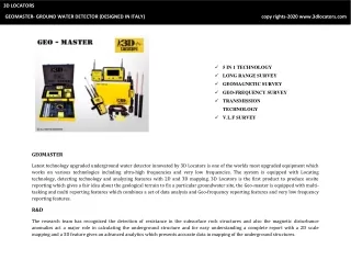
3D LOCATORS GEOMASTER- GROUND WATER DETECTOR (DESIGNED IN ITALY) copy rights-2020 www.3dlocators.com 5 IN 1 TECHNOLOGY LONG RANGE SURVEY GEOMAGNETIC SURVEY GEO-FREQUENCY SURVEY TRANSMISSION TECHNOLOGY V.L.F SURVEY GEOMASTER Latest technology upgraded underground water detector innovated by 3D Locators is one of the worlds most upgraded equipment which works on various technologies including ultra-high frequencies and very low frequencies. The system is equipped with Locating technology, detecting technology and analyzing features with 2D and 3D mapping. 3D Locators is the first product to produce onsite reporting which gives a fair idea about the geological terrain to fix a particular groundwater site, the Geo-master is equipped with multi- tasking and multi reporting features which combines a set of data analysis and Geo-frequency reporting features and very low frequency reporting features. R&D The research team has recognized the detection of resistance in the subsurface rock structures and also the magnetic disturbance anomalies act a major role in calculating the underground structure and for easy understanding a complete report with a 2D scale mapping and a 3D feature gives an advanced analytics which presents accurate data in mapping of the underground structures.
WHY GEOMASTER? GEOMASTER is designed on a platform with 5 different technologies to cross check a location where we have the Long range system to locate a fault zone, very low frequency system to analyze the strength of the rocks and geo- frequency system to explore the magnetic field difference in the hysteresis of a geological structure to finalize if the spot is permeable. Additionally we have the geomagnetic system and the transmission system for more accurate analysis of a particular area in targeting the exact fault zone. FAULT ZONE TARGETING Our professional long range locating system works with live transmission technology where in electrodes transmits the data’s from the ground and the long range system admits to prospect and locate the most precise fault zone by producing the live data on screen, Geo- master long range positioning system accepts the disturbance factors and displays the real time data to conform the target. The Geomagnetic locating system can be used in smaller areas where estimation is difficult by electrical surveys or frequency surveys, the geomagnetic survey can give a subsurface variation by measuring the surface magnetic field difference to present a precise data on fault zone detection. Geomagnetism is the study of the dynamics of the Earth's magnetic field, which is produced in the inner core. The Earth's magnetic field is predominantly a geo-axial dipole, with north and south magnetic poles located near the geographic poles that undergo periodic reversals and excursion.
VLF DETECTOR Very low frequency ground conductance measurement system calculates the data inbetween 0 mv to 3000 mv where electrodes are connected to the ground at a particular distance fixing the taget in the center and analizes the subsurface by frequency disturbance method to estimate a curve map followed by a 2D scale map to determine the strength of the rocks where in the color indications gives a fair idea and the contours play a major role in estimating the hard rock zones and weaker sections to determine if the fault zones can be further processed for water well drilling. Geo- Master VLF system also interprets 3D mapping post analysis where we can prospect each point in a row. SPRINCIPLE – in correlation of a frequency sent to the ground from one end and received at other end with multiple frequency modulation interpretation maps are generated per each point. VLF surveys can only estimate the resistance in frequency and can estimate the strength of the subsurface; Geo-master involves the next stage of survey represented as Geo-frequency analysis to estimate the permeable factor and quantum analysis. www.3dlocators.com/geomaster
GEO-FREQUENCY SURVEY Geo- Frequency survey works on the field magnetic anomalies by conducting the variation in field difference at equal distance measuring the subsurface lithology to estimate the permeable factor and generate a complete report. The intensity of the field is often measured in gauss (G), but is generally reported in nano teslas (nT), with 1 G = 100,000 nT. A nano tesla is also referred to as a gamma (γ).[13] The tesla is the SI unit of the magnetic field, The Earth's field ranges between approximately 25,000 and 65,000 nT (0.25–0.65 G). By comparison, a strong refrigerator magnet has a field of about 10,000,000 nano teslas (100 G). For estimating, calculation and easy understanding Geo-master has routed the values in between 0-100. The Estimation of Permeable zone gives the indication of porous medium to confirm an aquifer and its features by reporting the rock strength, quality, salinity depth and permeable factor. www.3dlocators.it/geofrequency www.3dlocators.com/geofrequency
GEOMASTER has completed its case studies on various geological structures I Sedimentary, metemorphic and ignesious terrain, the equipment was designed in a aim to provide solution to varied geological conditions the 5 inbuilt technologies, gives a user friemndly equipment handeling experience and the user has a flexibility in selecting a required technology as per the influence of the geological structure. Groundwater exploration is not only scientific but it requires higher concentration and passion to study each different area adheiring with the surface water presence, geomorphology, hydro-geology and altitude of the site location, although preb ore hole records gives a fair idea in estimating a location, Geo-Master is one of the most equiped tool to scientifically test the particular site for its yielding channels. We have a 2 Mode detection in Geo-frequency survey where we use the VLF technology to estimate the right zone where the rock strenth is not high so that it gives a fair idea of a weaker zone selection, and thew Geo frequency survey conducts a analysis on the variation in magnetic field to determine the evidence of permeability and determines the frequency disturbance to present the complete report of the subsurface lithology. For more information on GEO-MASTER we request our customers to visit our website www.3dlocators.com or www.3dlocators.it We have a support team for eqeuipment assistance and coordination We have a warranty support through our distributors channel globally Our products are flexible with 2 years warranty coverage. www.3dlocators.com 3D LOCATORS GEOMASTER INFORMATION BOOKLET Copyrights 2020