Download
1 / 4
40 likes | 133 Vues
Explore the INGV National Seismic Network's comprehensive setup in 2013, featuring integrated stations with advanced technology for precise earthquake detection and analysis in the Mediterranean basin. Benefit from high-quality data acquisition, management, and analysis to improve early warning systems and seismic research. Discover the Emilia 2012 and Pollino 2011-2013 seismic networks, enhancing detection capabilities during emergencies and providing valuable research data on fault structures and seismic activity. Learn about the ITalianACcelerometric Archive (ITACA) and the Rete Integrata Nazionale GPS for in-depth geodetic measurements.

E N D
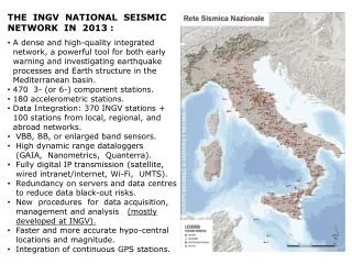
THE INGV NATIONAL SEISMIC NETWORK IN 2013 : • A dense and high-qualityintegrated • network, a powerfultoolforbothearly • warning and investigatingearthquake • processes and Earthstructure in the • Mediterraneanbasin. • 470 3- (or 6-) componentstations. • 180 accelerometricstations. • Data Integration: 370 INGV stations + • 100 stationsfromlocal, regional, and • abroadnetworks. • VBB, BB, or enlarged band sensors. • High dynamicrangedataloggers • (GAIA, Nanometrics, Quanterra). • Fullydigital IP transmission (satellite, • wired intranet/internet, Wi-Fi, UMTS). • Redundancy on servers and data centres • to reduce data black-out risks. • New proceduresfor data acquisition, • management and analysis(mostly • developed at INGV). • Faster and more accurate hypo-central • locations and magnitude. • Integrationofcontinuous GPS stations.
INGV portableSeismicNetwork Emilia 2012 Is composed by more than 100 seismic stations equipped with both accelometers and velocimiters.Stations can be easily and quickly deployed Data can be transmitted in real time at INGV (UMTS. WiFi or satellite)Data are stored in EIDA archive Montello 2011 • Portable seismic networks are deployed to improve the detection performance of permanent monitoring systems during seismic emergency or experiments • The improvement in earthquake detection and location provide invaluable data for scientific studies related to hazard, tectonics and earthquake physics. • Aftershocks or clusters of seismic events help in characterizing the geometry and dimensions of the causative faults. • Knowing the number, size, and timing of aftershocks can help in foreseeing the characteristics of future seismic sequences in the same tectonic environment. Emilia 2012 Seismic EmergenciesandExperiments Pollino 2011-2013
ITalianACcelerometic Archive (ITACA) ITACA 1.1 (1972-2011): 4800 three-component waveformsfrom ≈1000 earthquakes with M > 3 and ≈900 stations (almostentirely from the nationalaccelerometric network RAN) Soonversion 2.0 will be releasedincluding data from 1972 to 2013 from allseismic networks operating in Italy
RINGRete Integrata Nazionale Gps • Geodetic GPS/GNSS Data (Global Positioning System/Global Navigation Satellite System), enable millimeter-scale surface motion measurements at discrete points • Permanent GPS/GNSS stations track both the slow interseismic deformation and the sudden elastic release by earthquakes • INGV promotes the development of new, high-quality GPS stations and the integration of existing GPS/GNSS networks (government and commercial) • ~500 permanent GPS stations now provide an accurate image of the tectonic deformation in Italy • RING scientific goals are to understand: • The forces that drive plate-boundary deformation • The spatial distribution of tectonic deformation and earthquake occurrence in Italy • How to reduce the hazards related to earthquakes