28 Jan
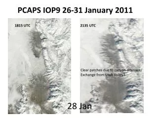
PCAPS IOP9 26-31 January 2011. 28 Jan. 1815 UTC. 2135 UTC. Clear patches due to canyon drainage/ Exchange from Utah Valley?. Interesting Science Questions in IOP9. Cadillac PCAPS observations (everything working!! Lots of sondes !!) Synoptic flow relatively weak 27-28 Jan.

28 Jan
E N D
Presentation Transcript
PCAPS IOP9 26-31 January 2011 28 Jan 1815 UTC 2135 UTC Clear patches due to canyon drainage/ Exchange from Utah Valley?
Interesting Science Questions in IOP9 • Cadillac PCAPS observations (everything working!! Lots of sondes!!) • Synoptic flow relatively weak 27-28 Jan. • Role of lake/ lake breezes • Role of clouds (large differences N to S) • Role of ‘clear’ Utah Valley • Role of increasing channeled southerly flow • Role of canyon slope flows (number of sondes on slopes/canyons) • Role of surface variations (variable snow cover)
WRF Model Initial Set-up • Test ‘standard’ NWP setup • Following Alcott and Steenburgh (2012) and Lu and Zhong (2012) • Computationally inexpensive—entire IOP9 period (~120 hrs) runs on 100 parallel computers in ~20 hours • 3 nested grids (12 km, 4 km, 1.33 km), 72 vertical levels • Currently testing various combinations of microphysics, PBL, radiation, etc… (including NEW Jimenez surface layer for stable conditions in WRF V3.4.1 release) • This is what we will be showing output from today (LES pending)
WRF Model Real-Case LES Set-up • Following general approach of Talbot et al. 2012: Nested mesoscale-large eddy simulations with WRF: performance in real test cases J Hydrometeorology early online release Computationally expensitve-- on 100 parallel computers 1 hour of simulation time takes 24 hours!! • 3 nested grids (5 km, 1 km, 200 m), 72 vertical levels • No output to show yet—still testing--will be forthcoming in next few weeks
WRF LES Domain 5 km/ 1 km/ 200 m domains 200m 1000m 5000m
PLOTS IN THIS PRESENTATION OF COARSE DOMAIN MODEL FIELDS (LES to FOLLOW) • LES has been ‘blowing up’, need to make smaller time step which further increases computation time
IOP9: Development of surface inversion (lowest model level temp and winds plotted) 6 hr 0600 UTC 26 Jan 30 hr 1200 UTC 27 Jan—cooler air Forming around lake basin
54 hr 0600 UTC 28 Jan—cooler air Forming around lake basin 78 hr 0600 UTC 28 Jan—warming aloft increases temp difference. Utah valley too warm
Vertical Cross-Sections North Center_NS East Center_EW Will show South
Vertical Cross-Sections Center_NS Will show
48 hr 0000 UTC 28 Jan Large horizontal temp differences and ‘lake surge’ relatively well-captured 3 hr later 0300 UTC 28 Jan cool lake surge has now filled valley as shown in observations… Traverse ridge
63 hr 1500 UTC 28 Jan Southerly channeled/drainage flow is bit too strong in model. Hr 69 2100 UTC 28 Jan lake breeze with onshore low-level flow and channeled southerly/elevated drainage jet ~800 mb
Vertical Cross-Sections Center_EW
21 UTC Lake breeze penetration on west side starts easterly cross-valley flow 18 UTC 28 Jan Weak slope flows
00 UTC Interesting how lake breeze is on ‘west slope!’ 06 UTC light cross-valley winds and homogeneous T
East Outflow from parley’s and mill Creek 1-2 m/s night til noon day… no Other canyon flow resolved at 1.33 km Black = westerly wind White = easterly
Modulating Cloud Cover High RH Salt Lake Valley Low RH Utah Valley
WRF MODEL vs OBS (Temperature 27 Jan) at ISFS 1, 4, and 7 (wrf under-predicts surface temp swings ISFS7 and over-predicts near lake
WRF MODEL vs OBS (Wind Speed 27 Jan) at ISFS 1, 4, and 7. For this period model underestimates wind speeds both from Utah Valley and lake breeze on late 27th