
Driving Instructions to Lew’s Place for BSA Troop 1548: Complete Route Guide
Follow these detailed driving instructions to reach Lew's Place for BSA Troop 1548's activities. Start by leaving Rocky Run and head south on Stringfellow Road, then turn left onto Fair Lakes Parkway. Continue south on VA State Hwy 7100 and I-95. Make necessary turns onto US Route 17 and VA State Hwy 360 before navigating through towns and intersections. Finally, follow the dirt road past a small white house with a tin roof to find the camp location. Detailed maps and final approach instructions included for ease of navigation.

Driving Instructions to Lew’s Place for BSA Troop 1548: Complete Route Guide
E N D
Presentation Transcript
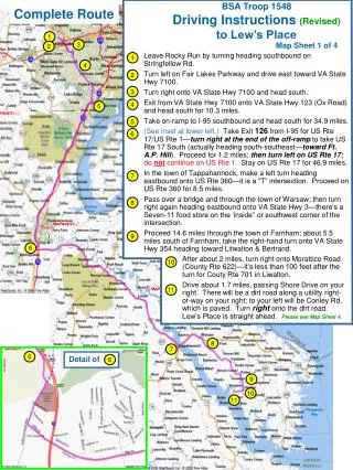
BSA Troop 1548 Driving Instructions (Revised) to Lew’s Place Complete Route 1 3 2 4 5 6 8 7 6 Detail of 6 9 10 11 Map Sheet 1 of 4 Leave Rocky Run by turning heading southbound on Stringfellow Rd. Turn left on Fair Lakes Parkway and drive east toward VA State Hwy 7100. Turn right onto VA State Hwy 7100 and head south. Exit from VA State Hwy 7100 onto VA State Hwy 123 (Ox Road) and head south for 10.3 miles. Take on-ramp to I-95 southbound and head south for 34.9 miles. (See inset at lower left.) Take Exit 126 from I-95 for US Rte 17/US Rte 1—turn right at the end of the off-ramp to take US Rte 17 South (actually heading south-southeast—toward Ft. A.P. Hill). Proceed for 1.2 miles; then turn left on US Rte 17; donotcontinue on US Rte 1. Stay on US Rte 17 for 46.9 miles. In the town of Tappahannock, make a left turn heading eastbound onto US Rte 360—it is a “T” intersection. Proceed on US Rte 360 for 8.5 miles. Pass over a bridge and through the town of Warsaw; then turn right again heading eastbound onto VA State Hwy 3—there’s a Seven-11 food store on the ‘inside” or southwest corner of the intersection. Proceed 14.6 miles through the town of Farnham; about 5.5 miles south of Farnham, take the right-hand turn onto VA State Hwy 354 heading toward Litwalton & Bertrand. 1 2 3 4 5 6 7 8 9 After about 2 miles, turn right onto Morattico Road (County Rte 622)—it’s less than 100 feet after the turn for Couty Rte 701 in Liwalton. Drive about 1.7 miles, passing Shore Drive on your right. There will be a dirt road along a uitility right-of-way on your right; to your left will be Conley Rd, which is paved. Turn right onto the dirt road. Lew’s Place is straight ahead. Please see Map Sheet 4. 10 11
1 3 2 4 5 BSA Troop 1548 Driving Instructions to Lew’s Place Expanded View—Getting to Interstate 95 Map Sheet 2 of 4
9 10 11 Detail—Final Approach Lew’s Place 11 Conley Rd Expanded View—Last Leg BSA Troop 1548 Driving Instructions to Lew’s Place Map Sheet 3 of 4 Instructions—Final Approach Drive about 1.7 miles, passing Shore Drive on your right. There will be a dirt road along a uitility right-of-way on your right; to your left will be Conley Rd, which is paved. Turn right onto the dirt road. Lew’s Place is straight ahead.. Once on the dirt road leading to Lew’s Place, follow it to the first bend in the road: do NOT follow the bend; instead proceed essentially straight ahead across a very small bridge and through a field. Follow the gravel road to the first parking area. You will see a small white house with a tin roof. This is Lew’s Place. Troop 1548 generally camps past Lew’s House so continue down the gravel road until you find the rest of us. 11
BSA Troop 1548 Driving Instructions to Lew’s Place Instructions—Final Approach [After turning off of VA St Hwy 354,] drive about 1.7 miles, passing Shore Drive on your right. There will be a dirt road along a uitility right-of-way on your right (in a narrow gap in the trees to your right); to your left will be Conley Rd, which is paved. Turn right onto the dirt road. Lew’s Place is straight ahead. Once on the dirt road leading to Lew’s Place, follow it to the first bend in the road: do NOT follow the bend; instead proceed essentially straight ahead across a very small bridge and through a field. Follow the gravel road to the first parking area. You will see a small white house with a tin roof. This is Lew’s Place. Troop 1548 generally camps past Lew’s House so continue down the gravel road until you find the rest of us. 11 Turn right at dirt road opposite Conley Road Map Sheet 4 of 4 Shore Drive dirt road 11 Conley Rd