Mapping Alaska Initiative Status January 2012
120 likes | 335 Vues
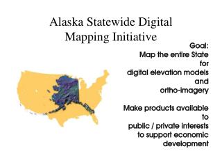
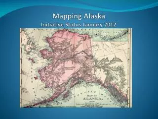
Mapping Alaska Initiative Status January 2012. Size and Distance Comparison. Barrow. New York. Juneau. Orlando. At 586,400 square miles, Alaska is as wide as the lower 48 states and larger than Texas, California and Montana combined. 1,100 miles. 1,100 miles.

Mapping Alaska Initiative Status January 2012
E N D
Presentation Transcript
Size and Distance Comparison Barrow New York Juneau Orlando At 586,400 square miles, Alaska is as wide as the lower 48 states and larger than Texas, California and Montana combined 1,100 miles 1,100 miles
Some Guiding Principles • Establish a mapping program within AK that is commensurate with the mapping program for the lower 48 to meet high priority needs for safety, planning, research and resources management applications across multiple communities of use • Seek partnerships with the AK stakeholders for leadership in defining, communicating and funding mapping activities with emphasis on elevation and imagery under the SDMI. Coordinate efforts with recently completed business plan (CAP grant). • There is a scarcity of suitable data. This will require even greater emphasis and creativity working with Alaska state agencies and other stakeholders for acquisition. • Alaska maps will be mass-produced products. Upgrading source databases, via bulk data collections and partnerships, and remaking US Topos on a cycle (as opposed to extensive research and attention to each individual map) are the primary mechanisms for improving the overall accuracy and completeness of the series.
Proposed Characteristics for Statewide US Topo Products in AK Use scale of either 1:25K or 1:50K (to achieve statewide coverage this cycle) Use AK DNR SPOT orthoimagery (2.5m resolution) --currently underway with 3+ year production remaining Use IFSAR (or LIDAR where available) for contours -- currently ~20% of AK in work or complete; 7+ years @ current rate Use TomTom for trans & structures (seek alternatives or augment) Use NHD & GNIS: assess likely level of effort to align w/ new image & contours. Use State Department International Boundaries Use BLM for Federal and Borough Boundaries Evaluate statewide options for other feature layers, most notably boundaries and PLSS
SDMI Elevation Project Deliverables DTM DSM • Three normal airborne IFSAR products • Could register satellite imagery to ORI to improve positional accuracy with minimal GCPs ORI Credit: Dave Maune, Dewbery
ADNR Ortho Project Data:Pseudo Natural Color – 2.5 meter Pan-Sharpened Deliverables include: pseudo natural-color, CIR, and panchromatic
Key Technical and Programmatic concerns General lack of suitable statewide data & difficulty of collection Risks inherent in dependency on external data programs (e.g. delays, accuracy, pace, and the difference between the ortho and IFSAR efforts) Challenge of schedule, objectives, and source staging for pilots Challenge of placing and training new hires Data integration efforts are unknown Need for development for irregular map extents
Status of ADNR Ortho Project and SDMI Elevation Project
Standard CellsCovered completely with both IFSAR and SPOT in 2012 Cells are those used for the 1:63,360 legacy series. 15’ in latitude, vary in longitude. 18 cells (IFSAR license “uplift” area) (Green = National Parks) 19 cells. Neither the city of Fairbanks nor any part of Denali National Park have coverage. NGP Quarterly November 3, 2011
Coordination Efforts • Coordination with USGS Alaska Science Center • Coordinate with AK DNR for SPOT Imagery and Ortho Production • Contribute to SDMI IFSAR program. • Coordinate efforts with recently completed a business plan (CAP grant). • Local contact with other federal agencies through Alaska Science Center and Liaison network and the Alaska Geographic Data Committee • Participating in Upcoming Alaska Surveying and Mapping Conference • Preparation of draft sample products and developing feedback mechanisms, • Meet with partners and Communities of Use • Increase staffing – • Assign Project Coordinator; Refocus Idaho Liaison to Alaska; Hiring AK Liaison • Hiring Technical Operations Center personnel • FGDC Coordination Group