
Radon Levels and Geology of West Virginia: A Comprehensive Study (1998-2003)
This study analyzes radon measurements across 764 zip codes in West Virginia from 1998 to 2003. Out of the 764 zip codes evaluated, 540 had at least one radon measurement, and 361 had five or more measurements. It was found that 11% of these zip codes exceeded the US EPA's action level of 4 pCi/L for radon levels. Additionally, 19% showed elevated radon measurements based on dominant bedrock type. This research contributes essential insights into the geological factors influencing radon exposure in West Virginia.

Radon Levels and Geology of West Virginia: A Comprehensive Study (1998-2003)
E N D
Presentation Transcript
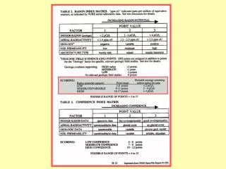
(1988, 1990) (>4) (2-4) (<2)
Geology of West Virginia
764 West Virginia Zip Codes
19,914 measurements • 1998-2003 • 540 of 764 zip codes (71%) • Estimated 4.4% of residences
Zip Codes with 5 or more Measurements: 361 of 764 (47%)
Zip codes with Median Radon Exceeding US EPA Action level (4 pCi/L): 41 of 361 (11%)
Zip codes with > 40% of Measurements Exceeding US EPA Action level (4 pCi/L): 100 of 540 (19%)
Percent Elevated Radon Measurements as a Function of Dominant Bedrock Type In WV Zip Codes 75th percentile 50th percentile n = 16 n = 1 25th percentile n = 340 n = 16 n =165