“Gustav” 2002
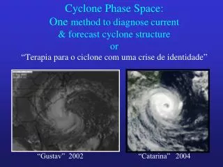
Cyclone Phase Space: One method to diagnose current & forecast cyclone structure or “ Terapia para o ciclone com uma crise de identidade ”. “Gustav” 2002. “Catarina” 2004. Motivation. Cyclones are not simply “tropical” or “extratropical” There is a great range of hybrid-type cyclones

“Gustav” 2002
E N D
Presentation Transcript
Cyclone Phase Space: One method to diagnose current & forecast cyclone structureor“Terapia para o ciclone com uma crise de identidade” “Gustav” 2002 “Catarina” 2004
Motivation • Cyclones are not simply “tropical” or “extratropical” • There is a great range of hybrid-type cyclones • These are often the most challenging since we do not have conceptual models for them • Do these cyclones exist because of competing energy sources? • We will take a fresh look at the range of cyclone structure and propose a method to classify them all
Images courtesy NCDC Test: Separate the 5 tropical cyclones from the 5 non-tropical.
Some relevant questions… • What makes a cyclone warm or cold-core? • If all low pressure areas result from a column of air that is on average warmer than its environment, how can there be cold-core cyclones? • What are the hydrostatic consequences of this thermodynamic structure & the resulting profile of cyclone “strength”? • What about existence of mixed phase cyclones? • Why do we care? 60 knots is 60 knots!
Model interpretation: What type of development? PMIN=1009hPa PMIN=1001hPa PMIN=1005hPa PMIN=1003hPa
Why is the phase of a cyclone important? • Predictability is a function of cyclone phase • Model interpretation/trust is a function of phase • It is often not at first apparent what the model is forecasting, or the nature of cyclone development • Peak intensity is a function of cyclone phase
? 940hPa Non-conventional cyclones: Examples 1938 New England Hurricane • Began as intense tropical cyclone • Rapid transformation into an intense hybrid cyclone over New England (left) • Enormous damage ($5-10 billion adjusted to 2008). 10% of trees downed in New England. 600+ lives lost. • Basic theories do not explain a frontal hurricane Pierce 1939
Example of nonclassic structure 21 December 1994 22 December 1994 23 December 1994 24 December 1994
Non-conventional cyclones: Examples Christmas 1994 Hybrid New England Storm • Gulf of Mexico extratropical cyclone that acquired partial tropical characteristics • A partial eye was observed when the cyclone was just east of Long Island • Wind gusts of 50-100mph observed across southern New England • Largest U.S. power outage (350,000) since Andrew in 1992 • Forecast 6hr earlier: chance of light rain, winds of 5-15mph. NCDC
Non-conventional cyclones: Examples Catarina (2004) • Demonstrates that we cannot rely purely on the historical record to diagnose and forecast structure • What was Catarina? • We can say it “looks” more like a hurricane than a significant number of north Atlantic hurricanes! NCDC
Summary of relevance: • Classification • Better understanding of the current state • Applying conceptual models • The type/extent of expected impact/damage • Quantifying potential for intensity change and uncertainty • How can intensity change be forecast if there is great structural uncertainty? • Amount of intrinsic (mis)trust of numerical model forecasts
The end result:We need a diagnosis of basic cyclone structure that is more flexible than only tropical or extratropical
Goal:A more flexible approach to cyclone characterization • To describe the basic structure of tropical, extratropical, and hybrid cyclones simultaneously using a cyclone phase space. Parameter B Phase Space Parameter C Parameter A
What parameters to use? • Maximum wind? Minimum pressure? • Too simple & does not discriminate • Vorticity? • What level? • Potential vorticity? • Separating vorticity and stability is important • Q-vectors? • Does not simplify the continuum • Energetics? • Ideal, but not practical in real-time • Something more basic: thermal wind & asymmetry
Let us begin with a review the structure of the text-book cyclone types
Hurricane Bonnie (1998) Temperature Anomaly Classic warm-core cyclone: TC 12km 6km 1km - Low pressure results from column of air on average warmer than environment, with the anomalous warmth in the troposphere Source: Advanced Microwave Sounder (AMSU) Temperature Anomaly + Image courtesy Mark DeMaria, CIRA/CSU www.cira.colostate.edu/ramm/tropic/amsustrm.asp
Classic warm-core cyclone: TC TC Height Field (m) from hydrostatic balance Warm: expansion of surfaces Cold: contraction of height surface
Classic warm-core cyclone: TC Height anomaly from zonal mean shaded Height anomaly increases with altitude in troposphere
- + Cold Stratosphere Z Troposphere Wa rm L Height anomaly Classic warm-core cyclone: TC • Intensifies through: sustained convection, surface fluxes. • Cyclone strength greatest near the top of the PBL Gradient wind balance in a convective environ.
Classic cold-core cyclone: Extratropical Cleveland Superbomb Temperature Anomaly Low pressure results from column of air on average warmer than environment, with the anomalous warmth in the stratosphere L 2.5 NCAR/NCEP reanalysis
Classic cold-core cyclone: Extratropical Height anomaly from zonal mean shaded Height anomaly decreases with altitude in troposphere
- + Height anomaly over sfc center Classic cold-core cyclone: Extratropical • Intensifies through: baroclinic development, tropopause lowering. • Cyclone strength greatest near tropopause QG balance in a minimally convective environ Cold Warm Stratosphere Z Troposphere Cold Warm L
- + Warmer Stratosphere Z Troposphere Colder Warmer L Height anomaly over sfc center Hybrid (non-conventional) cyclone What if an occluded extratropical cyclone moves over warm water? Characteristics of tropical and extratropical cyclones.
- - - + + + Height anomaly Height anomaly Height anomaly Cyclone Parameters 1 and 2: Vertical structure -VT: Thermal Wind [Warm vs. Cold Core] Warm core Hybrid Cold Core 300mb 600mb 900mb
Two layers of interest Cyclone Parameter -VT: Thermal Wind Warm-core example: Hurricane Floyd 14 Sep 1999 Vertical profile of ZMAX-ZMIN is proportional to thermal wind (VT). Z Z Z Z Z Z Z Z Z
Cyclone Parameter -VT: Thermal Wind Cold-core example: Cleveland Superbomb 26 Jan 1978
Third dimension? • We now have two parameters of the CPS that discriminate the vertical structure of a cyclone: warm vs. cold vs. hybrid core • What about the horizontal structure? • How do we separate the horizontal structure of the various types of cyclones? • Ultimately, a good measure is frontal nature (baroclinic vs. barotropic structure)
Cyclone Parameter 3: Horizontal structureB: Thermal Asymmetry Symmetric Hybrid Asymmetric
Cyclone Parameter B: Thermal Asymmetry • Defined using storm-relative 900-600hPa mean thickness field (shaded) asymmetry within 500km radius: B >> 0: Frontal B0: Nonfrontal 3160m 3260m L Cold Warm
Conventional Tropical cyclone: B 0 Forming Mature Decay L L L • Conventional Extratropical cyclone: B varies Developing Mature Occlusion L L L B >> 0 B > 0 B 0 Cyclone Parameter B: Thermal Asymmetry
Constructing 3-D phase space from cyclone parameters: B, -VTL, -VTU A trajectory within 3-D generally too complex to visualize in an operational setting Take two cross sections (slices) : B -VTU -VTL -VTL
Hurricane Mitch (1998)Case of symmetric, warm-core development and decay Classic tropical cyclone
Symmetric warm-core evolution: Hurricane Mitch (1998)Slice 1: B Vs. -VTL
Symmetric warm-core evolution: Hurricane Mitch (1998)Slice 1: B Vs. -VTL
Symmetric warm-core evolution: Hurricane Mitch (1998)Slice 2: -VTL Vs. -VTU Upward warm core development maturity, and decay. With landfall, warm-core weakens more rapidly in lower troposphere than upper.
Symmetric warm-core evolution: Hurricane Mitch (1998)Slice 2: -VTL Vs. -VTU Upward warm core development maturity, and decay. With landfall, warm-core weakens more rapidly in lower troposphere than upper.
December 1987 Extratropical CycloneCase of asymmetric, cold-core development and decayClassic occlusion of an extratropical cyclone
Asymmetric cold-core evolution: Extratropical CycloneSlice 1: B Vs. -VTL
Asymmetric cold-core evolution: Extratropical Cyclone Slice 2: -VTL Vs. –VTU
Hurricane Floyd (1999)Multiple phase evolution:Case of extratropical transition of a tropical cyclone
5 4 Warm-to-cold core transition: Extratropical Transition of Hurricane Floyd (1999): B Vs. -VTL 3 5 B 2 4 3 1 1 2 -VTL
Extratropical transition ends when –VTL < 0 B Extratropical transition begins when B=10m -VTL Warm-to-cold core transition: Extratropical Transition of Hurricane Floyd (1999) B Vs. -VTL Provides for objective indicators of extratropical transition lifecycle.
Spaghetti Plot of 34 Cyclone Phase Trajectories based upon Navy NOGAPS operational analyses 960hPa 970hPa 980hPa 990hPa 1000hPa 1010hPa Asymmetric Cold-Core Asymmetric Warm-core B Symmetric Cold-core Symmetric Warm Core -VTL
Composite Mean ET Structural Evolution Summary 34-Cyclone Composite Mean Phase NOGAPS-analysis based Trajectory with key milestones labeled TE+24h TE TE+48h TMID TB TE+72h TB-24h TB-72h TB-48h
Variability About the Composite Mean Boxes represent the calculated one standard deviation spread about the 34-cyclone consensus mean trajectory for each time Considerable variability about mean once transition completed=> posttropical phase can take many forms….